Property Record
20 Wilson Rd, Stockbridge, GA 30281
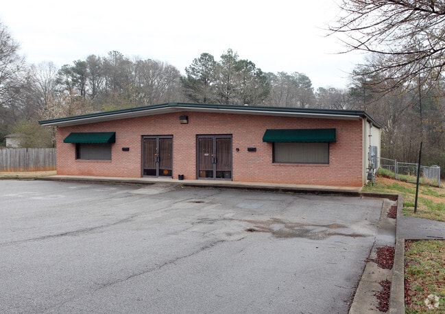

Property Detail
20 Wilson Rd
069B-02-013-000
LD: 11LL: 32
Officebuilding
Henry
C1
Georgia
B and X Area of moderate flood hazard, usually the area between the limits of the 100-year and 500-year floods.
13
2025
0.66 AC
2025
South Clayton/Henry Cnty
070212
Atlanta
2,430 SF
Atlanta-Sandy Springs-Roswell, GA
NEARBY LISTINGS FOR SALE OR LEASE
DEMOGRAPHICS near 20 Wilson Rd
1 mile
3 mile
5 mile
2025 Total Population
4,267
36,106
92,679
2030 Population
4,510
38,385
98,198
Pop Growth 2025-2030
+ 5.69%
+ 6.31%
+ 5.95%
Average Age
37
39
39
2025 Total Households
1,617
13,092
33,010
HH Growth 2025-2030
+ 5.81%
+ 6.40%
+ 6.01%
Median Household Inc
$79,570
$76,745
$77,520
Avg Household Size
2.60
2.70
2.80
2025 Avg HH Vehicles
2.00
2.00
2.00
Median Home Value
$198,935
$333,281
$326,423
Median Year Built
1992
1995
1996
Nearby Places
Map Layers
Map Styles
 Street
 Aerial
Layers
 Traffic
 Biking
Places
Listings with unknown addresses are not visible on the map
- Restaurants
- Banks
- Shops
- Fitness
- Groceries
PUBLIC TRANSPORTATION
AIRPORT
Hartsfield - Jackson Atlanta International
Drive
Walk
Distance
Hartsfield - Jackson Atlanta International
28 min
18.5 mi
SALE & LEASE HISTORY
LISTING DATE
SALE/LEASE

Nov 11, 2024
For Lease
Jul 16, 2024
For Sale
Nearby Properties
Address
Land Use
TOTAL SIZE
Lot Size
Zoning
Address
Land Use
TOTAL SIZE
Lot Size
Zoning
22,400 SF
45.37 AC
RM
Address
Land Use
TOTAL SIZE
Lot Size
Zoning
476,716 SF
28.93 AC
C2
Address
Land Use
TOTAL SIZE
Lot Size
Zoning
4,010 SF
37.60 AC
C2
Address
Land Use
TOTAL SIZE
Lot Size
Zoning
19,140 SF
40.11 AC
RM
Address
Land Use
TOTAL SIZE
Lot Size
Zoning
21,678 SF
26.44 AC
RM
Address
Land Use
TOTAL SIZE
Lot Size
Zoning
13,072 SF
32.50 AC
RM
Address
Land Use
TOTAL SIZE
Lot Size
Zoning
707,800 SF
27.81 AC
M1
Address
Land Use
TOTAL SIZE
Lot Size
Zoning
25,952 SF
28.88 AC
RM
Address
Land Use
TOTAL SIZE
Lot Size
Zoning
9,264 SF
26.63 AC
RM
Address
Land Use
TOTAL SIZE
Lot Size
Zoning
510,053 SF
39.93 AC
M1
Address
Land Use
TOTAL SIZE
Lot Size
Zoning
25,508 SF
26.03 AC
RM
Address
Land Use
TOTAL SIZE
Lot Size
Zoning
439,225 SF
19.81 AC
M1
Address
Land Use
TOTAL SIZE
Lot Size
Zoning
399,189 SF
29.60 AC
M1
Address
Land Use
TOTAL SIZE
Lot Size
Zoning
269,100 SF
30.64 AC
Address
Land Use
TOTAL SIZE
Lot Size
Zoning
425,476 SF
58.85 AC
PD
Address
Land Use
TOTAL SIZE
Lot Size
Zoning
74,395 SF
49.35 AC
PD
Address
Land Use
TOTAL SIZE
Lot Size
Zoning
111,398 SF
15.54 AC
C2
Address
Land Use
TOTAL SIZE
Lot Size
Zoning
68,500 SF
140.42 AC
R2
Address
Land Use
TOTAL SIZE
Lot Size
Zoning
216,361 SF
27.44 AC
C3
Address
Land Use
TOTAL SIZE
Lot Size
Zoning
62,142 SF
4.36 AC
C1
Address
Land Use
TOTAL SIZE
Lot Size
Zoning
8,590 SF
11.09 AC
R3
Address
Land Use
TOTAL SIZE
Lot Size
Zoning
466,048 SF
6.51 AC
RA
Address
Land Use
TOTAL SIZE
Lot Size
Zoning
66,194 SF
9.67 AC
C3
Address
Land Use
TOTAL SIZE
Lot Size
Zoning
46,186 SF
9.99 AC
C2
Address
Land Use
TOTAL SIZE
Lot Size
Zoning
46,964 SF
2.72 AC
Address
Land Use
TOTAL SIZE
Lot Size
Zoning
30,888 SF
5.10 AC
Address
Land Use
TOTAL SIZE
Lot Size
Zoning
196,437 SF
7.98 AC
C2
Address
Land Use
TOTAL SIZE
Lot Size
Zoning
25,020 SF
169.25 AC
RA
Address
Land Use
TOTAL SIZE
Lot Size
Zoning
33,993 SF
4.22 AC
C3
Address
Land Use
TOTAL SIZE
Lot Size
Zoning
3,600 SF
7.67 AC
M1
The World's #1 Commercial Real Estate Marketplace
Connect with us
© 2026 CoStar Group
The information above has been obtained from sources believed reliable. While we do not doubt its accuracy we have not verified it and make no guarantee, warranty or representation about it. It is your responsibility to independently confirm its accuracy and completeness. Any projections, opinions, assumptions, or estimates used are for example only and do not represent the current or future performance of the property. The value of this transaction to you depends on tax and other factors which should be evaluated by your tax, financial, and legal advisors. You and your advisors should conduct a careful, independent investigation of the property to determine to your satisfaction the suitability of the property for your needs.