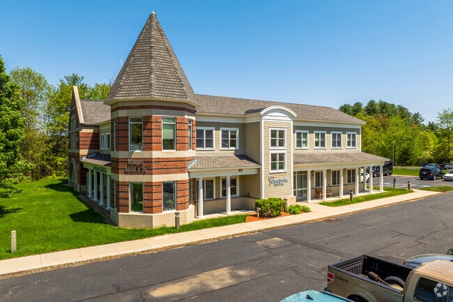
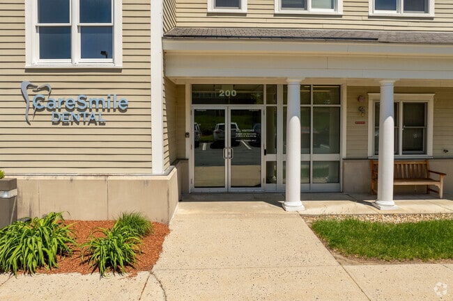
Property Record
200 Ayer Rd, Harvard, MA 01451

Current Lease Availabilities
Property Detail
200 Ayer Rd
HARV-000008-000040-000002
WORCESTER
Commercialbuilding
Massachusetts
B and X Area of moderate flood hazard, usually the area between the limits of the 100-year and 500-year floods.
2
2025
3.83 AC
2025
Fitchburg/Leominster
761402
Boston
16,580 SF
Worcester, MA
NEARBY LISTINGS FOR SALE OR LEASE
DEMOGRAPHICS near 200 Ayer Rd
1 mile
3 mile
5 mile
2025 Total Population
978
13,955
34,665
2030 Population
1,011
14,552
36,157
Pop Growth 2025-2030
+ 3.37%
+ 4.28%
+ 4.30%
Average Age
44
43
43
2025 Total Households
357
5,294
12,666
HH Growth 2025-2030
+ 3.36%
+ 4.61%
+ 4.56%
Median Household Inc
$178,804
$126,501
$136,451
Avg Household Size
2.80
2.40
2.50
2025 Avg HH Vehicles
2.00
2.00
2.00
Median Home Value
$846,036
$601,278
$637,213
Median Year Built
1967
1973
1977
Nearby Places
Map Layers
Map Styles
 Street
 Aerial
Transit
 Traffic
 Biking
Places
Listings with unknown addresses are not visible on the map
- Restaurants
- Banks
- Shops
- Fitness
- Groceries
PUBLIC TRANSPORTATION
COMMUTER RAIL
Ayer (Fitchburg/South Acton Line - Massachusetts Bay Transportation Authority Commuter Rail (Purple Line))
Drive
Walk
Distance
Ayer (Fitchburg/South Acton Line - Massachusetts Bay Transportation Authority Commuter Rail (Purple Line))
6 min
3.0 mi
Shirley (Fitchburg/South Acton Line - Massachusetts Bay Transportation Authority Commuter Rail (Purple Line))
Drive
Walk
Distance
Shirley (Fitchburg/South Acton Line - Massachusetts Bay Transportation Authority Commuter Rail (Purple Line))
11 min
5.7 mi
AIRPORT
Worcester Regional
Drive
Walk
Distance
Worcester Regional
48 min
33.6 mi
Manchester Boston Regional
Drive
Walk
Distance
Manchester Boston Regional
61 min
35.2 mi
Freight Ports
Port of Boston
Drive
Walk
Distance
Port of Boston
55 min
35.7 mi
Nearby Properties
Address
Land Use
TOTAL SIZE
Lot Size
Zoning
Address
Land Use
TOTAL SIZE
Lot Size
Zoning
329,818 SF
55 AC
A1
Address
Land Use
TOTAL SIZE
Lot Size
Zoning
164,000 SF
11 AC
4
Address
Land Use
TOTAL SIZE
Lot Size
Zoning
337,563 SF
21.31 AC
17
Address
Land Use
TOTAL SIZE
Lot Size
Zoning
832,622 SF
43.78 AC
I
Address
Land Use
TOTAL SIZE
Lot Size
Zoning
2,295.68 AC
Address
Land Use
TOTAL SIZE
Lot Size
Zoning
109,921 SF
7.22 AC
21
Address
Land Use
TOTAL SIZE
Lot Size
Zoning
373.10 AC
O
Address
Land Use
TOTAL SIZE
Lot Size
Zoning
353,742 SF
34.89 AC
C
Address
Land Use
TOTAL SIZE
Lot Size
Zoning
398,800 SF
21.92 AC
I
Address
Land Use
TOTAL SIZE
Lot Size
Zoning
214.69 AC
O
Address
Land Use
TOTAL SIZE
Lot Size
Zoning
214.32 AC
4
Address
Land Use
TOTAL SIZE
Lot Size
Zoning
202.78 AC
14
Address
Land Use
TOTAL SIZE
Lot Size
Zoning
210,620 SF
12.97 AC
Address
Land Use
TOTAL SIZE
Lot Size
Zoning
342,309 SF
21.60 AC
I
Address
Land Use
TOTAL SIZE
Lot Size
Zoning
73,772 SF
36.70 AC
4
Address
Land Use
TOTAL SIZE
Lot Size
Zoning
60,968 SF
Address
Land Use
TOTAL SIZE
Lot Size
Zoning
293,250 SF
60.10 AC
LI
Address
Land Use
TOTAL SIZE
Lot Size
Zoning
343,400 SF
20 AC
LI
Address
Land Use
TOTAL SIZE
Lot Size
Zoning
142.59 AC
O
Address
Land Use
TOTAL SIZE
Lot Size
Zoning
216,289 SF
17.54 AC
I
Address
Land Use
TOTAL SIZE
Lot Size
Zoning
66,966 SF
C
Address
Land Use
TOTAL SIZE
Lot Size
Zoning
78,344 SF
7.65 AC
O
Address
Land Use
TOTAL SIZE
Lot Size
Zoning
131 AC
2
Address
Land Use
TOTAL SIZE
Lot Size
Zoning
162,000 SF
19.40 AC
I
Address
Land Use
TOTAL SIZE
Lot Size
Zoning
186,000 SF
16.02 AC
C
Address
Land Use
TOTAL SIZE
Lot Size
Zoning
134,920 SF
26.90 AC
I
Address
Land Use
TOTAL SIZE
Lot Size
Zoning
150,372 SF
15.74 AC
21
Address
Land Use
TOTAL SIZE
Lot Size
Zoning
162,932 SF
19.12 AC
C
Address
Land Use
TOTAL SIZE
Lot Size
Zoning
234,465 SF
16.13 AC
I
Address
Land Use
TOTAL SIZE
Lot Size
Zoning
122,184 SF
8.14 AC
The World's #1 Commercial Real Estate Marketplace
Connect with us
© 2026 CoStar Group
The information above has been obtained from sources believed reliable. While we do not doubt its accuracy we have not verified it and make no guarantee, warranty or representation about it. It is your responsibility to independently confirm its accuracy and completeness. Any projections, opinions, assumptions, or estimates used are for example only and do not represent the current or future performance of the property. The value of this transaction to you depends on tax and other factors which should be evaluated by your tax, financial, and legal advisors. You and your advisors should conduct a careful, independent investigation of the property to determine to your satisfaction the suitability of the property for your needs.