Property Record
200 Beaver Brook Rd, Boxborough, MA 01719
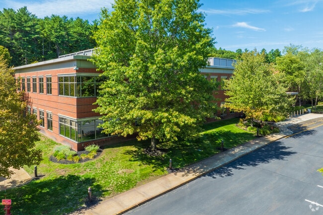

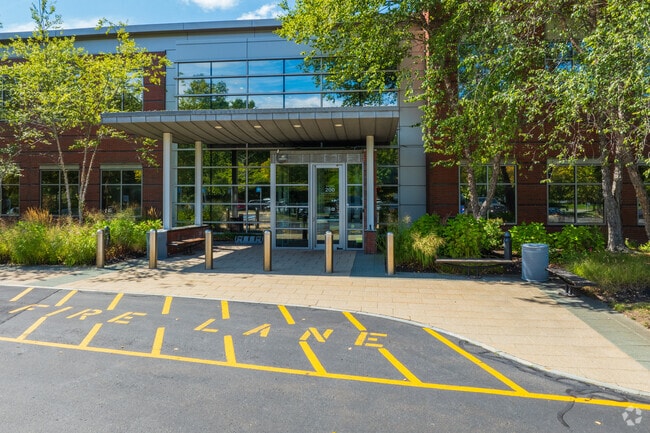
Property Detail
200 Beaver Brook Rd
BOXB-000008-000003
Middlesex
Scientificpharmaceuticalmedicalresearchfacility
Massachusetts
B and X Area of moderate flood hazard, usually the area between the limits of the 100-year and 500-year floods.
8.28 AC
2025
Concord/Maynard
2025
Boston
388100
Boston-Cambridge-Newton, MA-NH
97,210 SF
NEARBY LISTINGS FOR SALE OR LEASE
DEMOGRAPHICS near 200 Beaver Brook Rd
1 mile
3 mile
5 mile
2025 Total Population
1,787
11,396
40,996
2030 Population
1,866
11,827
42,704
Pop Growth 2025-2030
+ 4.42%
+ 3.78%
+ 4.17%
Average Age
42
43
43
2025 Total Households
828
4,400
15,369
HH Growth 2025-2030
+ 4.59%
+ 3.95%
+ 4.36%
Median Household Inc
$117,472
$170,240
$161,284
Avg Household Size
2.20
2.60
2.60
2025 Avg HH Vehicles
2.00
2.00
2.00
Median Home Value
$680,309
$778,430
$725,716
Median Year Built
1976
1977
1975
Nearby Places
Map Layers
Map Styles
 Street
 Aerial
Layers
 Traffic
 Biking
Places
Listings with unknown addresses are not visible on the map
- Restaurants
- Banks
- Shops
- Fitness
- Groceries
PUBLIC TRANSPORTATION
COMMUTER RAIL
Littleton/Route 495 (Fitchburg/South Acton Line - Massachusetts Bay Transportation Authority Commuter Rail (Purple Line))
Drive
Walk
Distance
Littleton/Route 495 (Fitchburg/South Acton Line - Massachusetts Bay Transportation Authority Commuter Rail (Purple Line))
12 min
6.3 mi
South Acton (Fitchburg/South Acton Line - Massachusetts Bay Transportation Authority Commuter Rail (Purple Line))
Drive
Walk
Distance
South Acton (Fitchburg/South Acton Line - Massachusetts Bay Transportation Authority Commuter Rail (Purple Line))
15 min
6.6 mi
AIRPORT
Worcester Regional
Drive
Walk
Distance
Worcester Regional
43 min
29.2 mi
General Edward Lawrence Logan International
Drive
Walk
Distance
General Edward Lawrence Logan International
57 min
32.8 mi
Manchester Boston Regional
Drive
Walk
Distance
Manchester Boston Regional
62 min
40.3 mi
SALE & LEASE HISTORY
LISTING DATE
SALE/LEASE

Aug 10, 2021
For Lease
Nearby Properties
Address
Land Use
TOTAL SIZE
Lot Size
Zoning
Address
Land Use
TOTAL SIZE
Lot Size
Zoning
312,503 SF
54.44 AC
AR
Address
Land Use
TOTAL SIZE
Lot Size
Zoning
2,295.68 AC
Address
Land Use
TOTAL SIZE
Lot Size
Zoning
260,475 SF
70.94 AC
OP
Address
Land Use
TOTAL SIZE
Lot Size
Zoning
143,640 SF
29.44 AC
IA
Address
Land Use
TOTAL SIZE
Lot Size
Zoning
210,620 SF
12.97 AC
Address
Land Use
TOTAL SIZE
Lot Size
Zoning
131,607 SF
36.01 AC
Address
Land Use
TOTAL SIZE
Lot Size
Zoning
110,150 SF
18.44 AC
Address
Land Use
TOTAL SIZE
Lot Size
Zoning
122,184 SF
8.14 AC
Address
Land Use
TOTAL SIZE
Lot Size
Zoning
137,599 SF
21 AC
Address
Land Use
TOTAL SIZE
Lot Size
Zoning
154,436 SF
18.86 AC
IA
Address
Land Use
TOTAL SIZE
Lot Size
Zoning
103,680 SF
9.30 AC
Address
Land Use
TOTAL SIZE
Lot Size
Zoning
71,395 SF
8.37 AC
C
Address
Land Use
TOTAL SIZE
Lot Size
Zoning
98,125 SF
8.97 AC
IA
Address
Land Use
TOTAL SIZE
Lot Size
Zoning
120,612 SF
16.42 AC
Address
Land Use
TOTAL SIZE
Lot Size
Zoning
108,992 SF
23.90 AC
IA
Address
Land Use
TOTAL SIZE
Lot Size
Zoning
102,793 SF
11.56 AC
OP
Address
Land Use
TOTAL SIZE
Lot Size
Zoning
161,597 SF
20.67 AC
IA
Address
Land Use
TOTAL SIZE
Lot Size
Zoning
948 AC
AR
Address
Land Use
TOTAL SIZE
Lot Size
Zoning
101,328 SF
13.97 AC
OP
Address
Land Use
TOTAL SIZE
Lot Size
Zoning
64,142 SF
9.15 AC
Address
Land Use
TOTAL SIZE
Lot Size
Zoning
49,080 SF
2.48 AC
Address
Land Use
TOTAL SIZE
Lot Size
Zoning
95,634 SF
22.16 AC
OP
Address
Land Use
TOTAL SIZE
Lot Size
Zoning
69,338 SF
10 AC
IA
Address
Land Use
TOTAL SIZE
Lot Size
Zoning
100,994 SF
19.54 AC
IA
Address
Land Use
TOTAL SIZE
Lot Size
Zoning
41,916 SF
10.14 AC
AR
Address
Land Use
TOTAL SIZE
Lot Size
Zoning
12,102 SF
108.88 AC
C
Address
Land Use
TOTAL SIZE
Lot Size
Zoning
147,437 SF
18.20 AC
OP
Address
Land Use
TOTAL SIZE
Lot Size
Zoning
59,925 SF
7.06 AC
OP
Address
Land Use
TOTAL SIZE
Lot Size
Zoning
51,340 SF
13.85 AC
C
The World's #1 Commercial Real Estate Marketplace
Connect with us
© 2026 CoStar Group
The information above has been obtained from sources believed reliable. While we do not doubt its accuracy we have not verified it and make no guarantee, warranty or representation about it. It is your responsibility to independently confirm its accuracy and completeness. Any projections, opinions, assumptions, or estimates used are for example only and do not represent the current or future performance of the property. The value of this transaction to you depends on tax and other factors which should be evaluated by your tax, financial, and legal advisors. You and your advisors should conduct a careful, independent investigation of the property to determine to your satisfaction the suitability of the property for your needs.