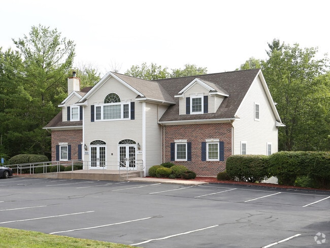
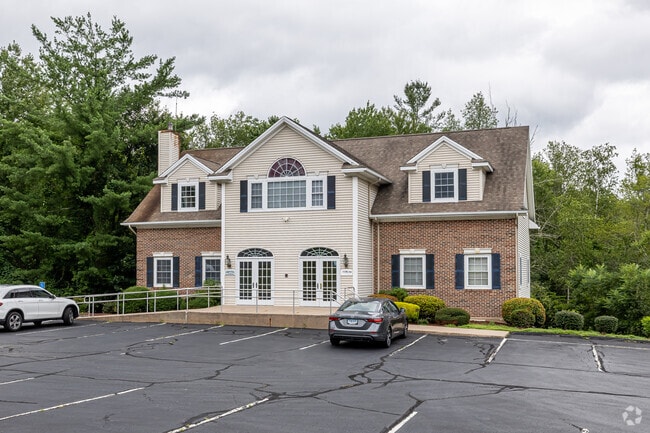
Property Record
200 Birge Park Rd, Harwinton, CT 06791

Save to a Folder
{{folder.Name}}
{{folder.ListingIds.length}} Properties
{{folder.ListingIds.length}} Property
Create a New Folder
Property Detail
200 Birge Park Rd
HARW-000008-000006-000022C
Nw Hills
Commercialbuilding
Connecticut
RS-1
22
2024
5.12 AC
2025
Torrington
298300
Hartford
4,400 SF
Torrington, CT
NEARBY LISTINGS FOR SALE OR LEASE
DEMOGRAPHICS near 200 Birge Park Rd
1 mile
3 mile
5 mile
2025 Total Population
1,312
19,828
41,384
2030 Population
1,317
19,879
41,434
Pop Growth 2025-2030
+ 0.38%
+ 0.26%
+ 0.12%
Average Age
45
44
43
2025 Total Households
552
8,687
17,652
HH Growth 2025-2030
+ 0.54%
+ 0.35%
+ 0.16%
Median Household Inc
$91,486
$74,484
$78,008
Avg Household Size
2.40
2.20
2.30
2025 Avg HH Vehicles
2.00
2.00
2.00
Median Home Value
$330,423
$239,157
$248,875
Median Year Built
1964
1960
1961
Nearby Places
Map Layers
Map Styles
 Street
 Aerial
Layers
 Traffic
 Biking
Places
Listings with unknown addresses are not visible on the map
- Restaurants
- Banks
- Shops
- Fitness
- Groceries
PUBLIC TRANSPORTATION
AIRPORT
Bradley International
Drive
Walk
Distance
Bradley International
59 min
33.9 mi
Freight Ports
Port of New Haven
Drive
Walk
Distance
Port of New Haven
65 min
45.2 mi
Nearby Properties
Address
Land Use
TOTAL SIZE
Lot Size
Zoning
Address
Land Use
TOTAL SIZE
Lot Size
Zoning
10.80 AC
R10S
Address
Land Use
TOTAL SIZE
Lot Size
Zoning
142,840 SF
13.80 AC
R6
Address
Land Use
TOTAL SIZE
Lot Size
Zoning
128,711 SF
18.50 AC
LB
Address
Land Use
TOTAL SIZE
Lot Size
Zoning
13,576 SF
12.80 AC
R10
Address
Land Use
TOTAL SIZE
Lot Size
Zoning
42,676 SF
3.19 AC
R6
Address
Land Use
TOTAL SIZE
Lot Size
Zoning
95,978 SF
CIR
Address
Land Use
TOTAL SIZE
Lot Size
Zoning
68,013 SF
9.83 AC
R10S
Address
Land Use
TOTAL SIZE
Lot Size
Zoning
124,360 SF
4.30 AC
DD
Address
Land Use
TOTAL SIZE
Lot Size
Zoning
56,699 SF
11.41 AC
LB
Address
Land Use
TOTAL SIZE
Lot Size
Zoning
68,192 SF
1.76 AC
DD
Address
Land Use
TOTAL SIZE
Lot Size
Zoning
63,735 SF
3.32 AC
CIR
Address
Land Use
TOTAL SIZE
Lot Size
Zoning
25,393 SF
12.60 AC
R10S
Address
Land Use
TOTAL SIZE
Lot Size
Zoning
131,925 SF
12.51 AC
DD
Address
Land Use
TOTAL SIZE
Lot Size
Zoning
93,608 SF
25.40 AC
B
Address
Land Use
TOTAL SIZE
Lot Size
Zoning
15.80 AC
R6
Address
Land Use
TOTAL SIZE
Lot Size
Zoning
68,160 SF
2.31 AC
LB
Address
Land Use
TOTAL SIZE
Lot Size
Zoning
5.17 AC
LB
Address
Land Use
TOTAL SIZE
Lot Size
Zoning
7,200 SF
0.27 AC
DD
Address
Land Use
TOTAL SIZE
Lot Size
Zoning
1 AC
DD
Address
Land Use
TOTAL SIZE
Lot Size
Zoning
9.39 AC
LB
Address
Land Use
TOTAL SIZE
Lot Size
Zoning
36.55 AC
CIR
Address
Land Use
TOTAL SIZE
Lot Size
Zoning
4.70 AC
I
Address
Land Use
TOTAL SIZE
Lot Size
Zoning
59,670 SF
4.31 AC
R6
Address
Land Use
TOTAL SIZE
Lot Size
Zoning
57,875 SF
21.83 AC
CRA-2
Address
Land Use
TOTAL SIZE
Lot Size
Zoning
8.10 AC
R6
Address
Land Use
TOTAL SIZE
Lot Size
Zoning
21,654 SF
0.53 AC
DD
Address
Land Use
TOTAL SIZE
Lot Size
Zoning
20,873 SF
0.54 AC
DD
Address
Land Use
TOTAL SIZE
Lot Size
Zoning
8.13 AC
LB
Address
Land Use
TOTAL SIZE
Lot Size
Zoning
14,405 SF
1.50 AC
DD
Address
Land Use
TOTAL SIZE
Lot Size
Zoning
42,771 SF
1.40 AC
DD
The World's #1 Commercial Real Estate Marketplace
Connect with us
© 2026 CoStar Group
The information above has been obtained from sources believed reliable. While we do not doubt its accuracy we have not verified it and make no guarantee, warranty or representation about it. It is your responsibility to independently confirm its accuracy and completeness. Any projections, opinions, assumptions, or estimates used are for example only and do not represent the current or future performance of the property. The value of this transaction to you depends on tax and other factors which should be evaluated by your tax, financial, and legal advisors. You and your advisors should conduct a careful, independent investigation of the property to determine to your satisfaction the suitability of the property for your needs.