Property Record
200 Blanket Ln, Elkin, NC 28621

Save to a Folder
{{folder.Name}}
{{folder.ListingIds.length}} Properties
{{folder.ListingIds.length}} Property
Create a New Folder
Property Detail
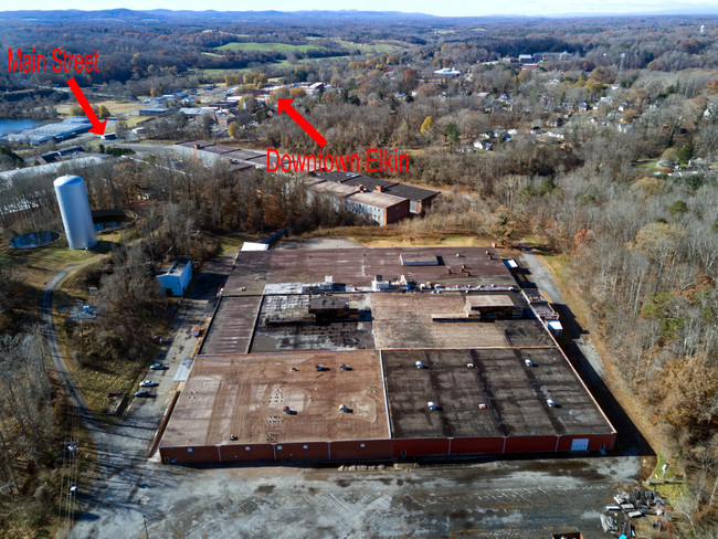
200 Blanket Ln
4951-11-65-1004
PB 35 PGS 29-30
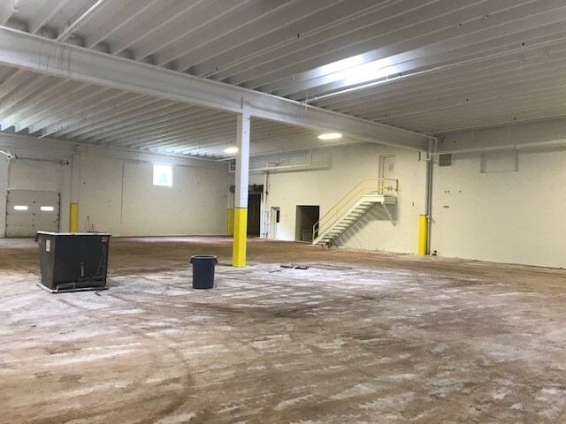
Manufacturinglight
Surry
M1
North Carolina
B and X Area of moderate flood hazard, usually the area between the limits of the 100-year and 500-year floods.
20.55 AC
2025
Hickory/Morganton
2025
Other Market Areas
930901
Mount Airy, NC
179,520 SF
NEARBY LISTINGS FOR SALE OR LEASE
-
-
View all Elkin listings for sale on LoopNet.com
DEMOGRAPHICS near 200 Blanket Ln
1 mile
3 mile
5 mile
2025 Total Population
2,122
10,056
15,010
2030 Population
2,166
10,235
15,242
Pop Growth 2025-2030
+ 2.07%
+ 1.78%
+ 1.55%
Average Age
46
43
44
2025 Total Households
917
4,311
6,402
HH Growth 2025-2030
+ 2.18%
+ 1.83%
+ 1.58%
Median Household Inc
$57,045
$56,184
$60,058
Avg Household Size
2.20
2.30
2.30
2025 Avg HH Vehicles
2.00
2.00
2.00
Median Home Value
$188,888
$161,544
$162,842
Median Year Built
1965
1967
1969
Nearby Places
Map Layers
Map Styles
 Street
 Aerial
Layers
 Traffic
 Biking
Places
Listings with unknown addresses are not visible on the map
- Restaurants
- Banks
- Shops
- Fitness
- Groceries
SALE & LEASE HISTORY
LISTING DATE
SALE/LEASE

Nov 25, 2019
For Sale
Feb 02, 2018
For Lease
Feb 01, 2021
For Sale
Nearby Properties
Address
Land Use
TOTAL SIZE
Lot Size
Zoning
Address
Land Use
TOTAL SIZE
Lot Size
Zoning
155,096 SF
149.94 AC
MA
Address
Land Use
TOTAL SIZE
Lot Size
Zoning
666,492 SF
61.07 AC
Address
Land Use
TOTAL SIZE
Lot Size
Zoning
217,774 SF
39.92 AC
HB
Address
Land Use
TOTAL SIZE
Lot Size
Zoning
94,923 SF
18.31 AC
MDR
Address
Land Use
TOTAL SIZE
Lot Size
Zoning
415,005 SF
37.38 AC
M2
Address
Land Use
TOTAL SIZE
Lot Size
Zoning
6,050 SF
11.80 AC
MA
Address
Land Use
TOTAL SIZE
Lot Size
Zoning
57,895 SF
1.34 AC
B2
Address
Land Use
TOTAL SIZE
Lot Size
Zoning
69,411 SF
18.99 AC
MA
Address
Land Use
TOTAL SIZE
Lot Size
Zoning
117,278 SF
17.06 AC
B2
Address
Land Use
TOTAL SIZE
Lot Size
Zoning
69,396 SF
9 AC
R12
Address
Land Use
TOTAL SIZE
Lot Size
Zoning
21,714 SF
1.90 AC
MDR
Address
Land Use
TOTAL SIZE
Lot Size
Zoning
46,128 SF
5.09 AC
MA
Address
Land Use
TOTAL SIZE
Lot Size
Zoning
404,100 SF
51.83 AC
M1
Address
Land Use
TOTAL SIZE
Lot Size
Zoning
23,062 SF
12.87 AC
LDR
Address
Land Use
TOTAL SIZE
Lot Size
Zoning
720 SF
13.71 AC
HDMF
Address
Land Use
TOTAL SIZE
Lot Size
Zoning
52,248 SF
2.76 AC
Address
Land Use
TOTAL SIZE
Lot Size
Zoning
1,760 SF
8.17 AC
B2
Address
Land Use
TOTAL SIZE
Lot Size
Zoning
40,640 SF
8.87 AC
B2
Address
Land Use
TOTAL SIZE
Lot Size
Zoning
30,980 SF
5.75 AC
B2
Address
Land Use
TOTAL SIZE
Lot Size
Zoning
14,784 SF
2.17 AC
B2
Address
Land Use
TOTAL SIZE
Lot Size
Zoning
34,556 SF
7.29 AC
HB
Address
Land Use
TOTAL SIZE
Lot Size
Zoning
32,940 SF
6.15 AC
B1
Address
Land Use
TOTAL SIZE
Lot Size
Zoning
51,255 SF
19.15 AC
HB
Address
Land Use
TOTAL SIZE
Lot Size
Zoning
9,159 SF
6.61 AC
B2
Address
Land Use
TOTAL SIZE
Lot Size
Zoning
35,055 SF
3.28 AC
Address
Land Use
TOTAL SIZE
Lot Size
Zoning
44,000 SF
5.01 AC
Address
Land Use
TOTAL SIZE
Lot Size
Zoning
18,674 SF
10 AC
R8
Address
Land Use
TOTAL SIZE
Lot Size
Zoning
17,272 SF
6.62 AC
R20
Address
Land Use
TOTAL SIZE
Lot Size
Zoning
6,814 SF
4.54 AC
HB
Address
Land Use
TOTAL SIZE
Lot Size
Zoning
18,274 SF
2.13 AC
HB
The World's #1 Commercial Real Estate Marketplace
Connect with us
© 2026 CoStar Group
The information above has been obtained from sources believed reliable. While we do not doubt its accuracy we have not verified it and make no guarantee, warranty or representation about it. It is your responsibility to independently confirm its accuracy and completeness. Any projections, opinions, assumptions, or estimates used are for example only and do not represent the current or future performance of the property. The value of this transaction to you depends on tax and other factors which should be evaluated by your tax, financial, and legal advisors. You and your advisors should conduct a careful, independent investigation of the property to determine to your satisfaction the suitability of the property for your needs.