Property Record
200 Boardwalk Way, Mineral, VA 23117
NEARBY LISTINGS FOR SALE OR LEASE
-
-
View all Mineral listings for sale on LoopNet.com
Property Detail
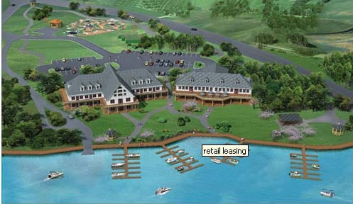
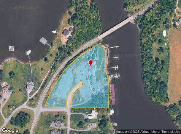
200 Boardwalk Way
Richmond VA
Stonewall Estates
16-9-25
STONEWALL ESTATES PLAT 1873/268 SEQ 10 LOT 25 DB 1199/140 5.942 AC
Commercialnec
Louisa
AE
Virginia
51177C0300D
25
2024
5.94 AC
2025
Louisa County
950202
DEMOGRAPHICS near 200 Boardwalk Way
1 Mile
3 Mile
5 Mile
2024 Total Population
539
3,705
6,899
2029 Population
638
4,358
8,104
Pop Growth 2024-2029
+ 18.37%
+ 17.62%
+ 17.47%
Average Age
47
47
47
2024 Total Households
227
1,533
2,851
HH Growth 2024-2029
+ 18.50%
+ 17.61%
+ 17.43%
Median Household Inc
$95,356
$96,627
$93,304
Avg Household Size
2.40
2.40
2.40
2024 Avg HH Vehicles
3.00
3.00
3.00
Median Home Value
$346,590
$372,686
$366,047
Median Year Built
1997
1997
1996
Nearby Places
Map Layers
Map Styles
 Street
 Aerial
- Restaurants
- Banks
- Shops
- Fitness
- Groceries
PUBLIC TRANSPORTATION
AIRPORT
Charlottesville-Albemarle
DRIVE
WALK
Distance
Charlottesville-Albemarle
65 min
47.6 mi
Freight Ports
Virginia Port Authority - Richmond
DRIVE
WALK
Distance
Virginia Port Authority - Richmond
1 min
52.8 mi
SALE & LEASE HISTORY
LISTING DATE
SALE/LEASE

Sep 24, 2016
For Sale
Nearby Properties
Address
Land Use
TOTAL SIZE
Lot Size
Zoning
Address
Land Use
TOTAL SIZE
Lot Size
Zoning
5.94 AC
C2
Address
Land Use
TOTAL SIZE
Lot Size
Zoning
3,211 SF
260.55 AC
RA - AGRIC
Address
Land Use
TOTAL SIZE
Lot Size
Zoning
1,936 SF
137.24 AC
PR3
Address
Land Use
TOTAL SIZE
Lot Size
Zoning
1,344 SF
177.17 AC
MZ - MULTI
Address
Land Use
TOTAL SIZE
Lot Size
Zoning
1,738 SF
61.28 AC
RA - AGRIC
Address
Land Use
TOTAL SIZE
Lot Size
Zoning
20,827 SF
13.31 AC
A2
Address
Land Use
TOTAL SIZE
Lot Size
Zoning
2,246 SF
131.82 AC
RA - AGRIC
Address
Land Use
TOTAL SIZE
Lot Size
Zoning
1,008 SF
82.15 AC
RA - AGRIC
Address
Land Use
TOTAL SIZE
Lot Size
Zoning
1,456 SF
30.66 AC
RA - AGRIC
Address
Land Use
TOTAL SIZE
Lot Size
Zoning
2,296 SF
83.89 AC
RA - AGRIC
Address
Land Use
TOTAL SIZE
Lot Size
Zoning
107.72 AC
MZ - MULTI
Address
Land Use
TOTAL SIZE
Lot Size
Zoning
164.52 AC
R2
Address
Land Use
TOTAL SIZE
Lot Size
Zoning
1,344 SF
162.22 AC
RA - AGRIC
Address
Land Use
TOTAL SIZE
Lot Size
Zoning
134.21 AC
RA - AGRIC
Address
Land Use
TOTAL SIZE
Lot Size
Zoning
117.43 AC
RA - AGRIC
Address
Land Use
TOTAL SIZE
Lot Size
Zoning
2,350 SF
35.82 AC
R2
Address
Land Use
TOTAL SIZE
Lot Size
Zoning
5,092 SF
5.27 AC
R2
Address
Land Use
TOTAL SIZE
Lot Size
Zoning
112.64 AC
C2
Address
Land Use
TOTAL SIZE
Lot Size
Zoning
1,930 SF
44.81 AC
RA - AGRIC
Address
Land Use
TOTAL SIZE
Lot Size
Zoning
1,421 SF
57.76 AC
RA - AGRIC
Address
Land Use
TOTAL SIZE
Lot Size
Zoning
1,845 SF
30.44 AC
RA - AGRIC
Address
Land Use
TOTAL SIZE
Lot Size
Zoning
96.09 AC
R2
Address
Land Use
TOTAL SIZE
Lot Size
Zoning
2,494 SF
76.50 AC
RA - AGRIC
Address
Land Use
TOTAL SIZE
Lot Size
Zoning
2,576 SF
162.47 AC
RA - AGRIC
Address
Land Use
TOTAL SIZE
Lot Size
Zoning
3,270 SF
30.80 AC
RA - AGRIC
Address
Land Use
TOTAL SIZE
Lot Size
Zoning
2,206 SF
20 AC
RA - AGRIC
Address
Land Use
TOTAL SIZE
Lot Size
Zoning
6.14 AC
RR - RESID
Address
Land Use
TOTAL SIZE
Lot Size
Zoning
1.14 AC
PUD
Address
Land Use
TOTAL SIZE
Lot Size
Zoning
5.05 AC
RR - RESID
Address
Land Use
TOTAL SIZE
Lot Size
Zoning
71.43 AC
MZ - MULTI
The World's #1 Commercial Real Estate Marketplace
Connect with us
© 2026 CoStar Group
The information above has been obtained from sources believed reliable. While we do not doubt its accuracy we have not verified it and make no guarantee, warranty or representation about it. It is your responsibility to independently confirm its accuracy and completeness. Any projections, opinions, assumptions, or estimates used are for example only and do not represent the current or future performance of the property. The value of this transaction to you depends on tax and other factors which should be evaluated by your tax, financial, and legal advisors. You and your advisors should conduct a careful, independent investigation of the property to determine to your satisfaction the suitability of the property for your needs.