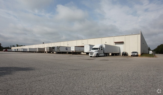
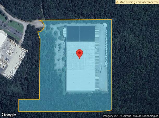
Property Record
200 Boyds Crossing Rd, Griffin, GA 30224
NEARBY LISTINGS FOR SALE OR LEASE
Property Detail
200 Boyds Crossing Rd
Atlanta-Sandy Springs-Roswell, GA
Norcom
125B-01-007
LT 10 BOYD'S CROSSING PB 23/170
Officebuilding
Spalding
X
Georgia
13255C0205E
10
2024
23.27 AC
2024
S Clayton/Henry Cnty
161000
Atlanta
293,260 SF
DEMOGRAPHICS near 200 Boyds Crossing Rd
1 Mile
3 Mile
5 Mile
2024 Total Population
418
12,089
37,422
2029 Population
442
12,793
39,882
Pop Growth 2024-2029
+ 5.74%
+ 5.82%
+ 6.57%
Average Age
40
40
39
2024 Total Households
153
4,631
14,232
HH Growth 2024-2029
+ 5.88%
+ 5.70%
+ 6.49%
Median Household Inc
$64,838
$63,479
$47,317
Avg Household Size
2.70
2.60
2.60
2024 Avg HH Vehicles
2.00
2.00
2.00
Median Home Value
$245,555
$193,689
$181,455
Median Year Built
1986
1977
1976
Nearby Places
Map Layers
Map Styles
 Street
 Aerial
- Restaurants
- Banks
- Shops
- Fitness
- Groceries
PUBLIC TRANSPORTATION
AIRPORT
Hartsfield - Jackson Atlanta International
DRIVE
WALK
Distance
Hartsfield - Jackson Atlanta International
60 min
41.1 mi
Nearby Properties
Address
Land Use
TOTAL SIZE
Lot Size
Zoning
Address
Land Use
TOTAL SIZE
Lot Size
Zoning
303,594 SF
58.69 AC
PDD
Address
Land Use
TOTAL SIZE
Lot Size
Zoning
367,793 SF
223.84 AC
C2
Address
Land Use
TOTAL SIZE
Lot Size
Zoning
13,392 SF
31.70 AC
Address
Land Use
TOTAL SIZE
Lot Size
Zoning
305,123 SF
37 AC
C2
Address
Land Use
TOTAL SIZE
Lot Size
Zoning
16,394 SF
24.32 AC
LDRB
Address
Land Use
TOTAL SIZE
Lot Size
Zoning
73.71 AC
AR1
Address
Land Use
TOTAL SIZE
Lot Size
Zoning
216,242 SF
15.21 AC
C2
Address
Land Use
TOTAL SIZE
Lot Size
Zoning
92,331 SF
29.84 AC
C2
Address
Land Use
TOTAL SIZE
Lot Size
Zoning
39,105 SF
33.98 AC
PDD
Address
Land Use
TOTAL SIZE
Lot Size
Zoning
84,105 SF
17 AC
AR1
Address
Land Use
TOTAL SIZE
Lot Size
Zoning
16 AC
PCD
Address
Land Use
TOTAL SIZE
Lot Size
Zoning
48,856 SF
35.46 AC
PDD
Address
Land Use
TOTAL SIZE
Lot Size
Zoning
72,876 SF
16.23 AC
PDD
Address
Land Use
TOTAL SIZE
Lot Size
Zoning
39,105 SF
33.98 AC
PDD
Address
Land Use
TOTAL SIZE
Lot Size
Zoning
48,856 SF
33.47 AC
PDD
Address
Land Use
TOTAL SIZE
Lot Size
Zoning
62,748 SF
22 AC
PDD
Address
Land Use
TOTAL SIZE
Lot Size
Zoning
65,058 SF
3.74 AC
Address
Land Use
TOTAL SIZE
Lot Size
Zoning
205,953 SF
17.81 AC
PID
Address
Land Use
TOTAL SIZE
Lot Size
Zoning
203,804 SF
10.76 AC
C2
Address
Land Use
TOTAL SIZE
Lot Size
Zoning
61,517 SF
12.96 AC
PCD
Address
Land Use
TOTAL SIZE
Lot Size
Zoning
72,056 SF
11.89 AC
C2
Address
Land Use
TOTAL SIZE
Lot Size
Zoning
303,594 SF
58.69 AC
PDD
Address
Land Use
TOTAL SIZE
Lot Size
Zoning
203,291 SF
19.83 AC
PID
Address
Land Use
TOTAL SIZE
Lot Size
Zoning
142,875 SF
20 AC
PID
Address
Land Use
TOTAL SIZE
Lot Size
Zoning
123,401 SF
26.43 AC
PID
Address
Land Use
TOTAL SIZE
Lot Size
Zoning
108,086 SF
29.23 AC
C-2
Address
Land Use
TOTAL SIZE
Lot Size
Zoning
20,510 SF
42.32 AC
Address
Land Use
TOTAL SIZE
Lot Size
Zoning
137,279 SF
10.84 AC
PID
Address
Land Use
TOTAL SIZE
Lot Size
Zoning
37,681 SF
8.40 AC
C-1C
The World's #1 Commercial Real Estate Marketplace
Connect with us
© 2026 CoStar Group
The information above has been obtained from sources believed reliable. While we do not doubt its accuracy we have not verified it and make no guarantee, warranty or representation about it. It is your responsibility to independently confirm its accuracy and completeness. Any projections, opinions, assumptions, or estimates used are for example only and do not represent the current or future performance of the property. The value of this transaction to you depends on tax and other factors which should be evaluated by your tax, financial, and legal advisors. You and your advisors should conduct a careful, independent investigation of the property to determine to your satisfaction the suitability of the property for your needs.