Property Record
200 Cabot Blvd E, Langhorne, PA 19047
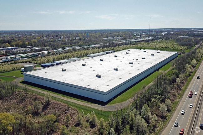

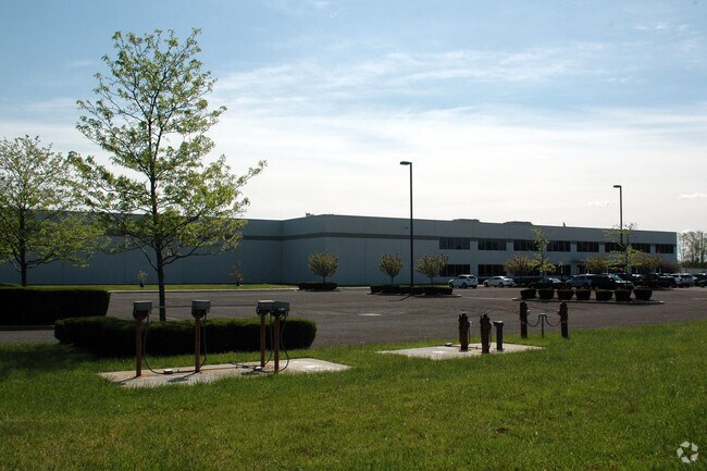
Property Detail
200 Cabot Blvd E
Philadelphia-Camden-Wilmington, PA-NJ-DE-MD
43.54AC LOT# 4 GENERAL MOTORS PLAN 176 ON CABOT BLVD EXT
13-003-009-013
Bucks
Warehouse
Pennsylvania
LI
4
B and X Area of moderate flood hazard, usually the area between the limits of the 100-year and 500-year floods.
43.54 AC
2024
Bucks
2025
Philadelphia
105801
NEARBY LISTINGS FOR SALE OR LEASE
DEMOGRAPHICS near 200 Cabot Blvd E
1 mile
3 mile
5 mile
2025 Total Population
6,580
81,682
232,716
2030 Population
6,556
81,943
236,073
Pop Growth 2025-2030
(0.36%)
+ 0.32%
+ 1.44%
Average Age
42
43
41
2025 Total Households
2,309
31,287
87,170
HH Growth 2025-2030
(0.39%)
+ 0.29%
+ 1.57%
Median Household Inc
$110,745
$112,423
$85,728
Avg Household Size
2.80
2.60
2.60
2025 Avg HH Vehicles
2.00
2.00
2.00
Median Home Value
$419,752
$400,953
$371,092
Median Year Built
1959
1967
1958
Nearby Places
Map Layers
Map Styles
 Street
 Aerial
Layers
 Traffic
 Biking
Places
Listings with unknown addresses are not visible on the map
- Restaurants
- Banks
- Shops
- Fitness
- Groceries
PUBLIC TRANSPORTATION
COMMUTER RAIL
Yardley (R3 - Southeastern Pennsylvania Transportation Authority Regional Rail (SEPTA Regional Rail))
Drive
Walk
Distance
Yardley (R3 - Southeastern Pennsylvania Transportation Authority Regional Rail (SEPTA Regional Rail))
10 min
4.3 mi
Woodbourne (R3 - Southeastern Pennsylvania Transportation Authority Regional Rail (SEPTA Regional Rail))
Drive
Walk
Distance
Woodbourne (R3 - Southeastern Pennsylvania Transportation Authority Regional Rail (SEPTA Regional Rail))
6 min
4.4 mi
AIRPORT
Trenton Mercer
Drive
Walk
Distance
Trenton Mercer
18 min
9.9 mi
Freight Ports
Port of Philadelphia
Drive
Walk
Distance
Port of Philadelphia
37 min
25.7 mi
Nearby Properties
Address
Land Use
TOTAL SIZE
Lot Size
Zoning
Address
Land Use
TOTAL SIZE
Lot Size
Zoning
356,045 SF
7.67 AC
MOZ1
Address
Land Use
TOTAL SIZE
Lot Size
Zoning
4,982 SF
39 AC
C
Address
Land Use
TOTAL SIZE
Lot Size
Zoning
35,542 SF
27.89 AC
NC
Address
Land Use
TOTAL SIZE
Lot Size
Zoning
10,350 SF
35.55 AC
R4
Address
Land Use
TOTAL SIZE
Lot Size
Zoning
396,000 SF
36.71 AC
PIP
Address
Land Use
TOTAL SIZE
Lot Size
Zoning
21.78 AC
R4
Address
Land Use
TOTAL SIZE
Lot Size
Zoning
2,108,894 SF
95.90 AC
LI
Address
Land Use
TOTAL SIZE
Lot Size
Zoning
282,799 SF
24.77 AC
GB
Address
Land Use
TOTAL SIZE
Lot Size
Zoning
730,540 SF
82.69 AC
GB
Address
Land Use
TOTAL SIZE
Lot Size
Zoning
43.54 AC
LI
Address
Land Use
TOTAL SIZE
Lot Size
Zoning
132,780 SF
11.09 AC
R3
Address
Land Use
TOTAL SIZE
Lot Size
Zoning
3,490 SF
15.80 AC
R1
Address
Land Use
TOTAL SIZE
Lot Size
Zoning
148,444 SF
24.06 AC
HR
Address
Land Use
TOTAL SIZE
Lot Size
Zoning
100,736 SF
25 AC
C 1
Address
Land Use
TOTAL SIZE
Lot Size
Zoning
92,479 SF
11.48 AC
Address
Land Use
TOTAL SIZE
Lot Size
Zoning
99,124 SF
10.14 AC
C
Address
Land Use
TOTAL SIZE
Lot Size
Zoning
116,120 SF
2.70 AC
MZO1
Address
Land Use
TOTAL SIZE
Lot Size
Zoning
19,424 SF
5.89 AC
HC
Address
Land Use
TOTAL SIZE
Lot Size
Zoning
80,071 SF
17.46 AC
R2
Address
Land Use
TOTAL SIZE
Lot Size
Zoning
33,528 SF
5.38 AC
P
Address
Land Use
TOTAL SIZE
Lot Size
Zoning
134,750 SF
12.87 AC
C
Address
Land Use
TOTAL SIZE
Lot Size
Zoning
102,908 SF
9.11 AC
C
Address
Land Use
TOTAL SIZE
Lot Size
Zoning
91,910 SF
6.05 AC
GB
Address
Land Use
TOTAL SIZE
Lot Size
Zoning
299,192 SF
20.28 AC
PIP
Address
Land Use
TOTAL SIZE
Lot Size
Zoning
34,049 SF
14.68 AC
AO
Address
Land Use
TOTAL SIZE
Lot Size
Zoning
19,504 SF
11.05 AC
A-O
Address
Land Use
TOTAL SIZE
Lot Size
Zoning
142,008 SF
15.22 AC
GB
Address
Land Use
TOTAL SIZE
Lot Size
Zoning
227,460 SF
18.79 AC
PIP
Address
Land Use
TOTAL SIZE
Lot Size
Zoning
115,648 SF
9.51 AC
PIP
Address
Land Use
TOTAL SIZE
Lot Size
Zoning
10,000 SF
101.71 AC
LI
The World's #1 Commercial Real Estate Marketplace
Connect with us
© 2026 CoStar Group
The information above has been obtained from sources believed reliable. While we do not doubt its accuracy we have not verified it and make no guarantee, warranty or representation about it. It is your responsibility to independently confirm its accuracy and completeness. Any projections, opinions, assumptions, or estimates used are for example only and do not represent the current or future performance of the property. The value of this transaction to you depends on tax and other factors which should be evaluated by your tax, financial, and legal advisors. You and your advisors should conduct a careful, independent investigation of the property to determine to your satisfaction the suitability of the property for your needs.