Property Record
200 Cardinal Rd, Hyde Park, NY 12538


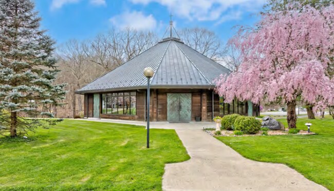
This Property Is For Sale
NEARBY LISTINGS FOR SALE OR LEASE
-
-
View all Hyde Park listings for sale on LoopNet.com
Property Detail
200 Cardinal Rd
133200-6265-03-417423-0000
75.08 AC (D) 1956 0544 1688 0291
Recreationalentertainmentgeneral
Dutchess
X
New York
36027C0267E
417
0
75.08 AC
2024
Fishkill
070102
Westchester/So Connecticut
62,100 SF
Kiryas Joel-Poughkeepsie-Newburgh, NY
DEMOGRAPHICS near 200 Cardinal Rd
1 Mile
3 Mile
5 Mile
2024 Total Population
1,170
11,978
32,312
2029 Population
1,172
11,986
32,296
Pop Growth 2024-2029
+ 0.17%
+ 0.07%
(0.05%)
Average Age
47
44
42
2024 Total Households
455
4,802
12,365
HH Growth 2024-2029
+ 0.22%
+ 0.04%
(0.09%)
Median Household Inc
$81,731
$84,916
$85,085
Avg Household Size
2.40
2.40
2.40
2024 Avg HH Vehicles
2.00
2.00
2.00
Median Home Value
$265,841
$279,990
$289,926
Median Year Built
1973
1970
1971
Nearby Places
Map Layers
Map Styles
 Street
 Aerial
- Restaurants
- Banks
- Shops
- Fitness
- Groceries
PUBLIC TRANSPORTATION
COMMUTER RAIL
Poughkeepsie Station (Hudson Line - Metro-North Commuter Railroad Company (Metro-North))
DRIVE
WALK
Distance
Poughkeepsie Station (Hudson Line - Metro-North Commuter Railroad Company (Metro-North))
18 min
9.6 mi
AIRPORT
New York Stewart International
DRIVE
WALK
Distance
New York Stewart International
51 min
33.1 mi
Freight Ports
Albany, NY Port
DRIVE
WALK
Distance
Albany, NY Port
97 min
65.1 mi
Nearby Properties
Address
Land Use
TOTAL SIZE
Lot Size
Zoning
Address
Land Use
TOTAL SIZE
Lot Size
Zoning
250,645 SF
65 AC
GB
Address
Land Use
TOTAL SIZE
Lot Size
Zoning
169,527 SF
56.30 AC
N
Address
Land Use
TOTAL SIZE
Lot Size
Zoning
64,945 SF
104.77 AC
GB
Address
Land Use
TOTAL SIZE
Lot Size
Zoning
46,148 SF
22.90 AC
RA
Address
Land Use
TOTAL SIZE
Lot Size
Zoning
21,464 SF
7.69 AC
EPBD
Address
Land Use
TOTAL SIZE
Lot Size
Zoning
123,407 SF
7.71 AC
NC
Address
Land Use
TOTAL SIZE
Lot Size
Zoning
11,483 SF
15.25 AC
NC
Address
Land Use
TOTAL SIZE
Lot Size
Zoning
17,531 SF
176.08 AC
GB
Address
Land Use
TOTAL SIZE
Lot Size
Zoning
52,509 SF
14.28 AC
TCHD
Address
Land Use
TOTAL SIZE
Lot Size
Zoning
5,192 SF
88.89 AC
AR3A
Address
Land Use
TOTAL SIZE
Lot Size
Zoning
25.01 AC
R40
Address
Land Use
TOTAL SIZE
Lot Size
Zoning
17,982 SF
21.36 AC
EPBD
Address
Land Use
TOTAL SIZE
Lot Size
Zoning
13,908 SF
11.86 AC
EPBD
Address
Land Use
TOTAL SIZE
Lot Size
Zoning
59,233 SF
7 AC
GB
Address
Land Use
TOTAL SIZE
Lot Size
Zoning
53,412 SF
7.50 AC
NC
Address
Land Use
TOTAL SIZE
Lot Size
Zoning
23,422 SF
3.50 AC
EPBD
Address
Land Use
TOTAL SIZE
Lot Size
Zoning
20,796 SF
28.84 AC
GB
Address
Land Use
TOTAL SIZE
Lot Size
Zoning
22,736 SF
8 AC
GB
Address
Land Use
TOTAL SIZE
Lot Size
Zoning
6,644 SF
105.46 AC
RA
Address
Land Use
TOTAL SIZE
Lot Size
Zoning
2,728 SF
149.30 AC
RA
Address
Land Use
TOTAL SIZE
Lot Size
Zoning
5,753 SF
10.64 AC
AR5A
Address
Land Use
TOTAL SIZE
Lot Size
Zoning
1,336 SF
95.65 AC
RA
Address
Land Use
TOTAL SIZE
Lot Size
Zoning
10,028 SF
76.90 AC
RR
Address
Land Use
TOTAL SIZE
Lot Size
Zoning
3.67 AC
N
Address
Land Use
TOTAL SIZE
Lot Size
Zoning
4,384 SF
103.20 AC
RA
Address
Land Use
TOTAL SIZE
Lot Size
Zoning
4,388 SF
5.07 AC
RA
Address
Land Use
TOTAL SIZE
Lot Size
Zoning
600 SF
10.21 AC
N
Address
Land Use
TOTAL SIZE
Lot Size
Zoning
90.32 AC
RA
Address
Land Use
TOTAL SIZE
Lot Size
Zoning
19.11 AC
The World's #1 Commercial Real Estate Marketplace
Connect with us
© 2026 CoStar Group
The information above has been obtained from sources believed reliable. While we do not doubt its accuracy we have not verified it and make no guarantee, warranty or representation about it. It is your responsibility to independently confirm its accuracy and completeness. Any projections, opinions, assumptions, or estimates used are for example only and do not represent the current or future performance of the property. The value of this transaction to you depends on tax and other factors which should be evaluated by your tax, financial, and legal advisors. You and your advisors should conduct a careful, independent investigation of the property to determine to your satisfaction the suitability of the property for your needs.