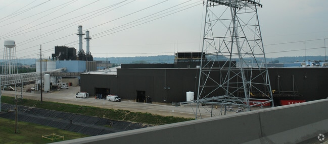
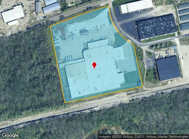
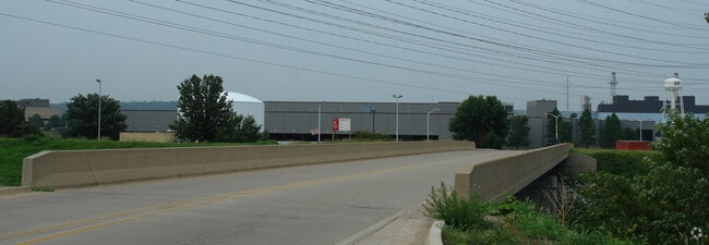
Property Record
200 Carver Ln, East Peoria, IL 61611
NEARBY LISTINGS FOR SALE OR LEASE
Property Detail
200 Carver Ln
01-01-35-102-001
SEC 35 T26N R4W TRACT I NW 1/4 12.778 AC
Storebuilding
Tazewell
X
Illinois
17179C0045E
22.25 AC
2023
East Peoria
2024
Peoria
020100
Peoria, IL
208,914 SF
DEMOGRAPHICS near 200 Carver Ln
1 Mile
3 Mile
5 Mile
2024 Total Population
1,829
57,958
117,401
2029 Population
1,807
57,719
115,711
Pop Growth 2024-2029
(1.20%)
(0.41%)
(1.44%)
Average Age
37
37
39
2024 Total Households
854
23,520
49,771
HH Growth 2024-2029
(1.29%)
(0.60%)
(1.68%)
Median Household Inc
$23,620
$37,891
$46,950
Avg Household Size
2.00
2.30
2.20
2024 Avg HH Vehicles
1.00
1.00
2.00
Median Home Value
$68,707
$78,066
$102,623
Median Year Built
1955
1948
1955
Nearby Places
Map Layers
Map Styles
 Street
 Aerial
- Restaurants
- Banks
- Shops
- Fitness
- Groceries
PUBLIC TRANSPORTATION
AIRPORT
General Downing - Peoria International
DRIVE
WALK
Distance
General Downing - Peoria International
19 min
10.1 mi
Freight Ports
Port Milwaukee
DRIVE
WALK
Distance
Port Milwaukee
267 min
227.7 mi
Nearby Properties
Address
Land Use
TOTAL SIZE
Lot Size
Zoning
Address
Land Use
TOTAL SIZE
Lot Size
Zoning
232,535 SF
3.45 AC
Address
Land Use
TOTAL SIZE
Lot Size
Zoning
85,556 SF
8.46 AC
Address
Land Use
TOTAL SIZE
Lot Size
Zoning
Address
Land Use
TOTAL SIZE
Lot Size
Zoning
142,321 SF
15.92 AC
Address
Land Use
TOTAL SIZE
Lot Size
Zoning
80 SF
14.30 AC
Address
Land Use
TOTAL SIZE
Lot Size
Zoning
196,582 SF
16.62 AC
Address
Land Use
TOTAL SIZE
Lot Size
Zoning
161,535 SF
4.76 AC
Address
Land Use
TOTAL SIZE
Lot Size
Zoning
186,472 SF
2.19 AC
Address
Land Use
TOTAL SIZE
Lot Size
Zoning
132.43 AC
Address
Land Use
TOTAL SIZE
Lot Size
Zoning
Address
Land Use
TOTAL SIZE
Lot Size
Zoning
51,190 SF
3.74 AC
Address
Land Use
TOTAL SIZE
Lot Size
Zoning
135,233 SF
9.85 AC
Address
Land Use
TOTAL SIZE
Lot Size
Zoning
12.12 AC
Address
Land Use
TOTAL SIZE
Lot Size
Zoning
137,853 SF
11.92 AC
Address
Land Use
TOTAL SIZE
Lot Size
Zoning
28.18 AC
Address
Land Use
TOTAL SIZE
Lot Size
Zoning
24,318 SF
2.83 AC
Address
Land Use
TOTAL SIZE
Lot Size
Zoning
2.32 AC
Address
Land Use
TOTAL SIZE
Lot Size
Zoning
77,621 SF
4.62 AC
Address
Land Use
TOTAL SIZE
Lot Size
Zoning
219,899 SF
18.53 AC
Address
Land Use
TOTAL SIZE
Lot Size
Zoning
80,102 SF
2 AC
Address
Land Use
TOTAL SIZE
Lot Size
Zoning
1.17 AC
Address
Land Use
TOTAL SIZE
Lot Size
Zoning
69,113 SF
9.83 AC
Address
Land Use
TOTAL SIZE
Lot Size
Zoning
48.70 AC
Address
Land Use
TOTAL SIZE
Lot Size
Zoning
46.65 AC
Address
Land Use
TOTAL SIZE
Lot Size
Zoning
283,737 SF
23.37 AC
Address
Land Use
TOTAL SIZE
Lot Size
Zoning
0.48 AC
Address
Land Use
TOTAL SIZE
Lot Size
Zoning
11,499 SF
2.60 AC
Address
Land Use
TOTAL SIZE
Lot Size
Zoning
69,777 SF
2.92 AC
Address
Land Use
TOTAL SIZE
Lot Size
Zoning
21.34 AC
Address
Land Use
TOTAL SIZE
Lot Size
Zoning
74,620 SF
6.54 AC
The World's #1 Commercial Real Estate Marketplace
Connect with us
© 2026 CoStar Group
The information above has been obtained from sources believed reliable. While we do not doubt its accuracy we have not verified it and make no guarantee, warranty or representation about it. It is your responsibility to independently confirm its accuracy and completeness. Any projections, opinions, assumptions, or estimates used are for example only and do not represent the current or future performance of the property. The value of this transaction to you depends on tax and other factors which should be evaluated by your tax, financial, and legal advisors. You and your advisors should conduct a careful, independent investigation of the property to determine to your satisfaction the suitability of the property for your needs.