Property Record
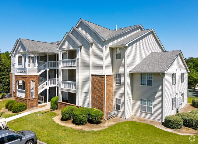
200 Charter Ln, Macon, GA 31210

Property Detail
200 Charter Ln
M062-0164
Bibb
Countryclub
Georgia
PDE
338&339
B and X Area of moderate flood hazard, usually the area between the limits of the 100-year and 500-year floods.
14.46 AC
2025
Bibb County
2025
Atlanta
012102
Macon-Bibb County, GA
2,366 SF
NEARBY LISTINGS FOR SALE OR LEASE
DEMOGRAPHICS near 200 Charter Ln
1 mile
3 mile
5 mile
2025 Total Population
5,183
36,523
93,981
2030 Population
5,117
36,211
94,289
Pop Growth 2025-2030
(1.27%)
(0.85%)
+ 0.33%
Average Age
39
39
39
2025 Total Households
2,222
15,491
39,283
HH Growth 2025-2030
(1.26%)
(0.90%)
+ 0.38%
Median Household Inc
$90,624
$68,893
$53,613
Avg Household Size
2.30
2.30
2.30
2025 Avg HH Vehicles
2.00
2.00
2.00
Median Home Value
$290,768
$233,415
$217,745
Median Year Built
1978
1973
1976
Nearby Places
Map Layers
Map Styles
 Street
 Aerial
Layers
 Traffic
 Biking
Places
Listings with unknown addresses are not visible on the map
- Restaurants
- Banks
- Shops
- Fitness
- Groceries
Nearby Properties
Address
Land Use
TOTAL SIZE
Lot Size
Zoning
Address
Land Use
TOTAL SIZE
Lot Size
Zoning
Address
Land Use
TOTAL SIZE
Lot Size
Zoning
196,702 SF
37.72 AC
PDE
Address
Land Use
TOTAL SIZE
Lot Size
Zoning
4,671 SF
22.66 AC
R-3
Address
Land Use
TOTAL SIZE
Lot Size
Zoning
194,734 SF
6.37 AC
C-2
Address
Land Use
TOTAL SIZE
Lot Size
Zoning
71,021 SF
8.94 AC
PDC
Address
Land Use
TOTAL SIZE
Lot Size
Zoning
231,774 SF
21.27 AC
R-1AAA
Address
Land Use
TOTAL SIZE
Lot Size
Zoning
51,786 SF
21.05 AC
PDR
Address
Land Use
TOTAL SIZE
Lot Size
Zoning
1,039 SF
14.79 AC
PDR
Address
Land Use
TOTAL SIZE
Lot Size
Zoning
1,452 SF
12.16 AC
R-3
Address
Land Use
TOTAL SIZE
Lot Size
Zoning
6,720 SF
16.69 AC
PDR
Address
Land Use
TOTAL SIZE
Lot Size
Zoning
4,030 SF
11.99 AC
A
Address
Land Use
TOTAL SIZE
Lot Size
Zoning
85,556 SF
10.50 AC
R-1A
Address
Land Use
TOTAL SIZE
Lot Size
Zoning
110,745 SF
4.99 AC
PDE
Address
Land Use
TOTAL SIZE
Lot Size
Zoning
63,654 SF
14.67 AC
C-2
Address
Land Use
TOTAL SIZE
Lot Size
Zoning
23,520 SF
12.78 AC
R-3
Address
Land Use
TOTAL SIZE
Lot Size
Zoning
3,600 SF
24.71 AC
R-1AAA
Address
Land Use
TOTAL SIZE
Lot Size
Zoning
20,518 SF
19.58 AC
R-3
Address
Land Use
TOTAL SIZE
Lot Size
Zoning
2,816 SF
12.46 AC
R-2
Address
Land Use
TOTAL SIZE
Lot Size
Zoning
16,320 SF
8.60 AC
R-3
Address
Land Use
TOTAL SIZE
Lot Size
Zoning
48,524 SF
1.80 AC
C-2
Address
Land Use
TOTAL SIZE
Lot Size
Zoning
50,918 SF
2 AC
C-2
Address
Land Use
TOTAL SIZE
Lot Size
Zoning
117,083 SF
8.32 AC
PDR
Address
Land Use
TOTAL SIZE
Lot Size
Zoning
20,572 SF
16.08 AC
R-3
Address
Land Use
TOTAL SIZE
Lot Size
Zoning
16,180 SF
9.52 AC
C-1
Address
Land Use
TOTAL SIZE
Lot Size
Zoning
76,578 SF
13.60 AC
R-1AAA
Address
Land Use
TOTAL SIZE
Lot Size
Zoning
47,952 SF
2.14 AC
C-2
Address
Land Use
TOTAL SIZE
Lot Size
Zoning
13,344 SF
10.83 AC
R-3
Address
Land Use
TOTAL SIZE
Lot Size
Zoning
44,720 SF
6.33 AC
C-2
Address
Land Use
TOTAL SIZE
Lot Size
Zoning
1,885 SF
12.62 AC
R-3
The World's #1 Commercial Real Estate Marketplace
Connect with us
© 2026 CoStar Group
The information above has been obtained from sources believed reliable. While we do not doubt its accuracy we have not verified it and make no guarantee, warranty or representation about it. It is your responsibility to independently confirm its accuracy and completeness. Any projections, opinions, assumptions, or estimates used are for example only and do not represent the current or future performance of the property. The value of this transaction to you depends on tax and other factors which should be evaluated by your tax, financial, and legal advisors. You and your advisors should conduct a careful, independent investigation of the property to determine to your satisfaction the suitability of the property for your needs.