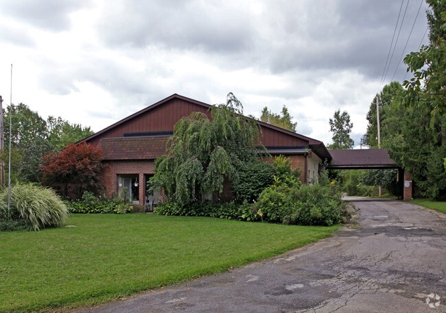
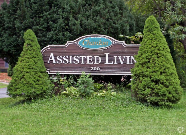
Property Record
200 Claridon Rd, Chardon, OH 44024

Property Detail
200 Claridon Rd
Cleveland-Elyria, OH
LOT 145
10-709630
Geauga
Commercialnec
Ohio
2025
145
2025
1 AC
312201
Geauga County
5,288 SF
Cleveland
NEARBY LISTINGS FOR SALE OR LEASE
DEMOGRAPHICS near 200 Claridon Rd
1 mile
3 mile
5 mile
2025 Total Population
4,150
12,779
22,366
2030 Population
4,151
12,840
22,419
Pop Growth 2025-2030
+ 0.02%
+ 0.48%
+ 0.24%
Average Age
44
44
44
2025 Total Households
1,828
5,274
8,814
HH Growth 2025-2030
(0.05%)
+ 0.47%
+ 0.24%
Median Household Inc
$93,277
$86,086
$99,628
Avg Household Size
2.20
2.30
2.40
2025 Avg HH Vehicles
2.00
2.00
2.00
Median Home Value
$295,768
$283,641
$311,152
Median Year Built
1979
1979
1980
Nearby Places
Map Layers
Map Styles
 Street
 Aerial
Layers
 Traffic
 Biking
Places
Listings with unknown addresses are not visible on the map
- Restaurants
- Banks
- Shops
- Fitness
- Groceries
PUBLIC TRANSPORTATION
AIRPORT
Cleveland-Hopkins International
Drive
Walk
Distance
Cleveland-Hopkins International
68 min
43.8 mi
Nearby Properties
Address
Land Use
TOTAL SIZE
Lot Size
Zoning
Address
Land Use
TOTAL SIZE
Lot Size
Zoning
8,618 SF
19.46 AC
Address
Land Use
TOTAL SIZE
Lot Size
Zoning
188,150 SF
20.01 AC
C3
Address
Land Use
TOTAL SIZE
Lot Size
Zoning
70,289 SF
12.03 AC
PUD
Address
Land Use
TOTAL SIZE
Lot Size
Zoning
98,228 SF
20 AC
S
Address
Land Use
TOTAL SIZE
Lot Size
Zoning
123,170 SF
7.50 AC
S
Address
Land Use
TOTAL SIZE
Lot Size
Zoning
140,974 SF
15.62 AC
IWTTO
Address
Land Use
TOTAL SIZE
Lot Size
Zoning
50,048 SF
14.78 AC
C3
Address
Land Use
TOTAL SIZE
Lot Size
Zoning
960 SF
552.62 AC
Address
Land Use
TOTAL SIZE
Lot Size
Zoning
5,847 SF
14.15 AC
R2
Address
Land Use
TOTAL SIZE
Lot Size
Zoning
105,182 SF
10.64 AC
IWTTO
Address
Land Use
TOTAL SIZE
Lot Size
Zoning
1,870 SF
102.70 AC
R1
Address
Land Use
TOTAL SIZE
Lot Size
Zoning
106,658 SF
14.40 AC
C3
Address
Land Use
TOTAL SIZE
Lot Size
Zoning
36,696 SF
10.30 AC
R3
Address
Land Use
TOTAL SIZE
Lot Size
Zoning
80,188 SF
5.83 AC
C3
Address
Land Use
TOTAL SIZE
Lot Size
Zoning
2,370 SF
43.96 AC
MHP
Address
Land Use
TOTAL SIZE
Lot Size
Zoning
3,024 SF
66.06 AC
Address
Land Use
TOTAL SIZE
Lot Size
Zoning
15,293 SF
19.32 AC
Address
Land Use
TOTAL SIZE
Lot Size
Zoning
35,159 SF
0.42 AC
R2
Address
Land Use
TOTAL SIZE
Lot Size
Zoning
55,768 SF
9.84 AC
C3
Address
Land Use
TOTAL SIZE
Lot Size
Zoning
6,840 SF
12.42 AC
R1
Address
Land Use
TOTAL SIZE
Lot Size
Zoning
29,878 SF
5.77 AC
C3
Address
Land Use
TOTAL SIZE
Lot Size
Zoning
38,367 SF
5.29 AC
C3
Address
Land Use
TOTAL SIZE
Lot Size
Zoning
66,551 SF
13.25 AC
PUD
Address
Land Use
TOTAL SIZE
Lot Size
Zoning
67,501 SF
6.59 AC
C3
Address
Land Use
TOTAL SIZE
Lot Size
Zoning
25,898 SF
2.26 AC
R2
Address
Land Use
TOTAL SIZE
Lot Size
Zoning
12,800 SF
7.50 AC
R4
Address
Land Use
TOTAL SIZE
Lot Size
Zoning
3,480 SF
9.30 AC
PUD
Address
Land Use
TOTAL SIZE
Lot Size
Zoning
68,539 SF
7.06 AC
IWTTO
Address
Land Use
TOTAL SIZE
Lot Size
Zoning
240 SF
188.67 AC
Address
Land Use
TOTAL SIZE
Lot Size
Zoning
19,001 SF
8.75 AC
R2
The World's #1 Commercial Real Estate Marketplace
Connect with us
© 2026 CoStar Group
The information above has been obtained from sources believed reliable. While we do not doubt its accuracy we have not verified it and make no guarantee, warranty or representation about it. It is your responsibility to independently confirm its accuracy and completeness. Any projections, opinions, assumptions, or estimates used are for example only and do not represent the current or future performance of the property. The value of this transaction to you depends on tax and other factors which should be evaluated by your tax, financial, and legal advisors. You and your advisors should conduct a careful, independent investigation of the property to determine to your satisfaction the suitability of the property for your needs.