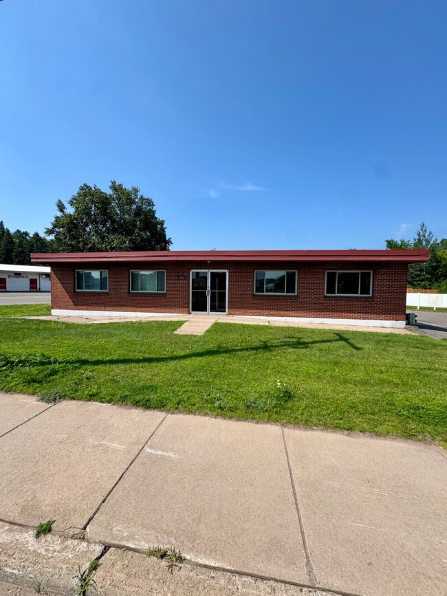
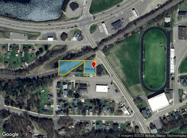
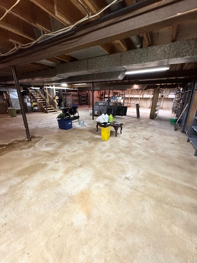
Property Record
200 Cliff St, Negaunee, MI 49866
This Property Is For Sale
NEARBY LISTINGS FOR SALE OR LEASE
Property Detail
200 Cliff St
Marquette, MI
Pioneer Iron Cos 2Nd Add
52-53-030-002-00
Marquette
Sfr
Michigan
X
0.73 AC
26103C0465E
Upper Peninsula
2,576 SF
Other Market Areas
DEMOGRAPHICS near 200 Cliff St
1 Mile
3 Mile
5 Mile
2024 Total Population
3,815
9,468
15,184
2029 Population
3,824
9,480
15,227
Pop Growth 2024-2029
+ 0.24%
+ 0.13%
+ 0.28%
Average Age
40
40
41
2024 Total Households
1,602
4,043
6,372
HH Growth 2024-2029
+ 0.44%
+ 0.35%
+ 0.52%
Median Household Inc
$66,153
$61,222
$63,013
Avg Household Size
2.30
2.20
2.30
2024 Avg HH Vehicles
2.00
2.00
2.00
Median Home Value
$170,537
$159,788
$167,297
Median Year Built
1949
1949
1953
Nearby Places
- Restaurants
- Banks
- Shops
- Fitness
- Groceries
PUBLIC TRANSPORTATION
AIRPORT
Marquette/Sawyer Regional
DRIVE
WALK
Distance
Marquette/Sawyer Regional
33 min
19.2 mi
Freight Ports
Port Milwaukee
DRIVE
WALK
Distance
Port Milwaukee
347 min
284.4 mi
Nearby Properties
Address
Land Use
TOTAL SIZE
Lot Size
Zoning
Address
Land Use
TOTAL SIZE
Lot Size
Zoning
58,319 SF
19.77 AC
B-2
Address
Land Use
TOTAL SIZE
Lot Size
Zoning
45,821 SF
3.02 AC
B-2
Address
Land Use
TOTAL SIZE
Lot Size
Zoning
41,480 SF
3.79 AC
B-2
Address
Land Use
TOTAL SIZE
Lot Size
Zoning
31,930 SF
6.44 AC
R-2
Address
Land Use
TOTAL SIZE
Lot Size
Zoning
32,858 SF
6.19 AC
B-2
Address
Land Use
TOTAL SIZE
Lot Size
Zoning
6,724 SF
1.29 AC
GC
Address
Land Use
TOTAL SIZE
Lot Size
Zoning
41,160 SF
13.22 AC
B-2
Address
Land Use
TOTAL SIZE
Lot Size
Zoning
16,800 SF
10.30 AC
I - IND
Address
Land Use
TOTAL SIZE
Lot Size
Zoning
31,075 SF
1 AC
GC
Address
Land Use
TOTAL SIZE
Lot Size
Zoning
24,124 SF
1.89 AC
B-2
Address
Land Use
TOTAL SIZE
Lot Size
Zoning
10,559 SF
0.84 AC
B-2
Address
Land Use
TOTAL SIZE
Lot Size
Zoning
4,814 SF
1.50 AC
B-2
Address
Land Use
TOTAL SIZE
Lot Size
Zoning
23,868 SF
32.62 AC
R-2-SFR
Address
Land Use
TOTAL SIZE
Lot Size
Zoning
28,280 SF
3.26 AC
MR
Address
Land Use
TOTAL SIZE
Lot Size
Zoning
12,755 SF
4.32 AC
GB GENERAL
Address
Land Use
TOTAL SIZE
Lot Size
Zoning
19,212 SF
2.06 AC
B-1-BUS
Address
Land Use
TOTAL SIZE
Lot Size
Zoning
28,060 SF
16.65 AC
GB GENERAL
Address
Land Use
TOTAL SIZE
Lot Size
Zoning
6,676 SF
0.37 AC
Address
Land Use
TOTAL SIZE
Lot Size
Zoning
3,900 SF
1.37 AC
B-2
Address
Land Use
TOTAL SIZE
Lot Size
Zoning
9,360 SF
0.84 AC
B-2
Address
Land Use
TOTAL SIZE
Lot Size
Zoning
10,448 SF
1.64 AC
B-1-BUS
Address
Land Use
TOTAL SIZE
Lot Size
Zoning
11,550 SF
5.62 AC
B-1-BUS
Address
Land Use
TOTAL SIZE
Lot Size
Zoning
16,300 SF
7.59 AC
B-2
Address
Land Use
TOTAL SIZE
Lot Size
Zoning
9,332 SF
0.23 AC
B-1
Address
Land Use
TOTAL SIZE
Lot Size
Zoning
10,450 SF
0.75 AC
B-2
Address
Land Use
TOTAL SIZE
Lot Size
Zoning
8,272 SF
0.11 AC
CBD
Address
Land Use
TOTAL SIZE
Lot Size
Zoning
16,916 SF
GC
Address
Land Use
TOTAL SIZE
Lot Size
Zoning
3,920 SF
0.70 AC
GC
Address
Land Use
TOTAL SIZE
Lot Size
Zoning
3,920 SF
0.44 AC
GC
Address
Land Use
TOTAL SIZE
Lot Size
Zoning
3,920 SF
1.06 AC
B-2
The World's #1 Commercial Real Estate Marketplace
Connect with us
© 2025 CoStar Group
The information above has been obtained from sources believed reliable. While we do not doubt its accuracy we have not verified it and make no guarantee, warranty or representation about it. It is your responsibility to independently confirm its accuracy and completeness. Any projections, opinions, assumptions, or estimates used are for example only and do not represent the current or future performance of the property. The value of this transaction to you depends on tax and other factors which should be evaluated by your tax, financial, and legal advisors. You and your advisors should conduct a careful, independent investigation of the property to determine to your satisfaction the suitability of the property for your needs.