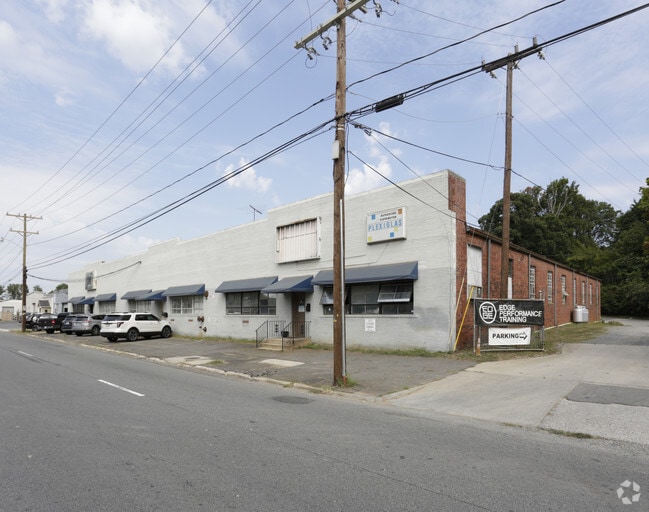
Property Record
200 Dalton Ave, Charlotte, NC 28206


Current Lease Availabilities
NEARBY LISTINGS FOR SALE OR LEASE
Property Detail
200 Dalton Ave
Charlotte-Concord-Gastonia, NC-SC
Lockewood
079-017-40
200 DALTON AVE
Industrialgeneral
Mecklenburg
X
North Carolina
3710455400K
40
2024
1.06 AC
2025
I-277/30th St
005200
Charlotte
25,148 SF
DEMOGRAPHICS near 200 Dalton Ave
1 mile
3 mile
5 mile
2024 Total Population
17,303
120,515
288,198
2029 Population
18,954
129,409
307,380
Pop Growth 2024-2029
+ 9.54%
+ 7.38%
+ 6.66%
Average Age
37
36
36
2024 Total Households
9,044
61,007
127,884
HH Growth 2024-2029
+ 9.93%
+ 7.55%
+ 6.82%
Median Household Inc
$65,388
$74,070
$62,910
Avg Household Size
1.80
1.90
2.20
2024 Avg HH Vehicles
1.00
1.00
2.00
Median Home Value
$366,399
$424,032
$344,971
Median Year Built
2002
2001
1987
Nearby Places
Map Layers
Map Styles
 Street
 Aerial
Transit
 Traffic
 Biking
Places
Listings with unknown addresses are not visible on the map
- Restaurants
- Banks
- Shops
- Fitness
- Groceries
PUBLIC TRANSPORTATION
COMMUTER RAIL
Drive
Walk
Distance
1 min
9 min
0.5 mi
AIRPORT
Charlotte/Douglas International
Drive
Walk
Distance
Charlotte/Douglas International
18 min
8.7 mi
Concord-Padgett Regional
Drive
Walk
Distance
Concord-Padgett Regional
23 min
14.1 mi
Nearby Properties
Address
Land Use
TOTAL SIZE
Lot Size
Zoning
Address
Land Use
TOTAL SIZE
Lot Size
Zoning
3,286,640 SF
55.70 AC
O6CD
Address
Land Use
TOTAL SIZE
Lot Size
Zoning
1,652,470 SF
10.96 AC
UMUD
Address
Land Use
TOTAL SIZE
Lot Size
Zoning
780,000 SF
7.69 AC
UMUD-O
Address
Land Use
TOTAL SIZE
Lot Size
Zoning
1,097,257 SF
2.34 AC
UMUD-O
Address
Land Use
TOTAL SIZE
Lot Size
Zoning
1,498,190 SF
2.09 AC
UMUD
Address
Land Use
TOTAL SIZE
Lot Size
Zoning
955,273 SF
1.83 AC
Address
Land Use
TOTAL SIZE
Lot Size
Zoning
1,483,634 SF
1.49 AC
Address
Land Use
TOTAL SIZE
Lot Size
Zoning
1,250,218 SF
17.75 AC
O2
Address
Land Use
TOTAL SIZE
Lot Size
Zoning
1,097,857 SF
2.40 AC
UMUDO
Address
Land Use
TOTAL SIZE
Lot Size
Zoning
1,052,203 SF
2.17 AC
Address
Land Use
TOTAL SIZE
Lot Size
Zoning
1,752,744 SF
3.20 AC
UMUDO
Address
Land Use
TOTAL SIZE
Lot Size
Zoning
1,266,700 SF
2.98 AC
Address
Land Use
TOTAL SIZE
Lot Size
Zoning
852,355 SF
16.72 AC
MUDDO
Address
Land Use
TOTAL SIZE
Lot Size
Zoning
1,325,933 SF
34.09 AC
Address
Land Use
TOTAL SIZE
Lot Size
Zoning
925,808 SF
1.84 AC
UMUD-O
Address
Land Use
TOTAL SIZE
Lot Size
Zoning
1,435,616 SF
33.78 AC
UMUD
Address
Land Use
TOTAL SIZE
Lot Size
Zoning
1,250,926 SF
4.89 AC
I2
Address
Land Use
TOTAL SIZE
Lot Size
Zoning
582,357 SF
1.13 AC
MUDD-O
Address
Land Use
TOTAL SIZE
Lot Size
Zoning
1,053,936 SF
2.47 AC
UMUD
Address
Land Use
TOTAL SIZE
Lot Size
Zoning
865,160 SF
2.80 AC
UMUD
Address
Land Use
TOTAL SIZE
Lot Size
Zoning
839,976 SF
1.62 AC
UMUD
Address
Land Use
TOTAL SIZE
Lot Size
Zoning
1,017,564 SF
13.91 AC
O2
Address
Land Use
TOTAL SIZE
Lot Size
Zoning
894,108 SF
4.52 AC
UMUDO
Address
Land Use
TOTAL SIZE
Lot Size
Zoning
696,527 SF
1.96 AC
UMUDO
Address
Land Use
TOTAL SIZE
Lot Size
Zoning
1,025,674 SF
3.43 AC
UMUD
Address
Land Use
TOTAL SIZE
Lot Size
Zoning
916,725 SF
2.35 AC
UMUD
Address
Land Use
TOTAL SIZE
Lot Size
Zoning
626,053 SF
2.77 AC
I2
Address
Land Use
TOTAL SIZE
Lot Size
Zoning
944,863 SF
3.58 AC
UMUD
Address
Land Use
TOTAL SIZE
Lot Size
Zoning
416,225 SF
0.64 AC
Address
Land Use
TOTAL SIZE
Lot Size
Zoning
1,039,198 SF
5.62 AC
UMUD
The World's #1 Commercial Real Estate Marketplace
Connect with us
© 2026 CoStar Group
The information above has been obtained from sources believed reliable. While we do not doubt its accuracy we have not verified it and make no guarantee, warranty or representation about it. It is your responsibility to independently confirm its accuracy and completeness. Any projections, opinions, assumptions, or estimates used are for example only and do not represent the current or future performance of the property. The value of this transaction to you depends on tax and other factors which should be evaluated by your tax, financial, and legal advisors. You and your advisors should conduct a careful, independent investigation of the property to determine to your satisfaction the suitability of the property for your needs.