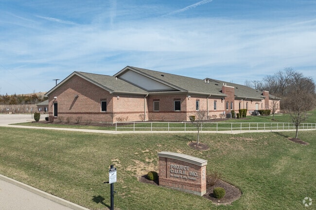
Property Record
200 Daruma Pky, Dayton, OH 45439

NEARBY LISTINGS FOR SALE OR LEASE
Property Detail
200 Daruma Pky
J44228226-0005
Moraine Commerce Park
Hospitalprivate
5449 MORAINE COMMERCE PARK SEC 3 EXEMPT
X
Montgomery
39113C0234E
Ohio
2023
6.26 AC
2024
South Central Dayton
060100
Cincinnati/Dayton
24,282 SF
Dayton, OH
DEMOGRAPHICS near 200 Daruma Pky
1 Mile
3 Mile
5 Mile
2024 Total Population
1,792
30,976
128,536
2029 Population
1,895
31,367
129,403
Pop Growth 2024-2029
+ 5.75%
+ 1.26%
+ 0.67%
Average Age
37
39
39
2024 Total Households
589
12,529
53,494
HH Growth 2024-2029
+ 6.28%
+ 1.20%
+ 0.70%
Median Household Inc
$71,062
$40,829
$49,130
Avg Household Size
2.70
2.30
2.20
2024 Avg HH Vehicles
2.00
2.00
2.00
Median Home Value
$148,125
$100,130
$146,545
Median Year Built
1986
1959
1959
Nearby Places
Map Layers
Map Styles
 Street
 Aerial
- Restaurants
- Banks
- Shops
- Fitness
- Groceries
PUBLIC TRANSPORTATION
AIRPORT
James M Cox Dayton International
DRIVE
WALK
Distance
James M Cox Dayton International
29 min
18.9 mi
Freight Ports
Port of Toledo
DRIVE
WALK
Distance
Port of Toledo
186 min
159.1 mi
SALE & LEASE HISTORY
LISTING DATE
SALE/LEASE

Feb 14, 2024
For Sale
Nearby Properties
Address
Land Use
TOTAL SIZE
Lot Size
Zoning
Address
Land Use
TOTAL SIZE
Lot Size
Zoning
134,515 SF
370.05 AC
Address
Land Use
TOTAL SIZE
Lot Size
Zoning
104,240 SF
36.80 AC
Address
Land Use
TOTAL SIZE
Lot Size
Zoning
125,433 SF
92.08 AC
Address
Land Use
TOTAL SIZE
Lot Size
Zoning
17,478 SF
417.01 AC
Address
Land Use
TOTAL SIZE
Lot Size
Zoning
6,204 SF
19.27 AC
Address
Land Use
TOTAL SIZE
Lot Size
Zoning
94.06 AC
Address
Land Use
TOTAL SIZE
Lot Size
Zoning
66.56 AC
Address
Land Use
TOTAL SIZE
Lot Size
Zoning
54.85 AC
Address
Land Use
TOTAL SIZE
Lot Size
Zoning
414,124 SF
14.98 AC
Address
Land Use
TOTAL SIZE
Lot Size
Zoning
330,404 SF
68.13 AC
Address
Land Use
TOTAL SIZE
Lot Size
Zoning
118,234 SF
25.72 AC
Address
Land Use
TOTAL SIZE
Lot Size
Zoning
600,884 SF
38.61 AC
Address
Land Use
TOTAL SIZE
Lot Size
Zoning
8.82 AC
Address
Land Use
TOTAL SIZE
Lot Size
Zoning
439,169 SF
16 AC
Address
Land Use
TOTAL SIZE
Lot Size
Zoning
121,875 SF
8.21 AC
Address
Land Use
TOTAL SIZE
Lot Size
Zoning
46,088 SF
29.95 AC
Address
Land Use
TOTAL SIZE
Lot Size
Zoning
25.32 AC
Address
Land Use
TOTAL SIZE
Lot Size
Zoning
209,991 SF
11.77 AC
Address
Land Use
TOTAL SIZE
Lot Size
Zoning
439,169 SF
16 AC
Address
Land Use
TOTAL SIZE
Lot Size
Zoning
414,124 SF
14.98 AC
Address
Land Use
TOTAL SIZE
Lot Size
Zoning
18.23 AC
Address
Land Use
TOTAL SIZE
Lot Size
Zoning
66,126 SF
31.79 AC
Address
Land Use
TOTAL SIZE
Lot Size
Zoning
312,169 SF
17.86 AC
Address
Land Use
TOTAL SIZE
Lot Size
Zoning
204,800 SF
14.48 AC
Address
Land Use
TOTAL SIZE
Lot Size
Zoning
74,880 SF
3.56 AC
Address
Land Use
TOTAL SIZE
Lot Size
Zoning
150,033 SF
6.64 AC
Address
Land Use
TOTAL SIZE
Lot Size
Zoning
293,880 SF
29.96 AC
Address
Land Use
TOTAL SIZE
Lot Size
Zoning
64,000 SF
5.74 AC
Address
Land Use
TOTAL SIZE
Lot Size
Zoning
50,310 SF
9.24 AC
Address
Land Use
TOTAL SIZE
Lot Size
Zoning
109,720 SF
6.98 AC
The World's #1 Commercial Real Estate Marketplace
Connect with us
© 2025 CoStar Group
The information above has been obtained from sources believed reliable. While we do not doubt its accuracy we have not verified it and make no guarantee, warranty or representation about it. It is your responsibility to independently confirm its accuracy and completeness. Any projections, opinions, assumptions, or estimates used are for example only and do not represent the current or future performance of the property. The value of this transaction to you depends on tax and other factors which should be evaluated by your tax, financial, and legal advisors. You and your advisors should conduct a careful, independent investigation of the property to determine to your satisfaction the suitability of the property for your needs.