Property Record
200 Dunlap Dr, Mobile, AL 36602

Property Detail
200 Dunlap Dr
Mobile, AL
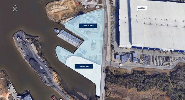
Blakeley Island
29-05-00-0-006-004
COMMENCING AT THE POINT OF INTERSECTION OF THE NORTH LINE OF LOT 1 AUSTAL OUTFIT YARD 1 MBK 125 PAGE 119 AND THE WEST LINE OF
Officebuilding
Mobile
AE
Alabama
01097C0558L
1
2025
7.95 AC
2025
Northeast Mobile
001200
Mobile
600 SF
NEARBY LISTINGS FOR SALE OR LEASE
DEMOGRAPHICS near 200 Dunlap Dr
1 mile
3 mile
5 mile
2024 Total Population
1,676
24,115
70,111
2029 Population
1,708
24,573
71,224
Pop Growth 2024-2029
+ 1.91%
+ 1.90%
+ 1.59%
Average Age
45
41
41
2024 Total Households
681
10,494
29,560
HH Growth 2024-2029
+ 2.50%
+ 1.83%
+ 1.56%
Median Household Inc
$38,076
$35,523
$38,022
Avg Household Size
1.70
2.10
2.20
2024 Avg HH Vehicles
1.00
1.00
2.00
Median Home Value
$96,666
$141,483
$96,071
Median Year Built
1972
1958
1959
Nearby Places
Map Layers
Map Styles
 Street
 Aerial
Transit
 Traffic
 Biking
Places
Listings with unknown addresses are not visible on the map
- Restaurants
- Banks
- Shops
- Fitness
- Groceries
PUBLIC TRANSPORTATION
AIRPORT
Mobile International
Drive
Walk
Distance
Mobile International
12 min
6.6 mi
Mobile Regional
Drive
Walk
Distance
Mobile Regional
34 min
15.7 mi
Freight Ports
Port of Mobile
Drive
Walk
Distance
Port of Mobile
6 min
2.3 mi
SALE & LEASE HISTORY
LISTING DATE
SALE/LEASE

Aug 24, 2022
For Sale
Nearby Properties
Address
Land Use
TOTAL SIZE
Lot Size
Zoning
Address
Land Use
TOTAL SIZE
Lot Size
Zoning
62,699 SF
2.47 AC
Address
Land Use
TOTAL SIZE
Lot Size
Zoning
410,802 SF
109.06 AC
Address
Land Use
TOTAL SIZE
Lot Size
Zoning
368,115 SF
86.30 AC
Address
Land Use
TOTAL SIZE
Lot Size
Zoning
171,670 SF
20.19 AC
Address
Land Use
TOTAL SIZE
Lot Size
Zoning
8,000 SF
0.90 AC
Address
Land Use
TOTAL SIZE
Lot Size
Zoning
22,980 SF
24.46 AC
Address
Land Use
TOTAL SIZE
Lot Size
Zoning
109,359 SF
1.67 AC
Address
Land Use
TOTAL SIZE
Lot Size
Zoning
339,141 SF
7.18 AC
Address
Land Use
TOTAL SIZE
Lot Size
Zoning
224,336 SF
2.43 AC
Address
Land Use
TOTAL SIZE
Lot Size
Zoning
106,800 SF
8 AC
Address
Land Use
TOTAL SIZE
Lot Size
Zoning
318,096 SF
6.80 AC
Address
Land Use
TOTAL SIZE
Lot Size
Zoning
288,486 SF
16.32 AC
Address
Land Use
TOTAL SIZE
Lot Size
Zoning
128,384 SF
106.56 AC
Address
Land Use
TOTAL SIZE
Lot Size
Zoning
32,556 SF
11.38 AC
Address
Land Use
TOTAL SIZE
Lot Size
Zoning
24,437 SF
32.74 AC
Address
Land Use
TOTAL SIZE
Lot Size
Zoning
137,712 SF
61.95 AC
Address
Land Use
TOTAL SIZE
Lot Size
Zoning
131,906 SF
4.62 AC
Address
Land Use
TOTAL SIZE
Lot Size
Zoning
104,160 SF
2.20 AC
Address
Land Use
TOTAL SIZE
Lot Size
Zoning
272,912 SF
3.32 AC
Address
Land Use
TOTAL SIZE
Lot Size
Zoning
31.14 AC
Address
Land Use
TOTAL SIZE
Lot Size
Zoning
70,366 SF
3.75 AC
Address
Land Use
TOTAL SIZE
Lot Size
Zoning
58,192 SF
1.81 AC
Address
Land Use
TOTAL SIZE
Lot Size
Zoning
5,411 SF
58.27 AC
Address
Land Use
TOTAL SIZE
Lot Size
Zoning
126,847 SF
86.30 AC
Address
Land Use
TOTAL SIZE
Lot Size
Zoning
334,636 SF
38 AC
Address
Land Use
TOTAL SIZE
Lot Size
Zoning
4,320 SF
26.79 AC
Address
Land Use
TOTAL SIZE
Lot Size
Zoning
90,040 SF
64.03 AC
Address
Land Use
TOTAL SIZE
Lot Size
Zoning
50,400 SF
57.20 AC
Address
Land Use
TOTAL SIZE
Lot Size
Zoning
46,557 SF
14.66 AC
Address
Land Use
TOTAL SIZE
Lot Size
Zoning
1,000 SF
33.20 AC
The World's #1 Commercial Real Estate Marketplace
Connect with us
© 2026 CoStar Group
The information above has been obtained from sources believed reliable. While we do not doubt its accuracy we have not verified it and make no guarantee, warranty or representation about it. It is your responsibility to independently confirm its accuracy and completeness. Any projections, opinions, assumptions, or estimates used are for example only and do not represent the current or future performance of the property. The value of this transaction to you depends on tax and other factors which should be evaluated by your tax, financial, and legal advisors. You and your advisors should conduct a careful, independent investigation of the property to determine to your satisfaction the suitability of the property for your needs.