Property Record
200 E 200 E E, Chesterton, IN 46304
Property Detail
200 E 200 E E
Chicago-Naperville-Elgin, IL-IN
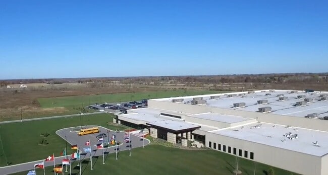
RD ROW ENTRANCE TO PRIVATE RD CUTTING EDGE DR W SIDE LOT1 PH1 URSHEL LAB HDQTR & MANUF CAMPUS 1.053A
64-07-07-477-001.000-007
PORTER
Industrialacreage
Indiana
A Areas with a 1% annual chance of flooding and a 26% chance of flooding over the life of a 30-year mortgage.
1
2024
85.62 AC
2025
Porter County
050202
Chicago
NEARBY LISTINGS FOR SALE OR LEASE
DEMOGRAPHICS near 200 E 200 E E
1 mile
3 mile
5 mile
2024 Total Population
2,316
17,078
40,390
2029 Population
2,401
17,339
40,869
Pop Growth 2024-2029
+ 3.67%
+ 1.53%
+ 1.19%
Average Age
44
43
42
2024 Total Households
874
6,631
15,660
HH Growth 2024-2029
+ 3.66%
+ 1.39%
+ 1.05%
Median Household Inc
$134,062
$90,504
$81,016
Avg Household Size
2.60
2.50
2.50
2024 Avg HH Vehicles
2.00
2.00
2.00
Median Home Value
$375,666
$329,293
$317,241
Median Year Built
2002
1987
1984
Nearby Places
Map Layers
Map Styles
 Street
 Aerial
Transit
 Traffic
 Biking
Places
Listings with unknown addresses are not visible on the map
- Restaurants
- Banks
- Shops
- Fitness
- Groceries
PUBLIC TRANSPORTATION
COMMUTER RAIL
Dune Park (Chesterton) Station (South Shore Line - Northern Indiana Commuter Transportation District (South Shore Line))
Drive
Walk
Distance
Dune Park (Chesterton) Station (South Shore Line - Northern Indiana Commuter Transportation District (South Shore Line))
10 min
5.4 mi
Beverly Shores (South Shore Line - Northern Indiana Commuter Transportation District (South Shore Line))
Drive
Walk
Distance
Beverly Shores (South Shore Line - Northern Indiana Commuter Transportation District (South Shore Line))
17 min
9.1 mi
Freight Ports
Port Milwaukee
Drive
Walk
Distance
Port Milwaukee
168 min
133.1 mi
Nearby Properties
Address
Land Use
TOTAL SIZE
Lot Size
Zoning
Address
Land Use
TOTAL SIZE
Lot Size
Zoning
389,754 SF
65.32 AC
Address
Land Use
TOTAL SIZE
Lot Size
Zoning
531,461 SF
36.43 AC
Address
Land Use
TOTAL SIZE
Lot Size
Zoning
159,404 SF
15.84 AC
Address
Land Use
TOTAL SIZE
Lot Size
Zoning
174,766 SF
17.47 AC
Address
Land Use
TOTAL SIZE
Lot Size
Zoning
109,131 SF
7.38 AC
Address
Land Use
TOTAL SIZE
Lot Size
Zoning
78,087 SF
8.51 AC
Address
Land Use
TOTAL SIZE
Lot Size
Zoning
108,528 SF
10.28 AC
Address
Land Use
TOTAL SIZE
Lot Size
Zoning
72,408 SF
2.75 AC
Address
Land Use
TOTAL SIZE
Lot Size
Zoning
88,064 SF
3.87 AC
Address
Land Use
TOTAL SIZE
Lot Size
Zoning
61,248 SF
6.77 AC
Address
Land Use
TOTAL SIZE
Lot Size
Zoning
52,765 SF
5.92 AC
Address
Land Use
TOTAL SIZE
Lot Size
Zoning
61,873 SF
8 AC
Address
Land Use
TOTAL SIZE
Lot Size
Zoning
50,191 SF
2.43 AC
Address
Land Use
TOTAL SIZE
Lot Size
Zoning
62,127 SF
64.25 AC
Address
Land Use
TOTAL SIZE
Lot Size
Zoning
114,061 SF
6.26 AC
Address
Land Use
TOTAL SIZE
Lot Size
Zoning
38,337 SF
10 AC
Address
Land Use
TOTAL SIZE
Lot Size
Zoning
35,456 SF
7.88 AC
Address
Land Use
TOTAL SIZE
Lot Size
Zoning
62,401 SF
9.83 AC
Address
Land Use
TOTAL SIZE
Lot Size
Zoning
33,300 SF
1.97 AC
Address
Land Use
TOTAL SIZE
Lot Size
Zoning
62,261 SF
5.69 AC
Address
Land Use
TOTAL SIZE
Lot Size
Zoning
9,512 SF
1.02 AC
Address
Land Use
TOTAL SIZE
Lot Size
Zoning
42.89 AC
Address
Land Use
TOTAL SIZE
Lot Size
Zoning
26,090 SF
5.68 AC
Address
Land Use
TOTAL SIZE
Lot Size
Zoning
116,800 SF
10.52 AC
Address
Land Use
TOTAL SIZE
Lot Size
Zoning
15,247 SF
1.55 AC
Address
Land Use
TOTAL SIZE
Lot Size
Zoning
62,068 SF
10.56 AC
Address
Land Use
TOTAL SIZE
Lot Size
Zoning
20,400 SF
7.39 AC
Address
Land Use
TOTAL SIZE
Lot Size
Zoning
11,978 SF
20 AC
Address
Land Use
TOTAL SIZE
Lot Size
Zoning
56,807 SF
9.10 AC
Address
Land Use
TOTAL SIZE
Lot Size
Zoning
15,788 SF
1.50 AC
The World's #1 Commercial Real Estate Marketplace
Connect with us
© 2026 CoStar Group
The information above has been obtained from sources believed reliable. While we do not doubt its accuracy we have not verified it and make no guarantee, warranty or representation about it. It is your responsibility to independently confirm its accuracy and completeness. Any projections, opinions, assumptions, or estimates used are for example only and do not represent the current or future performance of the property. The value of this transaction to you depends on tax and other factors which should be evaluated by your tax, financial, and legal advisors. You and your advisors should conduct a careful, independent investigation of the property to determine to your satisfaction the suitability of the property for your needs.