Property Record
200 E Arapaho Rd, Richardson, TX 75081

NEARBY LISTINGS FOR SALE OR LEASE
Property Detail
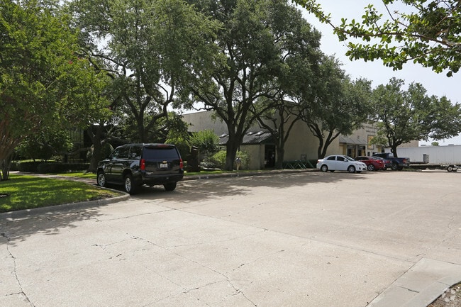
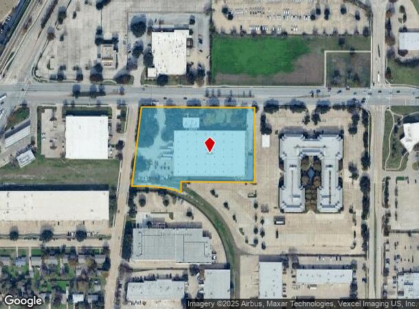
200 E Arapaho Rd
Dallas-Fort Worth-Arlington, TX
Richardson Ind Park 2Nd Inst
42196600000010000
RICHARDSON IND PARK 2ND INST LOT 1 & 1ST INST PT LOT 5 ACS 4.7386 INT201800334128 DD12192018 CO-DC 1966000000100 2CR19660000
Warehouse
Dallas
X
Texas
48085C0505K
1,5
2024
4.74 AC
2025
Richardson
019102
Dallas/Ft Worth
79,580 SF
DEMOGRAPHICS near 200 E Arapaho Rd
1 Mile
3 Mile
5 Mile
2024 Total Population
8,515
134,274
374,070
2029 Population
8,444
137,153
391,038
Pop Growth 2024-2029
(0.83%)
+ 2.14%
+ 4.54%
Average Age
38
37
38
2024 Total Households
3,523
50,236
147,179
HH Growth 2024-2029
(1.08%)
+ 2.71%
+ 5.25%
Median Household Inc
$67,261
$73,719
$67,308
Avg Household Size
2.30
2.50
2.40
2024 Avg HH Vehicles
2.00
2.00
2.00
Median Home Value
$263,938
$314,067
$336,198
Median Year Built
1968
1977
1980
Nearby Places
Map Layers
Map Styles
 Street
 Aerial
- Restaurants
- Banks
- Shops
- Fitness
- Groceries
PUBLIC TRANSPORTATION
AIRPORT
Dallas Love Field
DRIVE
WALK
Distance
Dallas Love Field
25 min
16.2 mi
Dallas-Fort Worth International
DRIVE
WALK
Distance
Dallas-Fort Worth International
32 min
25.1 mi
Nearby Properties
Address
Land Use
TOTAL SIZE
Lot Size
Zoning
Address
Land Use
TOTAL SIZE
Lot Size
Zoning
1,049,441 SF
Address
Land Use
TOTAL SIZE
Lot Size
Zoning
1,050,550 SF
18.24 AC
Address
Land Use
TOTAL SIZE
Lot Size
Zoning
7,706,477 SF
245.55 AC
Z116
Address
Land Use
TOTAL SIZE
Lot Size
Zoning
641,243 SF
20.67 AC
Z109
Address
Land Use
TOTAL SIZE
Lot Size
Zoning
1,105,509 SF
92.46 AC
A
Address
Land Use
TOTAL SIZE
Lot Size
Zoning
686,032 SF
9 AC
R2000
Address
Land Use
TOTAL SIZE
Lot Size
Zoning
369,694 SF
Address
Land Use
TOTAL SIZE
Lot Size
Zoning
445,071 SF
107.94 AC
2493-A TO-
Address
Land Use
TOTAL SIZE
Lot Size
Zoning
595,150 SF
17.20 AC
MF-H
Address
Land Use
TOTAL SIZE
Lot Size
Zoning
487,093 SF
6.28 AC
MF-E
Address
Land Use
TOTAL SIZE
Lot Size
Zoning
507,693 SF
32.50 AC
MFL
Address
Land Use
TOTAL SIZE
Lot Size
Zoning
393,416 SF
Address
Land Use
TOTAL SIZE
Lot Size
Zoning
706,061 SF
36.76 AC
Z109
Address
Land Use
TOTAL SIZE
Lot Size
Zoning
428,956 SF
18.76 AC
Z291
Address
Land Use
TOTAL SIZE
Lot Size
Zoning
509,566 SF
34.05 AC
PD
Address
Land Use
TOTAL SIZE
Lot Size
Zoning
386,448 SF
Address
Land Use
TOTAL SIZE
Lot Size
Zoning
324,000 SF
6.67 AC
O-S
Address
Land Use
TOTAL SIZE
Lot Size
Zoning
129,810 SF
14.93 AC
Z236
Address
Land Use
TOTAL SIZE
Lot Size
Zoning
795,714 SF
5.36 AC
Z109
Address
Land Use
TOTAL SIZE
Lot Size
Zoning
249,692 SF
244.62 AC
Z239
Address
Land Use
TOTAL SIZE
Lot Size
Zoning
355,408 SF
3.08 AC
LI-1
Address
Land Use
TOTAL SIZE
Lot Size
Zoning
402,815 SF
5.64 AC
Z236
Address
Land Use
TOTAL SIZE
Lot Size
Zoning
537,928 SF
11.13 AC
Z109
Address
Land Use
TOTAL SIZE
Lot Size
Zoning
426,467 SF
24.12 AC
Z142
Address
Land Use
TOTAL SIZE
Lot Size
Zoning
681,916 SF
4.80 AC
Z31
Address
Land Use
TOTAL SIZE
Lot Size
Zoning
1,464,834 SF
18.37 AC
Z109
Address
Land Use
TOTAL SIZE
Lot Size
Zoning
284,231 SF
3.95 AC
MF-E
Address
Land Use
TOTAL SIZE
Lot Size
Zoning
211,607 SF
Address
Land Use
TOTAL SIZE
Lot Size
Zoning
542,845 SF
3.90 AC
MF-R
The World's #1 Commercial Real Estate Marketplace
Connect with us
© 2025 CoStar Group
The information above has been obtained from sources believed reliable. While we do not doubt its accuracy we have not verified it and make no guarantee, warranty or representation about it. It is your responsibility to independently confirm its accuracy and completeness. Any projections, opinions, assumptions, or estimates used are for example only and do not represent the current or future performance of the property. The value of this transaction to you depends on tax and other factors which should be evaluated by your tax, financial, and legal advisors. You and your advisors should conduct a careful, independent investigation of the property to determine to your satisfaction the suitability of the property for your needs.