No Photo
Property Record
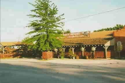
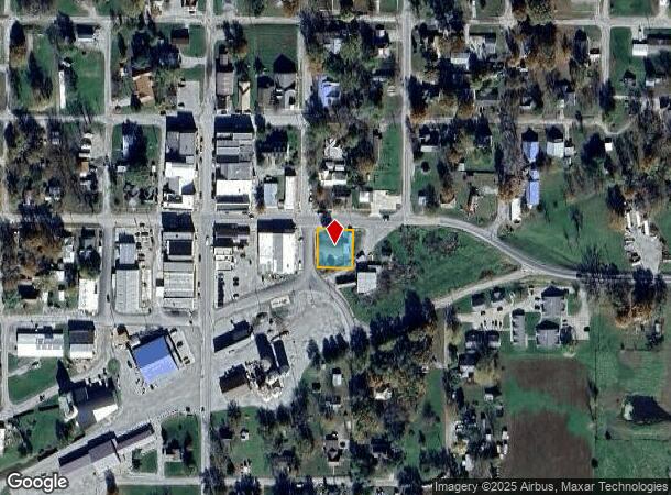
200 E Auberry Grv, Jamesport, MO 64648
NEARBY LISTINGS FOR SALE OR LEASE
-
-
View all Jamesport listings for sale on LoopNet.com
Property Detail
200 E Auberry Grv
09-8.1-27-4-06-19
ALL OF LOT 1 BLK 1 OF JAMESPORT, MO EXCEPT 10' OFF THE EAST SIDE THEREOF 105.5 X 95.5
Storebuilding
Daviess
X
Missouri
29061C0300B
1
2025
0.20 AC
2025
Missouri North Area
470200
Other Market Areas
2,880 SF
DEMOGRAPHICS near 200 E Auberry Grv
1 mile
3 mile
5 mile
2024 Total Population
657
1,012
1,480
2029 Population
653
1,004
1,463
Pop Growth 2024-2029
(0.61%)
(0.79%)
(1.15%)
Average Age
37
38
38
2024 Total Households
255
376
534
HH Growth 2024-2029
(0.39%)
(0.80%)
(1.31%)
Median Household Inc
$43,333
$52,647
$56,770
Avg Household Size
2.40
2.50
2.60
2024 Avg HH Vehicles
2.00
2.00
2.00
Median Home Value
$68,548
$81,594
$95,651
Median Year Built
1970
1971
1972
Nearby Places
Map Layers
Map Styles
 Street
 Aerial
Transit
 Traffic
 Biking
Places
Listings with unknown addresses are not visible on the map
- Restaurants
- Banks
- Shops
- Fitness
- Groceries
Nearby Properties
Address
Land Use
TOTAL SIZE
Lot Size
Zoning
Address
Land Use
TOTAL SIZE
Lot Size
Zoning
1,664 SF
4.30 AC
Address
Land Use
TOTAL SIZE
Lot Size
Zoning
1,865 SF
44.60 AC
Address
Land Use
TOTAL SIZE
Lot Size
Zoning
14,490 SF
3.30 AC
Address
Land Use
TOTAL SIZE
Lot Size
Zoning
12,765 SF
2 AC
Address
Land Use
TOTAL SIZE
Lot Size
Zoning
1,500 SF
15.70 AC
Address
Land Use
TOTAL SIZE
Lot Size
Zoning
1,040 SF
182.20 AC
Address
Land Use
TOTAL SIZE
Lot Size
Zoning
1,892 SF
77.70 AC
Address
Land Use
TOTAL SIZE
Lot Size
Zoning
2,736 SF
6 AC
Address
Land Use
TOTAL SIZE
Lot Size
Zoning
1,512 SF
100 AC
Address
Land Use
TOTAL SIZE
Lot Size
Zoning
2,548 SF
80 AC
Address
Land Use
TOTAL SIZE
Lot Size
Zoning
9,626 SF
1 AC
Address
Land Use
TOTAL SIZE
Lot Size
Zoning
5,000 SF
1.30 AC
Address
Land Use
TOTAL SIZE
Lot Size
Zoning
418 SF
4.60 AC
Address
Land Use
TOTAL SIZE
Lot Size
Zoning
10,321 SF
1.20 AC
Address
Land Use
TOTAL SIZE
Lot Size
Zoning
2,940 SF
46.40 AC
Address
Land Use
TOTAL SIZE
Lot Size
Zoning
7,675 SF
3.80 AC
Address
Land Use
TOTAL SIZE
Lot Size
Zoning
4,560 SF
201.50 AC
Address
Land Use
TOTAL SIZE
Lot Size
Zoning
1,140 SF
40 AC
Address
Land Use
TOTAL SIZE
Lot Size
Zoning
3,869 SF
3 AC
Address
Land Use
TOTAL SIZE
Lot Size
Zoning
6,912 SF
0.60 AC
Address
Land Use
TOTAL SIZE
Lot Size
Zoning
3,440 SF
53.40 AC
Address
Land Use
TOTAL SIZE
Lot Size
Zoning
8,250 SF
160 AC
Address
Land Use
TOTAL SIZE
Lot Size
Zoning
7,764 SF
4 AC
Address
Land Use
TOTAL SIZE
Lot Size
Zoning
2,160 SF
9.50 AC
Address
Land Use
TOTAL SIZE
Lot Size
Zoning
4,000 SF
40 AC
Address
Land Use
TOTAL SIZE
Lot Size
Zoning
6,030 SF
6 AC
Address
Land Use
TOTAL SIZE
Lot Size
Zoning
4,250 SF
40 AC
Address
Land Use
TOTAL SIZE
Lot Size
Zoning
1,956 SF
40 AC
Address
Land Use
TOTAL SIZE
Lot Size
Zoning
2,159 SF
0.40 AC
The World's #1 Commercial Real Estate Marketplace
Connect with us
© 2026 CoStar Group
The information above has been obtained from sources believed reliable. While we do not doubt its accuracy we have not verified it and make no guarantee, warranty or representation about it. It is your responsibility to independently confirm its accuracy and completeness. Any projections, opinions, assumptions, or estimates used are for example only and do not represent the current or future performance of the property. The value of this transaction to you depends on tax and other factors which should be evaluated by your tax, financial, and legal advisors. You and your advisors should conduct a careful, independent investigation of the property to determine to your satisfaction the suitability of the property for your needs.