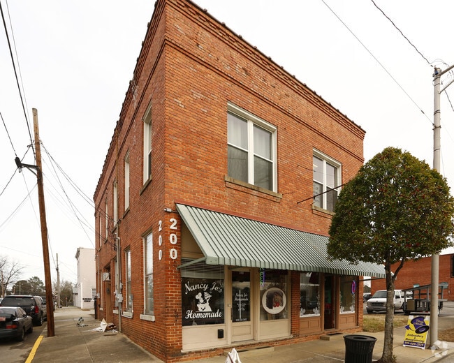
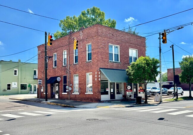
Property Record
200 E Main St, Clayton, NC 27520

NEARBY LISTINGS FOR SALE OR LEASE
Property Detail
200 E Main St
05015009
MAIN & CHURCH M15 L9 .04A166910-3
Commercialnec
Johnston
X
North Carolina
3720166900K
0.10 AC
0
Johnston County
2025
Raleigh/Durham
041004
Raleigh-Cary, NC
3,200 SF
DEMOGRAPHICS near 200 E Main St
1 Mile
3 Mile
5 Mile
2024 Total Population
8,375
32,376
63,431
2029 Population
10,340
39,567
77,138
Pop Growth 2024-2029
+ 23.46%
+ 22.21%
+ 21.61%
Average Age
38
38
38
2024 Total Households
3,449
12,568
23,316
HH Growth 2024-2029
+ 23.57%
+ 22.37%
+ 21.74%
Median Household Inc
$59,774
$68,240
$75,436
Avg Household Size
2.40
2.50
2.70
2024 Avg HH Vehicles
2.00
2.00
2.00
Median Home Value
$272,222
$258,550
$280,925
Median Year Built
1999
2001
2003
Nearby Places
Map Layers
Map Styles
 Street
 Aerial
- Restaurants
- Banks
- Shops
- Fitness
- Groceries
PUBLIC TRANSPORTATION
AIRPORT
Raleigh-Durham International
DRIVE
WALK
Distance
Raleigh-Durham International
43 min
30.8 mi
SALE & LEASE HISTORY
LISTING DATE
SALE/LEASE

May 14, 2025
For Lease
Mar 19, 2019
For Lease
Nearby Properties
Address
Land Use
TOTAL SIZE
Lot Size
Zoning
Address
Land Use
TOTAL SIZE
Lot Size
Zoning
76,128 SF
34.03 AC
OFF
Address
Land Use
TOTAL SIZE
Lot Size
Zoning
5,616 SF
22.46 AC
PUD
Address
Land Use
TOTAL SIZE
Lot Size
Zoning
22,428 SF
19.98 AC
COM
Address
Land Use
TOTAL SIZE
Lot Size
Zoning
691,230 SF
106.53 AC
IND
Address
Land Use
TOTAL SIZE
Lot Size
Zoning
5,038 SF
15.45 AC
COM
Address
Land Use
TOTAL SIZE
Lot Size
Zoning
46,266 SF
19.36 AC
COM
Address
Land Use
TOTAL SIZE
Lot Size
Zoning
27,636 SF
17.81 AC
PUD
Address
Land Use
TOTAL SIZE
Lot Size
Zoning
65,586 SF
15.48 AC
OFF
Address
Land Use
TOTAL SIZE
Lot Size
Zoning
298,354 SF
36.16 AC
IND
Address
Land Use
TOTAL SIZE
Lot Size
Zoning
118,430 SF
24.82 AC
IND
Address
Land Use
TOTAL SIZE
Lot Size
Zoning
24,552 SF
17.40 AC
RES
Address
Land Use
TOTAL SIZE
Lot Size
Zoning
72,416 SF
6.61 AC
COM
Address
Land Use
TOTAL SIZE
Lot Size
Zoning
85,447 SF
36.25 AC
RES
Address
Land Use
TOTAL SIZE
Lot Size
Zoning
84,379 SF
6.87 AC
PUD
Address
Land Use
TOTAL SIZE
Lot Size
Zoning
10,052 SF
11.33 AC
OFF
Address
Land Use
TOTAL SIZE
Lot Size
Zoning
97,500 SF
3.96 AC
COM
Address
Land Use
TOTAL SIZE
Lot Size
Zoning
282,196 SF
139.44 AC
IND
Address
Land Use
TOTAL SIZE
Lot Size
Zoning
201,003 SF
21.64 AC
SUP
Address
Land Use
TOTAL SIZE
Lot Size
Zoning
2,664 SF
448.85 AC
COM
Address
Land Use
TOTAL SIZE
Lot Size
Zoning
18,000 SF
249.20 AC
IND
Address
Land Use
TOTAL SIZE
Lot Size
Zoning
93,012 SF
3.11 AC
SUP
Address
Land Use
TOTAL SIZE
Lot Size
Zoning
67,730 SF
20.40 AC
RES
Address
Land Use
TOTAL SIZE
Lot Size
Zoning
13,308 SF
41.37 AC
OFF
Address
Land Use
TOTAL SIZE
Lot Size
Zoning
74,219 SF
15.88 AC
COM
Address
Land Use
TOTAL SIZE
Lot Size
Zoning
99,500 SF
8.07 AC
IND
Address
Land Use
TOTAL SIZE
Lot Size
Zoning
24,552 SF
8.05 AC
RES
Address
Land Use
TOTAL SIZE
Lot Size
Zoning
57,701 SF
4.93 AC
COM
Address
Land Use
TOTAL SIZE
Lot Size
Zoning
20,991 SF
16.69 AC
RES
Address
Land Use
TOTAL SIZE
Lot Size
Zoning
41,446 SF
7.92 AC
COM
Address
Land Use
TOTAL SIZE
Lot Size
Zoning
42,348 SF
9.10 AC
SUP
The World's #1 Commercial Real Estate Marketplace
Connect with us
© 2026 CoStar Group
The information above has been obtained from sources believed reliable. While we do not doubt its accuracy we have not verified it and make no guarantee, warranty or representation about it. It is your responsibility to independently confirm its accuracy and completeness. Any projections, opinions, assumptions, or estimates used are for example only and do not represent the current or future performance of the property. The value of this transaction to you depends on tax and other factors which should be evaluated by your tax, financial, and legal advisors. You and your advisors should conduct a careful, independent investigation of the property to determine to your satisfaction the suitability of the property for your needs.