Property Record
200 E Mountain St, Worcester, MA 01606
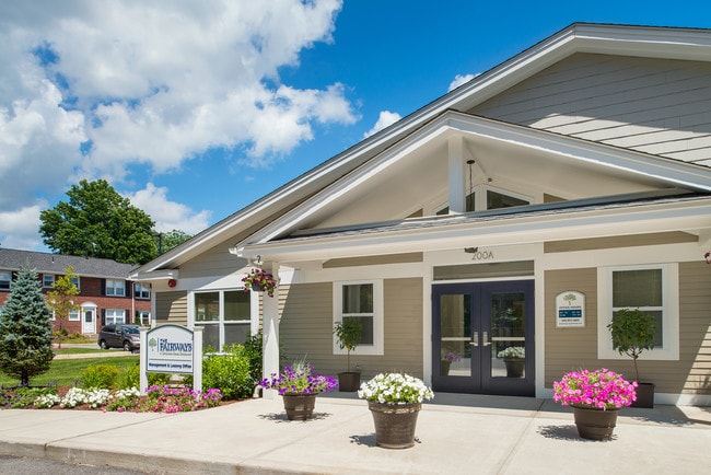

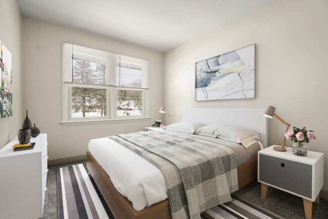
Property Detail
200 E Mountain St
WORC-000036-000049-000002
Worcester
Apartment
Massachusetts
RS-7
2
B and X Area of moderate flood hazard, usually the area between the limits of the 100-year and 500-year floods.
13.49 AC
2025
Burncoat
2025
Boston
730200
Worcester, MA
206,734 SF
NEARBY LISTINGS FOR SALE OR LEASE
-
-
View all Worcester listings for sale on LoopNet.com
DEMOGRAPHICS near 200 E Mountain St
1 mile
3 mile
5 mile
2025 Total Population
9,856
63,753
194,614
2030 Population
10,027
64,861
197,443
Pop Growth 2025-2030
+ 1.73%
+ 1.74%
+ 1.45%
Average Age
40
41
40
2025 Total Households
3,934
24,937
75,224
HH Growth 2025-2030
+ 1.83%
+ 1.80%
+ 1.52%
Median Household Inc
$76,965
$91,720
$85,379
Avg Household Size
2.40
2.40
2.40
2025 Avg HH Vehicles
1.00
2.00
2.00
Median Home Value
$368,708
$411,943
$453,109
Median Year Built
1953
1957
1955
Nearby Places
Map Layers
Map Styles
 Street
 Aerial
Transit
 Traffic
 Biking
Places
Listings with unknown addresses are not visible on the map
- Restaurants
- Banks
- Shops
- Fitness
- Groceries
PUBLIC TRANSPORTATION
COMMUTER RAIL
Worcester (Framingham/Worcester Line - Massachusetts Bay Transportation Authority Commuter Rail (Purple Line))
Drive
Walk
Distance
Worcester (Framingham/Worcester Line - Massachusetts Bay Transportation Authority Commuter Rail (Purple Line))
10 min
5.1 mi
Worcester Union Station (Lake Shore Limited - Amtrak)
Drive
Walk
Distance
Worcester Union Station (Lake Shore Limited - Amtrak)
9 min
5.2 mi
AIRPORT
Worcester Regional
Drive
Walk
Distance
Worcester Regional
19 min
9.3 mi
Freight Ports
Port of Boston
Drive
Walk
Distance
Port of Boston
65 min
43.8 mi
Nearby Properties
Address
Land Use
TOTAL SIZE
Lot Size
Zoning
Address
Land Use
TOTAL SIZE
Lot Size
Zoning
457,170 SF
29.92 AC
ML-.5
Address
Land Use
TOTAL SIZE
Lot Size
Zoning
20.01 AC
BG-2
Address
Land Use
TOTAL SIZE
Lot Size
Zoning
155,421 SF
65.04 AC
RL-7
Address
Land Use
TOTAL SIZE
Lot Size
Zoning
524,527 SF
45.16 AC
BL-1
Address
Land Use
TOTAL SIZE
Lot Size
Zoning
362,937 SF
91.58 AC
Address
Land Use
TOTAL SIZE
Lot Size
Zoning
51.05 AC
BO-1
Address
Land Use
TOTAL SIZE
Lot Size
Zoning
295,000 SF
194.17 AC
RUR B
Address
Land Use
TOTAL SIZE
Lot Size
Zoning
50.11 AC
RS-7
Address
Land Use
TOTAL SIZE
Lot Size
Zoning
126,849 SF
15.18 AC
R15
Address
Land Use
TOTAL SIZE
Lot Size
Zoning
30.93 AC
RG-5
Address
Land Use
TOTAL SIZE
Lot Size
Zoning
Address
Land Use
TOTAL SIZE
Lot Size
Zoning
291,410 SF
21.73 AC
RL-7
Address
Land Use
TOTAL SIZE
Lot Size
Zoning
194,264 SF
4.32 AC
BL-1
Address
Land Use
TOTAL SIZE
Lot Size
Zoning
15.37 AC
RS-7
Address
Land Use
TOTAL SIZE
Lot Size
Zoning
491,632 SF
1.59 AC
RL-7
Address
Land Use
TOTAL SIZE
Lot Size
Zoning
120,046 SF
6.90 AC
RG-5
Address
Land Use
TOTAL SIZE
Lot Size
Zoning
118,682 SF
7.33 AC
RG-5
Address
Land Use
TOTAL SIZE
Lot Size
Zoning
118,381 SF
12.61 AC
RG-5
Address
Land Use
TOTAL SIZE
Lot Size
Zoning
13.95 AC
RG-5
Address
Land Use
TOTAL SIZE
Lot Size
Zoning
217,500 SF
51.71 AC
LIM CO
Address
Land Use
TOTAL SIZE
Lot Size
Zoning
286,338 SF
33.45 AC
RL-7
Address
Land Use
TOTAL SIZE
Lot Size
Zoning
120,732 SF
28.92 AC
RS-10
Address
Land Use
TOTAL SIZE
Lot Size
Zoning
373,550 SF
29.05 AC
Address
Land Use
TOTAL SIZE
Lot Size
Zoning
153,482 SF
5.95 AC
MG-1
Address
Land Use
TOTAL SIZE
Lot Size
Zoning
6.70 AC
RG-5
Address
Land Use
TOTAL SIZE
Lot Size
Zoning
145,068 SF
16.35 AC
BG-3
Address
Land Use
TOTAL SIZE
Lot Size
Zoning
121,504 SF
3.75 AC
BG-3
Address
Land Use
TOTAL SIZE
Lot Size
Zoning
96,541 SF
5.24 AC
MG-5
Address
Land Use
TOTAL SIZE
Lot Size
Zoning
115,179 SF
5.62 AC
ML-.5
Address
Land Use
TOTAL SIZE
Lot Size
Zoning
24,243 SF
168.59 AC
The World's #1 Commercial Real Estate Marketplace
Connect with us
© 2026 CoStar Group
The information above has been obtained from sources believed reliable. While we do not doubt its accuracy we have not verified it and make no guarantee, warranty or representation about it. It is your responsibility to independently confirm its accuracy and completeness. Any projections, opinions, assumptions, or estimates used are for example only and do not represent the current or future performance of the property. The value of this transaction to you depends on tax and other factors which should be evaluated by your tax, financial, and legal advisors. You and your advisors should conduct a careful, independent investigation of the property to determine to your satisfaction the suitability of the property for your needs.