Property Record
200 E Stuart Roosa Dr, Claremore, OK 74017
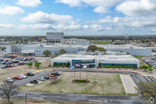

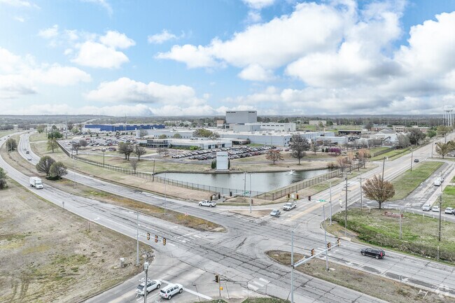
Property Detail
200 E Stuart Roosa Dr
660003272
TR S2 NE BEG: NE/C S2 NE; N 89-48-50 W ALG N/L THEREOF 1415' TO POB; S 0-15' W PAR TO E/L S2 NE 1274.42' TO PT 145' N TO A S/
Officebuilding
ROGERS
B and X Area of moderate flood hazard, usually the area between the limits of the 100-year and 500-year floods.
Oklahoma
2025
29.26 AC
2025
Rogers County
050304
Tulsa
30,872 SF
Tulsa, OK
NEARBY LISTINGS FOR SALE OR LEASE
DEMOGRAPHICS near 200 E Stuart Roosa Dr
1 mile
3 mile
5 mile
2025 Total Population
3,753
23,266
33,764
2030 Population
3,960
24,622
35,680
Pop Growth 2025-2030
+ 5.52%
+ 5.83%
+ 5.67%
Average Age
42
40
40
2025 Total Households
1,555
9,032
12,954
HH Growth 2025-2030
+ 5.59%
+ 5.95%
+ 5.79%
Median Household Inc
$57,725
$57,550
$61,325
Avg Household Size
2.30
2.40
2.40
2025 Avg HH Vehicles
2.00
2.00
2.00
Median Home Value
$187,389
$196,938
$222,473
Median Year Built
1978
1982
1986
Nearby Places
Map Layers
Map Styles
 Street
 Aerial
Layers
 Traffic
 Biking
Places
Listings with unknown addresses are not visible on the map
- Restaurants
- Banks
- Shops
- Fitness
- Groceries
PUBLIC TRANSPORTATION
AIRPORT
Tulsa International
Drive
Walk
Distance
Tulsa International
33 min
21.7 mi
Freight Ports
Tulsa Port Of Catoosa
Drive
Walk
Distance
Tulsa Port Of Catoosa
22 min
13.8 mi
Nearby Properties
Address
Land Use
TOTAL SIZE
Lot Size
Zoning
Address
Land Use
TOTAL SIZE
Lot Size
Zoning
24,886 SF
2.05 AC
Address
Land Use
TOTAL SIZE
Lot Size
Zoning
2,000 SF
13.81 AC
Address
Land Use
TOTAL SIZE
Lot Size
Zoning
35,022 SF
3.94 AC
Address
Land Use
TOTAL SIZE
Lot Size
Zoning
32,000 SF
Address
Land Use
TOTAL SIZE
Lot Size
Zoning
15,680 SF
10.72 AC
Address
Land Use
TOTAL SIZE
Lot Size
Zoning
5,096 SF
7.27 AC
Address
Land Use
TOTAL SIZE
Lot Size
Zoning
51,048 SF
Address
Land Use
TOTAL SIZE
Lot Size
Zoning
173,000 SF
18.49 AC
Address
Land Use
TOTAL SIZE
Lot Size
Zoning
60,266 SF
7.91 AC
Address
Land Use
TOTAL SIZE
Lot Size
Zoning
60,037 SF
6.84 AC
Address
Land Use
TOTAL SIZE
Lot Size
Zoning
7,182 SF
1.15 AC
Address
Land Use
TOTAL SIZE
Lot Size
Zoning
14,724 SF
5.80 AC
Address
Land Use
TOTAL SIZE
Lot Size
Zoning
115,699 SF
5.18 AC
Address
Land Use
TOTAL SIZE
Lot Size
Zoning
42,147 SF
1.33 AC
Address
Land Use
TOTAL SIZE
Lot Size
Zoning
6,400 SF
0.27 AC
Address
Land Use
TOTAL SIZE
Lot Size
Zoning
44,160 SF
4.11 AC
Address
Land Use
TOTAL SIZE
Lot Size
Zoning
40,738 SF
3.55 AC
Address
Land Use
TOTAL SIZE
Lot Size
Zoning
450 SF
16.43 AC
Address
Land Use
TOTAL SIZE
Lot Size
Zoning
3,186 SF
0.14 AC
Address
Land Use
TOTAL SIZE
Lot Size
Zoning
35,700 SF
Address
Land Use
TOTAL SIZE
Lot Size
Zoning
5,700 SF
1.01 AC
Address
Land Use
TOTAL SIZE
Lot Size
Zoning
418 SF
7.50 AC
Address
Land Use
TOTAL SIZE
Lot Size
Zoning
3,705 SF
8.50 AC
Address
Land Use
TOTAL SIZE
Lot Size
Zoning
1,400 SF
2.16 AC
Address
Land Use
TOTAL SIZE
Lot Size
Zoning
45,568 SF
5.20 AC
Address
Land Use
TOTAL SIZE
Lot Size
Zoning
75,840 SF
11.10 AC
Address
Land Use
TOTAL SIZE
Lot Size
Zoning
168,245 SF
16.74 AC
Address
Land Use
TOTAL SIZE
Lot Size
Zoning
28,548 SF
0.99 AC
Address
Land Use
TOTAL SIZE
Lot Size
Zoning
106,657 SF
5.70 AC
The World's #1 Commercial Real Estate Marketplace
Connect with us
© 2026 CoStar Group
The information above has been obtained from sources believed reliable. While we do not doubt its accuracy we have not verified it and make no guarantee, warranty or representation about it. It is your responsibility to independently confirm its accuracy and completeness. Any projections, opinions, assumptions, or estimates used are for example only and do not represent the current or future performance of the property. The value of this transaction to you depends on tax and other factors which should be evaluated by your tax, financial, and legal advisors. You and your advisors should conduct a careful, independent investigation of the property to determine to your satisfaction the suitability of the property for your needs.