Property Record
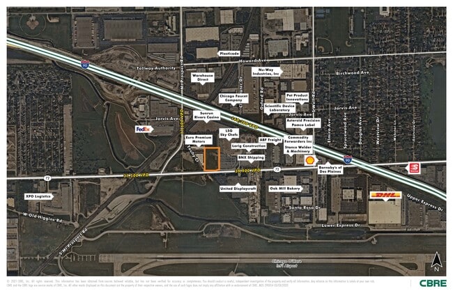
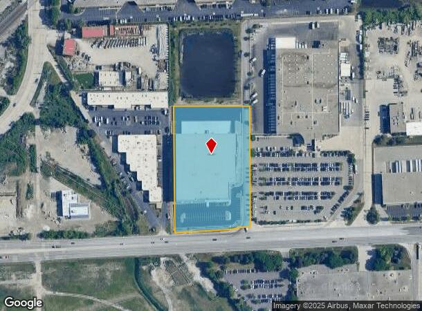
190 E Touhy Ave, Des Plaines, IL 60018


NEARBY LISTINGS FOR SALE OR LEASE
Property Detail
190 E Touhy Ave
09-30-301-002-0000
200 East Touhy Resubdivision
Industrialgeneral
Cook
X
Illinois
17031C0218J
3.81 AC
2023
O'Hare
2025
Chicago
770602
Chicago-Naperville-Elgin, IL-IN
DEMOGRAPHICS near 190 E Touhy Ave
1 Mile
3 Mile
5 Mile
2024 Total Population
3,725
75,602
264,714
2029 Population
3,580
73,348
257,128
Pop Growth 2024-2029
(3.89%)
(2.98%)
(2.87%)
Average Age
39
41
42
2024 Total Households
1,157
29,329
101,556
HH Growth 2024-2029
(3.98%)
(3.23%)
(3.16%)
Median Household Inc
$71,321
$71,754
$79,786
Avg Household Size
3.20
2.50
2.50
2024 Avg HH Vehicles
2.00
2.00
2.00
Median Home Value
$247,706
$280,798
$318,244
Median Year Built
1981
1970
1968
Nearby Places
Map Layers
Map Styles
 Street
 Aerial
- Restaurants
- Banks
- Shops
- Fitness
- Groceries
PUBLIC TRANSPORTATION
COMMUTER RAIL
O'Hare Transfer Station (North Central Service - Northeast Illinois Regional Commuter Railroad (Metra))
DRIVE
WALK
Distance
O'Hare Transfer Station (North Central Service - Northeast Illinois Regional Commuter Railroad (Metra))
8 min
2.7 mi
Cumberland Station (Union Pacific Northwest Line - Northeast Illinois Regional Commuter Railroad (Metra))
DRIVE
WALK
Distance
Cumberland Station (Union Pacific Northwest Line - Northeast Illinois Regional Commuter Railroad (Metra))
10 min
3.8 mi
AIRPORT
Chicago O'Hare International
DRIVE
WALK
Distance
Chicago O'Hare International
11 min
5.2 mi
Chicago Midway International
DRIVE
WALK
Distance
Chicago Midway International
39 min
28.3 mi
SALE & LEASE HISTORY
LISTING DATE
SALE/LEASE

Mar 23, 2021
For Sale
Nearby Properties
Address
Land Use
TOTAL SIZE
Lot Size
Zoning
Address
Land Use
TOTAL SIZE
Lot Size
Zoning
1,127,595 SF
Address
Land Use
TOTAL SIZE
Lot Size
Zoning
Address
Land Use
TOTAL SIZE
Lot Size
Zoning
310,751 SF
15.04 AC
Address
Land Use
TOTAL SIZE
Lot Size
Zoning
333,258 SF
9.48 AC
Address
Land Use
TOTAL SIZE
Lot Size
Zoning
108,216 SF
7.87 AC
Address
Land Use
TOTAL SIZE
Lot Size
Zoning
53,760 SF
5.36 AC
Address
Land Use
TOTAL SIZE
Lot Size
Zoning
410,822 SF
14.26 AC
Address
Land Use
TOTAL SIZE
Lot Size
Zoning
208,000 SF
10.35 AC
Address
Land Use
TOTAL SIZE
Lot Size
Zoning
132,699 SF
6.74 AC
Address
Land Use
TOTAL SIZE
Lot Size
Zoning
179,780 SF
8.12 AC
I
Address
Land Use
TOTAL SIZE
Lot Size
Zoning
58,373 SF
11.22 AC
Address
Land Use
TOTAL SIZE
Lot Size
Zoning
17.67 AC
Address
Land Use
TOTAL SIZE
Lot Size
Zoning
74,664 SF
3.19 AC
Address
Land Use
TOTAL SIZE
Lot Size
Zoning
14.76 AC
Address
Land Use
TOTAL SIZE
Lot Size
Zoning
Address
Land Use
TOTAL SIZE
Lot Size
Zoning
15.32 AC
Address
Land Use
TOTAL SIZE
Lot Size
Zoning
15.29 AC
Address
Land Use
TOTAL SIZE
Lot Size
Zoning
132,574 SF
5.91 AC
Address
Land Use
TOTAL SIZE
Lot Size
Zoning
Address
Land Use
TOTAL SIZE
Lot Size
Zoning
112,000 SF
Address
Land Use
TOTAL SIZE
Lot Size
Zoning
688,900 SF
20.91 AC
Address
Land Use
TOTAL SIZE
Lot Size
Zoning
270,512 SF
2.26 AC
Address
Land Use
TOTAL SIZE
Lot Size
Zoning
533,629 SF
24.19 AC
Address
Land Use
TOTAL SIZE
Lot Size
Zoning
Address
Land Use
TOTAL SIZE
Lot Size
Zoning
29,850 SF
37.75 AC
Address
Land Use
TOTAL SIZE
Lot Size
Zoning
13.44 AC
Address
Land Use
TOTAL SIZE
Lot Size
Zoning
108,972 SF
5.65 AC
Address
Land Use
TOTAL SIZE
Lot Size
Zoning
Address
Land Use
TOTAL SIZE
Lot Size
Zoning
413,338 SF
23.92 AC
Address
Land Use
TOTAL SIZE
Lot Size
Zoning
72,504 SF
1.70 AC
The World's #1 Commercial Real Estate Marketplace
Connect with us
© 2026 CoStar Group
The information above has been obtained from sources believed reliable. While we do not doubt its accuracy we have not verified it and make no guarantee, warranty or representation about it. It is your responsibility to independently confirm its accuracy and completeness. Any projections, opinions, assumptions, or estimates used are for example only and do not represent the current or future performance of the property. The value of this transaction to you depends on tax and other factors which should be evaluated by your tax, financial, and legal advisors. You and your advisors should conduct a careful, independent investigation of the property to determine to your satisfaction the suitability of the property for your needs.