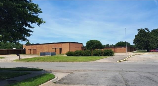
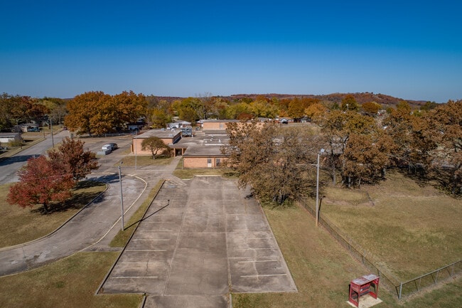
Property Record
200 Forrest Park Rd, Bartlesville, OK 74003

NEARBY LISTINGS FOR SALE OR LEASE
-
-
View all Bartlesville listings for sale on LoopNet.com
Property Detail
200 Forrest Park Rd
0024281
Oak Park Village S5
Publicschool
ALL BLK 52 OAK PARK VILLAGE S5 LESS THE NE 147'
X
Washington
40147C0115D
Oklahoma
2024
6.73 AC
2025
Bartlesville
000100
Tulsa
38,170 SF
Bartlesville, OK
DEMOGRAPHICS near 200 Forrest Park Rd
1 Mile
3 Mile
5 Mile
2024 Total Population
1,908
12,126
34,297
2029 Population
1,999
12,920
36,148
Pop Growth 2024-2029
+ 4.77%
+ 6.55%
+ 5.40%
Average Age
36
38
40
2024 Total Households
700
4,979
13,886
HH Growth 2024-2029
+ 4.71%
+ 6.69%
+ 5.39%
Median Household Inc
$51,000
$36,843
$48,140
Avg Household Size
2.60
2.30
2.30
2024 Avg HH Vehicles
2.00
2.00
2.00
Median Home Value
$57,568
$75,013
$126,381
Median Year Built
1965
1955
1962
Nearby Places
Map Layers
Map Styles
 Street
 Aerial
- Restaurants
- Banks
- Shops
- Fitness
- Groceries
SALE & LEASE HISTORY
LISTING DATE
SALE/LEASE

Nov 19, 2020
For Sale
May 21, 2025
For Sale
Jul 05, 2017
For Sale
Dec 19, 2016
For Sale
Nearby Properties
Address
Land Use
TOTAL SIZE
Lot Size
Zoning
Address
Land Use
TOTAL SIZE
Lot Size
Zoning
28,384 SF
0.48 AC
AA1
Address
Land Use
TOTAL SIZE
Lot Size
Zoning
390,750 SF
1.55 AC
AA1
Address
Land Use
TOTAL SIZE
Lot Size
Zoning
116,550 SF
0.32 AC
AA1
Address
Land Use
TOTAL SIZE
Lot Size
Zoning
336,066 SF
2.41 AC
AA1
Address
Land Use
TOTAL SIZE
Lot Size
Zoning
4,962 SF
0.48 AC
AA1
Address
Land Use
TOTAL SIZE
Lot Size
Zoning
2,409 SF
2.07 AC
AA1
Address
Land Use
TOTAL SIZE
Lot Size
Zoning
243,155 SF
0.61 AC
AA1
Address
Land Use
TOTAL SIZE
Lot Size
Zoning
56,750 SF
0.32 AC
AA1
Address
Land Use
TOTAL SIZE
Lot Size
Zoning
156,600 SF
2.41 AC
AA1
Address
Land Use
TOTAL SIZE
Lot Size
Zoning
5,000 SF
2.32 AC
AA1
Address
Land Use
TOTAL SIZE
Lot Size
Zoning
40,704 SF
2.49 AC
AA1
Address
Land Use
TOTAL SIZE
Lot Size
Zoning
6,520 SF
1.85 AC
AA1
Address
Land Use
TOTAL SIZE
Lot Size
Zoning
12,000 SF
0.16 AC
AA1
Address
Land Use
TOTAL SIZE
Lot Size
Zoning
101,122 SF
1.10 AC
AA1
Address
Land Use
TOTAL SIZE
Lot Size
Zoning
81,500 SF
1.55 AC
AA1
Address
Land Use
TOTAL SIZE
Lot Size
Zoning
12,546 SF
0.35 AC
AA1
Address
Land Use
TOTAL SIZE
Lot Size
Zoning
6,150 SF
0.96 AC
AA1
Address
Land Use
TOTAL SIZE
Lot Size
Zoning
37,044 SF
0.16 AC
AA1
Address
Land Use
TOTAL SIZE
Lot Size
Zoning
179,323 SF
2.07 AC
AA1
Address
Land Use
TOTAL SIZE
Lot Size
Zoning
24,712 SF
18.08 AC
AA1
Address
Land Use
TOTAL SIZE
Lot Size
Zoning
39,158 SF
1.03 AC
AA1
Address
Land Use
TOTAL SIZE
Lot Size
Zoning
7,500 SF
0.31 AC
AA1
Address
Land Use
TOTAL SIZE
Lot Size
Zoning
15,300 SF
0.19 AC
AA1
Address
Land Use
TOTAL SIZE
Lot Size
Zoning
10,872 SF
0.14 AC
AA1
Address
Land Use
TOTAL SIZE
Lot Size
Zoning
4,440 SF
1.99 AC
AA1
Address
Land Use
TOTAL SIZE
Lot Size
Zoning
319,865 SF
Address
Land Use
TOTAL SIZE
Lot Size
Zoning
51,000 SF
1.86 AC
AA1
Address
Land Use
TOTAL SIZE
Lot Size
Zoning
8,845 SF
0.06 AC
AA1
Address
Land Use
TOTAL SIZE
Lot Size
Zoning
116,625 SF
27.02 AC
The World's #1 Commercial Real Estate Marketplace
Connect with us
© 2025 CoStar Group
The information above has been obtained from sources believed reliable. While we do not doubt its accuracy we have not verified it and make no guarantee, warranty or representation about it. It is your responsibility to independently confirm its accuracy and completeness. Any projections, opinions, assumptions, or estimates used are for example only and do not represent the current or future performance of the property. The value of this transaction to you depends on tax and other factors which should be evaluated by your tax, financial, and legal advisors. You and your advisors should conduct a careful, independent investigation of the property to determine to your satisfaction the suitability of the property for your needs.