Property Record
200 Frank Dimino Way, Rochester, NY 14624

NEARBY LISTINGS FOR SALE OR LEASE
-
-
View all Rochester listings for sale on LoopNet.com
Property Detail
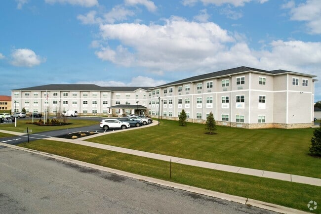
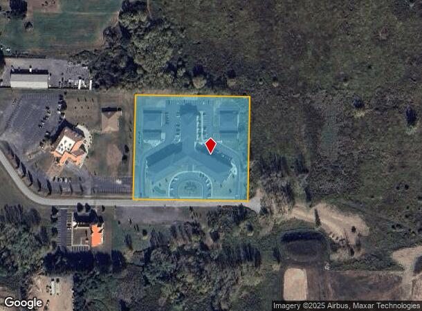
200 Frank Dimino Way
262600 118.13-1-8.32
Villa Capri Subdivision Plan
Apartment
Monroe
X
New York
36055C0169G
8.320
2025
4.70 AC
2024
Outer West/Southwest Monroe County
014202
Rochester
85,932 SF
Rochester, NY
DEMOGRAPHICS near 200 Frank Dimino Way
1 Mile
3 Mile
5 Mile
2024 Total Population
4,370
42,171
92,531
2029 Population
4,365
41,562
91,166
Pop Growth 2024-2029
(0.11%)
(1.44%)
(1.48%)
Average Age
42
43
42
2024 Total Households
1,977
17,524
38,696
HH Growth 2024-2029
(0.51%)
(1.56%)
(1.57%)
Median Household Inc
$67,960
$74,766
$71,744
Avg Household Size
2.20
2.30
2.30
2024 Avg HH Vehicles
2.00
2.00
2.00
Median Home Value
$183,874
$162,374
$158,744
Median Year Built
1989
1973
1970
Nearby Places
Map Layers
Map Styles
 Street
 Aerial
- Restaurants
- Banks
- Shops
- Fitness
- Groceries
PUBLIC TRANSPORTATION
COMMUTER RAIL
Rochester (Empire Service - VIA Rail, Lake Shore Limited - VIA Rail, Maple Leaf - VIA Rail, Toronto - New York - VIA Rail)
DRIVE
WALK
Distance
Rochester (Empire Service - VIA Rail, Lake Shore Limited - VIA Rail, Maple Leaf - VIA Rail, Toronto - New York - VIA Rail)
16 min
9.3 mi
AIRPORT
Frederick Douglass/Greater Rochester International
DRIVE
WALK
Distance
Frederick Douglass/Greater Rochester International
15 min
9.1 mi
Freight Ports
Albany, NY Port
DRIVE
WALK
Distance
Albany, NY Port
281 min
235.4 mi
Nearby Properties
Address
Land Use
TOTAL SIZE
Lot Size
Zoning
Address
Land Use
TOTAL SIZE
Lot Size
Zoning
796,051 SF
100.85 AC
06 - INDUS
Address
Land Use
TOTAL SIZE
Lot Size
Zoning
348,895 SF
76.07 AC
06 - INDUS
Address
Land Use
TOTAL SIZE
Lot Size
Zoning
9,820 SF
52.52 AC
02 - SINGL
Address
Land Use
TOTAL SIZE
Lot Size
Zoning
11,408 SF
98.28 AC
02 - SINGL
Address
Land Use
TOTAL SIZE
Lot Size
Zoning
280,300 SF
71.39 AC
LI
Address
Land Use
TOTAL SIZE
Lot Size
Zoning
20,544 SF
25.87 AC
R-1
Address
Land Use
TOTAL SIZE
Lot Size
Zoning
63,134 SF
7.46 AC
02 - SINGL
Address
Land Use
TOTAL SIZE
Lot Size
Zoning
671,599 SF
33.10 AC
06 - INDUS
Address
Land Use
TOTAL SIZE
Lot Size
Zoning
109,772 SF
10.42 AC
06 - INDUS
Address
Land Use
TOTAL SIZE
Lot Size
Zoning
97,320 SF
19.54 AC
05 - COMME
Address
Land Use
TOTAL SIZE
Lot Size
Zoning
14,268 SF
36.20 AC
MFR
Address
Land Use
TOTAL SIZE
Lot Size
Zoning
99,886 SF
18.28 AC
05 - COMME
Address
Land Use
TOTAL SIZE
Lot Size
Zoning
22,116 SF
42.83 AC
02 - SINGL
Address
Land Use
TOTAL SIZE
Lot Size
Zoning
6,960 SF
20.31 AC
02 - SINGL
Address
Land Use
TOTAL SIZE
Lot Size
Zoning
119,706 SF
16.43 AC
05 - COMME
Address
Land Use
TOTAL SIZE
Lot Size
Zoning
127,786 SF
11.31 AC
05 - COMME
Address
Land Use
TOTAL SIZE
Lot Size
Zoning
23,940 SF
6.45 AC
05 - COMME
Address
Land Use
TOTAL SIZE
Lot Size
Zoning
121,843 SF
3.05 AC
02 - SINGL
Address
Land Use
TOTAL SIZE
Lot Size
Zoning
87,106 SF
8.66 AC
SC
Address
Land Use
TOTAL SIZE
Lot Size
Zoning
9,556 SF
21.24 AC
MFR
Address
Land Use
TOTAL SIZE
Lot Size
Zoning
4,448 SF
18.78 AC
05 - COMME
Address
Land Use
TOTAL SIZE
Lot Size
Zoning
186,687 SF
13.90 AC
LI
Address
Land Use
TOTAL SIZE
Lot Size
Zoning
62,915 SF
6.77 AC
02 - SINGL
Address
Land Use
TOTAL SIZE
Lot Size
Zoning
0.91 AC
06 - INDUS
Address
Land Use
TOTAL SIZE
Lot Size
Zoning
56,848 SF
28.90 AC
06 - INDUS
Address
Land Use
TOTAL SIZE
Lot Size
Zoning
128,938 SF
36.11 AC
06 - INDUS
Address
Land Use
TOTAL SIZE
Lot Size
Zoning
116,193 SF
12.23 AC
05 - COMME
Address
Land Use
TOTAL SIZE
Lot Size
Zoning
143,325 SF
12.20 AC
LI
Address
Land Use
TOTAL SIZE
Lot Size
Zoning
11,200 SF
5.67 AC
06 - INDUS
The World's #1 Commercial Real Estate Marketplace
Connect with us
© 2026 CoStar Group
The information above has been obtained from sources believed reliable. While we do not doubt its accuracy we have not verified it and make no guarantee, warranty or representation about it. It is your responsibility to independently confirm its accuracy and completeness. Any projections, opinions, assumptions, or estimates used are for example only and do not represent the current or future performance of the property. The value of this transaction to you depends on tax and other factors which should be evaluated by your tax, financial, and legal advisors. You and your advisors should conduct a careful, independent investigation of the property to determine to your satisfaction the suitability of the property for your needs.