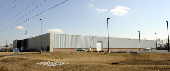
Property Record
200 Fullerton Ave, Carol Stream, IL 60188

Property Detail
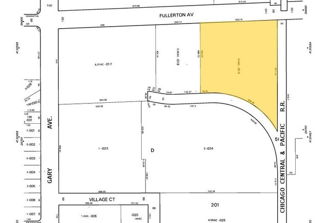
200 Fullerton Ave
02-32-201-014
E 433.16FT NW 1/4 NE 1/4 LYG N & W OF I C RR LEAD TRACK /EX HWY DED BY DOC R76- 08477/
Industrialgeneral
DuPage
I
Illinois
B and X Area of moderate flood hazard, usually the area between the limits of the 100-year and 500-year floods.
4.50 AC
2024
North DuPage
2024
Chicago
841208
Chicago-Naperville-Elgin, IL-IN
66,254 SF
NEARBY LISTINGS FOR SALE OR LEASE
DEMOGRAPHICS near 200 Fullerton Ave
1 mile
3 mile
5 mile
2025 Total Population
9,214
104,390
246,680
2030 Population
9,293
104,890
248,308
Pop Growth 2025-2030
+ 0.86%
+ 0.48%
+ 0.66%
Average Age
39
40
41
2025 Total Households
3,397
36,800
87,744
HH Growth 2025-2030
+ 0.77%
+ 0.51%
+ 0.66%
Median Household Inc
$90,676
$105,446
$108,746
Avg Household Size
2.60
2.70
2.70
2025 Avg HH Vehicles
2.00
2.00
2.00
Median Home Value
$287,986
$333,520
$356,467
Median Year Built
1979
1980
1977
Nearby Places
Map Layers
Map Styles
 Street
 Aerial
Layers
 Traffic
 Biking
Places
Listings with unknown addresses are not visible on the map
- Restaurants
- Banks
- Shops
- Fitness
- Groceries
PUBLIC TRANSPORTATION
COMMUTER RAIL
Wheaton Station (Union Pacific West Line - Northeast Illinois Regional Commuter Railroad (Metra))
Drive
Walk
Distance
Wheaton Station (Union Pacific West Line - Northeast Illinois Regional Commuter Railroad (Metra))
10 min
4.1 mi
College Avenue Station (Union Pacific West Line - Northeast Illinois Regional Commuter Railroad (Metra))
Drive
Walk
Distance
College Avenue Station (Union Pacific West Line - Northeast Illinois Regional Commuter Railroad (Metra))
13 min
5.1 mi
AIRPORT
Chicago O'Hare International
Drive
Walk
Distance
Chicago O'Hare International
36 min
20.4 mi
Chicago Midway International
Drive
Walk
Distance
Chicago Midway International
44 min
26.4 mi
Nearby Properties
Address
Land Use
TOTAL SIZE
Lot Size
Zoning
Address
Land Use
TOTAL SIZE
Lot Size
Zoning
693,153 SF
46.17 AC
Address
Land Use
TOTAL SIZE
Lot Size
Zoning
345,600 SF
23.40 AC
M
Address
Land Use
TOTAL SIZE
Lot Size
Zoning
260,424 SF
16.87 AC
M
Address
Land Use
TOTAL SIZE
Lot Size
Zoning
322,680 SF
19.07 AC
M
Address
Land Use
TOTAL SIZE
Lot Size
Zoning
268,400 SF
15.87 AC
M
Address
Land Use
TOTAL SIZE
Lot Size
Zoning
236,871 SF
12.84 AC
M
Address
Land Use
TOTAL SIZE
Lot Size
Zoning
235,131 SF
14.18 AC
I
Address
Land Use
TOTAL SIZE
Lot Size
Zoning
258,793 SF
16.44 AC
M
Address
Land Use
TOTAL SIZE
Lot Size
Zoning
251,091 SF
32.67 AC
R-4
Address
Land Use
TOTAL SIZE
Lot Size
Zoning
9.34 AC
M
Address
Land Use
TOTAL SIZE
Lot Size
Zoning
16.91 AC
C
Address
Land Use
TOTAL SIZE
Lot Size
Zoning
216,720 SF
12.40 AC
M
Address
Land Use
TOTAL SIZE
Lot Size
Zoning
290,280 SF
14 AC
Address
Land Use
TOTAL SIZE
Lot Size
Zoning
204,464 SF
16.53 AC
Address
Land Use
TOTAL SIZE
Lot Size
Zoning
515,497 SF
21.98 AC
I
Address
Land Use
TOTAL SIZE
Lot Size
Zoning
527,079 SF
29.01 AC
I
Address
Land Use
TOTAL SIZE
Lot Size
Zoning
149,460 SF
10.62 AC
M
Address
Land Use
TOTAL SIZE
Lot Size
Zoning
226,069 SF
14.85 AC
Address
Land Use
TOTAL SIZE
Lot Size
Zoning
367,020 SF
26.13 AC
I
Address
Land Use
TOTAL SIZE
Lot Size
Zoning
582,089 SF
41.71 AC
C
Address
Land Use
TOTAL SIZE
Lot Size
Zoning
381,600 SF
24.47 AC
Address
Land Use
TOTAL SIZE
Lot Size
Zoning
304,976 SF
23.98 AC
Address
Land Use
TOTAL SIZE
Lot Size
Zoning
400,032 SF
21.12 AC
I
Address
Land Use
TOTAL SIZE
Lot Size
Zoning
436,765 SF
7 AC
M
Address
Land Use
TOTAL SIZE
Lot Size
Zoning
311,052 SF
20.97 AC
M
Address
Land Use
TOTAL SIZE
Lot Size
Zoning
393,516 SF
18.08 AC
I
Address
Land Use
TOTAL SIZE
Lot Size
Zoning
347,400 SF
15.31 AC
I
Address
Land Use
TOTAL SIZE
Lot Size
Zoning
352,089 SF
21.13 AC
I
Address
Land Use
TOTAL SIZE
Lot Size
Zoning
6.20 AC
M
Address
Land Use
TOTAL SIZE
Lot Size
Zoning
302,986 SF
16.04 AC
The World's #1 Commercial Real Estate Marketplace
Connect with us
© 2026 CoStar Group
The information above has been obtained from sources believed reliable. While we do not doubt its accuracy we have not verified it and make no guarantee, warranty or representation about it. It is your responsibility to independently confirm its accuracy and completeness. Any projections, opinions, assumptions, or estimates used are for example only and do not represent the current or future performance of the property. The value of this transaction to you depends on tax and other factors which should be evaluated by your tax, financial, and legal advisors. You and your advisors should conduct a careful, independent investigation of the property to determine to your satisfaction the suitability of the property for your needs.