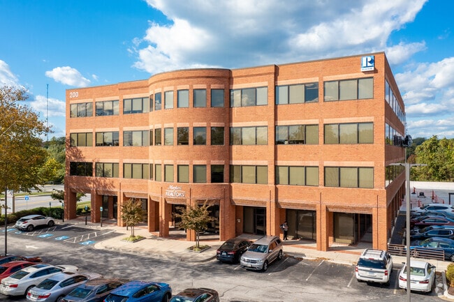
Property Record
200 Harry S Truman Pky, Annapolis, MD 21401

Current Lease Availabilities
NEARBY LISTINGS FOR SALE OR LEASE
Property Detail
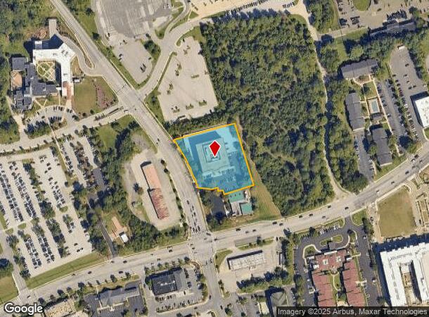
200 Harry S Truman Pky
Baltimore-Columbia-Towson, MD
Riva
02-000-90070068
LT 1B OR 1.4172 ACRE RIVA
Officebuilding
Anne Arundel
X
Maryland
24003C0231F
1b
2024
1.41 AC
2025
Annapolis
702402
Baltimore
109,482 SF
DEMOGRAPHICS near 200 Harry S Truman Pky
1 Mile
3 Mile
5 Mile
2024 Total Population
5,273
50,824
101,833
2029 Population
5,398
52,068
104,646
Pop Growth 2024-2029
+ 2.37%
+ 2.45%
+ 2.76%
Average Age
47
44
43
2024 Total Households
2,682
21,385
41,820
HH Growth 2024-2029
+ 2.31%
+ 2.51%
+ 2.87%
Median Household Inc
$129,925
$114,726
$115,817
Avg Household Size
1.90
2.30
2.40
2024 Avg HH Vehicles
2.00
2.00
2.00
Median Home Value
$663,158
$487,322
$551,481
Median Year Built
1992
1984
1980
Nearby Places
- Restaurants
- Banks
- Shops
- Fitness
- Groceries
PUBLIC TRANSPORTATION
AIRPORT
Baltimore/Washington International Thurgood Marshall
DRIVE
WALK
Distance
Baltimore/Washington International Thurgood Marshall
30 min
21.5 mi
Ronald Reagan Washington Ntl
DRIVE
WALK
Distance
Ronald Reagan Washington Ntl
46 min
33.2 mi
Freight Ports
Port of Baltimore
DRIVE
WALK
Distance
Port of Baltimore
38 min
27.1 mi
Nearby Properties
Address
Land Use
TOTAL SIZE
Lot Size
Zoning
Address
Land Use
TOTAL SIZE
Lot Size
Zoning
2,568,175 SF
55.32 AC
TC
Address
Land Use
TOTAL SIZE
Lot Size
Zoning
717,491 SF
26.28 AC
C2
Address
Land Use
TOTAL SIZE
Lot Size
Zoning
406,976 SF
18.98 AC
R2
Address
Land Use
TOTAL SIZE
Lot Size
Zoning
58.99 AC
R2
Address
Land Use
TOTAL SIZE
Lot Size
Zoning
296,790 SF
27.74 AC
TC
Address
Land Use
TOTAL SIZE
Lot Size
Zoning
313,440 SF
23.43 AC
TC
Address
Land Use
TOTAL SIZE
Lot Size
Zoning
441,482 SF
3.85 AC
W1
Address
Land Use
TOTAL SIZE
Lot Size
Zoning
577,560 SF
3.71 AC
C2
Address
Land Use
TOTAL SIZE
Lot Size
Zoning
346,335 SF
16.42 AC
R22
Address
Land Use
TOTAL SIZE
Lot Size
Zoning
419,712 SF
9.48 AC
R2
Address
Land Use
TOTAL SIZE
Lot Size
Zoning
389,081 SF
4.79 AC
TC
Address
Land Use
TOTAL SIZE
Lot Size
Zoning
591,962 SF
6.43 AC
BCE
Address
Land Use
TOTAL SIZE
Lot Size
Zoning
271,003 SF
1 AC
TC
Address
Land Use
TOTAL SIZE
Lot Size
Zoning
365,268 SF
4.85 AC
W1
Address
Land Use
TOTAL SIZE
Lot Size
Zoning
198,795 SF
36 AC
R2
Address
Land Use
TOTAL SIZE
Lot Size
Zoning
97,888 SF
59.42 AC
C2
Address
Land Use
TOTAL SIZE
Lot Size
Zoning
341,468 SF
1.82 AC
TC
Address
Land Use
TOTAL SIZE
Lot Size
Zoning
435,081 SF
2.62 AC
TC
Address
Land Use
TOTAL SIZE
Lot Size
Zoning
315,260 SF
22.82 AC
C2
Address
Land Use
TOTAL SIZE
Lot Size
Zoning
248,820 SF
24.92 AC
R2
Address
Land Use
TOTAL SIZE
Lot Size
Zoning
309,756 SF
0.01 AC
R-22
Address
Land Use
TOTAL SIZE
Lot Size
Zoning
285,174 SF
24 AC
R2
Address
Land Use
TOTAL SIZE
Lot Size
Zoning
194,155 SF
6.69 AC
R1
Address
Land Use
TOTAL SIZE
Lot Size
Zoning
254,969 SF
13.73 AC
W1A
Address
Land Use
TOTAL SIZE
Lot Size
Zoning
189,134 SF
1.02 AC
MX
Address
Land Use
TOTAL SIZE
Lot Size
Zoning
73.33 AC
R2
Address
Land Use
TOTAL SIZE
Lot Size
Zoning
104,950 SF
2.93 AC
TC
Address
Land Use
TOTAL SIZE
Lot Size
Zoning
389,242 SF
11.56 AC
C2
Address
Land Use
TOTAL SIZE
Lot Size
Zoning
117,577 SF
6.92 AC
R2
Address
Land Use
TOTAL SIZE
Lot Size
Zoning
37.74 AC
R3
The World's #1 Commercial Real Estate Marketplace
Connect with us
© 2025 CoStar Group
The information above has been obtained from sources believed reliable. While we do not doubt its accuracy we have not verified it and make no guarantee, warranty or representation about it. It is your responsibility to independently confirm its accuracy and completeness. Any projections, opinions, assumptions, or estimates used are for example only and do not represent the current or future performance of the property. The value of this transaction to you depends on tax and other factors which should be evaluated by your tax, financial, and legal advisors. You and your advisors should conduct a careful, independent investigation of the property to determine to your satisfaction the suitability of the property for your needs.