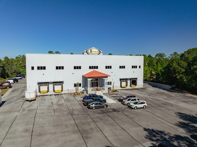
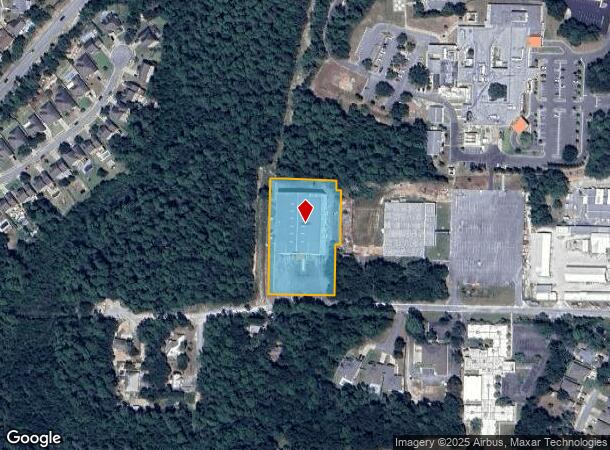
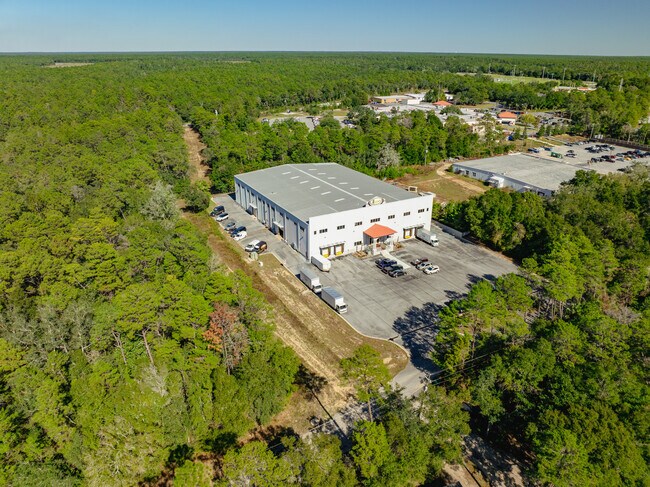
Property Record
200 Hart St, Niceville, FL 32578

NEARBY LISTINGS FOR SALE OR LEASE
Property Detail
200 Hart St
Crestview-Fort Walton Beach-Destin, FL
Niceville Hts Add
01-1S-23-0000-0001-0010
COM SE COR LOT 13 BLK 1 NICEVILLE HTS ADD N20 FT TO BEG W897.56 FT N388.25 FT E897.56 FT S388.25 FT TO BEG 903-821 EX FROM POB N87 DEG W 673.02FT N2 DEG E 170.24FT S87 DEG E 16FT N2 DEG E 184FT N87 DEG W 16FT N2 DEG E 34FT TO S LINE TWIN CITIES PCL S
Officebuilding
Okaloosa
X
Florida
12091C0390J
13
2025
2.06 AC
2025
Fort Walton Beach
021200
Other Market Areas
48,082 SF
DEMOGRAPHICS near 200 Hart St
1 mile
3 mile
5 mile
2024 Total Population
2,016
17,344
27,407
2029 Population
2,127
18,043
28,535
Pop Growth 2024-2029
+ 5.51%
+ 4.03%
+ 4.12%
Average Age
34
40
40
2024 Total Households
834
7,030
10,632
HH Growth 2024-2029
+ 5.40%
+ 3.97%
+ 4.03%
Median Household Inc
$85,558
$76,326
$87,233
Avg Household Size
2.40
2.40
2.50
2024 Avg HH Vehicles
2.00
2.00
2.00
Median Home Value
$301,603
$308,395
$347,727
Median Year Built
1984
1983
1986
Nearby Places
Map Layers
Map Styles
 Street
 Aerial
Transit
 Traffic
 Biking
Places
Listings with unknown addresses are not visible on the map
- Restaurants
- Banks
- Shops
- Fitness
- Groceries
PUBLIC TRANSPORTATION
AIRPORT
Eglin AFB/Destin-Ft Walton Beach
Drive
Walk
Distance
Eglin AFB/Destin-Ft Walton Beach
25 min
5.6 mi
Freight Ports
Port of Panama City
Drive
Walk
Distance
Port of Panama City
95 min
62.7 mi
SALE & LEASE HISTORY
LISTING DATE
SALE/LEASE

Sep 23, 2016
For Sale
Nov 17, 2016
For Lease
Dec 03, 2024
For Sale
Aug 02, 2025
For Lease
Nearby Properties
Address
Land Use
TOTAL SIZE
Lot Size
Zoning
Address
Land Use
TOTAL SIZE
Lot Size
Zoning
480 AC
Address
Land Use
TOTAL SIZE
Lot Size
Zoning
817,501 SF
121.04 AC
Address
Land Use
TOTAL SIZE
Lot Size
Zoning
263,492 SF
29.88 AC
Address
Land Use
TOTAL SIZE
Lot Size
Zoning
138,251 SF
11.32 AC
Address
Land Use
TOTAL SIZE
Lot Size
Zoning
10,401 SF
7.20 AC
Address
Land Use
TOTAL SIZE
Lot Size
Zoning
49,417 SF
3.19 AC
Address
Land Use
TOTAL SIZE
Lot Size
Zoning
75,002 SF
4.42 AC
Address
Land Use
TOTAL SIZE
Lot Size
Zoning
101,695 SF
15.11 AC
Address
Land Use
TOTAL SIZE
Lot Size
Zoning
0.85 AC
Address
Land Use
TOTAL SIZE
Lot Size
Zoning
28,763 SF
0.23 AC
Address
Land Use
TOTAL SIZE
Lot Size
Zoning
165,059 SF
17.62 AC
Address
Land Use
TOTAL SIZE
Lot Size
Zoning
33,575 SF
1.67 AC
Address
Land Use
TOTAL SIZE
Lot Size
Zoning
126,169 SF
8.90 AC
Address
Land Use
TOTAL SIZE
Lot Size
Zoning
129,846 SF
19.65 AC
Address
Land Use
TOTAL SIZE
Lot Size
Zoning
3.90 AC
Address
Land Use
TOTAL SIZE
Lot Size
Zoning
107,789 SF
10.47 AC
Address
Land Use
TOTAL SIZE
Lot Size
Zoning
54,627 SF
2.05 AC
Address
Land Use
TOTAL SIZE
Lot Size
Zoning
27,450 SF
0.85 AC
Address
Land Use
TOTAL SIZE
Lot Size
Zoning
101,110 SF
20.64 AC
Address
Land Use
TOTAL SIZE
Lot Size
Zoning
83,644 SF
1.39 AC
Address
Land Use
TOTAL SIZE
Lot Size
Zoning
40,261 SF
6.21 AC
Address
Land Use
TOTAL SIZE
Lot Size
Zoning
84,848 SF
41.85 AC
Address
Land Use
TOTAL SIZE
Lot Size
Zoning
30,953 SF
1.46 AC
Address
Land Use
TOTAL SIZE
Lot Size
Zoning
7.72 AC
Address
Land Use
TOTAL SIZE
Lot Size
Zoning
82,203 SF
7.14 AC
Address
Land Use
TOTAL SIZE
Lot Size
Zoning
43,484 SF
4.93 AC
Address
Land Use
TOTAL SIZE
Lot Size
Zoning
88,750 SF
9.95 AC
Address
Land Use
TOTAL SIZE
Lot Size
Zoning
43,920 SF
9.08 AC
Address
Land Use
TOTAL SIZE
Lot Size
Zoning
79,160 SF
8.51 AC
Address
Land Use
TOTAL SIZE
Lot Size
Zoning
53,693 SF
7.68 AC
The World's #1 Commercial Real Estate Marketplace
Connect with us
© 2026 CoStar Group
The information above has been obtained from sources believed reliable. While we do not doubt its accuracy we have not verified it and make no guarantee, warranty or representation about it. It is your responsibility to independently confirm its accuracy and completeness. Any projections, opinions, assumptions, or estimates used are for example only and do not represent the current or future performance of the property. The value of this transaction to you depends on tax and other factors which should be evaluated by your tax, financial, and legal advisors. You and your advisors should conduct a careful, independent investigation of the property to determine to your satisfaction the suitability of the property for your needs.