Property Record
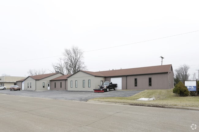
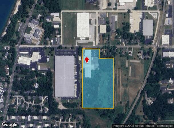
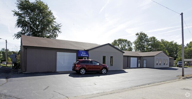
200 Hawthorne Ave, Saint Joseph, MI 49085
NEARBY LISTINGS FOR SALE OR LEASE
Property Detail
200 Hawthorne Ave
Distributionwarehouseregional
COM 641.19'E OF N1/4 PST SEC 3 T5S R19W TH S 1287.16' TH E 632.28' TH N 1018.16' TH W 293'TH N 269'TH W TO POB EXC N 66'FOR HAWTHORNE AVE
X
Berrien
26021C0084D
Michigan
2024
16 AC
2025
Other Market Areas
001300
Niles-Benton Harbor, MI
73,514 SF
11-76-0103-0007-00-4
DEMOGRAPHICS near 200 Hawthorne Ave
1 Mile
3 Mile
5 Mile
2024 Total Population
2,866
23,977
51,049
2029 Population
2,783
23,377
50,255
Pop Growth 2024-2029
(2.90%)
(2.50%)
(1.56%)
Average Age
43
43
41
2024 Total Households
1,405
10,798
21,256
HH Growth 2024-2029
(3.06%)
(2.65%)
(1.82%)
Median Household Inc
$64,332
$73,944
$59,124
Avg Household Size
2.00
2.20
2.30
2024 Avg HH Vehicles
2.00
2.00
2.00
Median Home Value
$221,594
$219,276
$221,545
Median Year Built
1969
1963
1965
Nearby Places
Map Layers
Map Styles
 Street
 Aerial
- Restaurants
- Banks
- Shops
- Fitness
- Groceries
PUBLIC TRANSPORTATION
COMMUTER RAIL
St. Joseph-Benton Harbor Amtrak Station (Pere Marquette - Amtrak)
DRIVE
WALK
Distance
St. Joseph-Benton Harbor Amtrak Station (Pere Marquette - Amtrak)
8 min
3.8 mi
AIRPORT
South Bend International
DRIVE
WALK
Distance
South Bend International
53 min
34.2 mi
Freight Ports
Port Milwaukee
DRIVE
WALK
Distance
Port Milwaukee
216 min
178.4 mi
Nearby Properties
Address
Land Use
TOTAL SIZE
Lot Size
Zoning
Address
Land Use
TOTAL SIZE
Lot Size
Zoning
Address
Land Use
TOTAL SIZE
Lot Size
Zoning
125,408 SF
4.66 AC
R-3
Address
Land Use
TOTAL SIZE
Lot Size
Zoning
87,978 SF
4.36 AC
R2 MDR
Address
Land Use
TOTAL SIZE
Lot Size
Zoning
73,680 SF
CO-A
Address
Land Use
TOTAL SIZE
Lot Size
Zoning
30,889 SF
2.83 AC
CO-A
Address
Land Use
TOTAL SIZE
Lot Size
Zoning
53,504 SF
Address
Land Use
TOTAL SIZE
Lot Size
Zoning
69,750 SF
0.47 AC
D
Address
Land Use
TOTAL SIZE
Lot Size
Zoning
42,610 SF
5.30 AC
C4 HEAVY
Address
Land Use
TOTAL SIZE
Lot Size
Zoning
330,000 SF
20.56 AC
I1
Address
Land Use
TOTAL SIZE
Lot Size
Zoning
28,312 SF
4.30 AC
C
Address
Land Use
TOTAL SIZE
Lot Size
Zoning
93,032 SF
0.51 AC
D
Address
Land Use
TOTAL SIZE
Lot Size
Zoning
45,270 SF
10.30 AC
C1 GEN COM
Address
Land Use
TOTAL SIZE
Lot Size
Zoning
82,567 SF
1.74 AC
D
Address
Land Use
TOTAL SIZE
Lot Size
Zoning
150,421 SF
10.30 AC
HD
Address
Land Use
TOTAL SIZE
Lot Size
Zoning
90,000 SF
7.62 AC
W
Address
Land Use
TOTAL SIZE
Lot Size
Zoning
519,203 SF
25.57 AC
C
Address
Land Use
TOTAL SIZE
Lot Size
Zoning
25,080 SF
I-1
Address
Land Use
TOTAL SIZE
Lot Size
Zoning
55,753 SF
6 AC
DISTRICT D
Address
Land Use
TOTAL SIZE
Lot Size
Zoning
403,396 SF
37.17 AC
HI
Address
Land Use
TOTAL SIZE
Lot Size
Zoning
54,750 SF
5.87 AC
CMU
Address
Land Use
TOTAL SIZE
Lot Size
Zoning
89,420 SF
7.89 AC
R3 - SINGL
Address
Land Use
TOTAL SIZE
Lot Size
Zoning
39,473 SF
2.90 AC
CO-A
Address
Land Use
TOTAL SIZE
Lot Size
Zoning
60,252 SF
3.17 AC
C
Address
Land Use
TOTAL SIZE
Lot Size
Zoning
Address
Land Use
TOTAL SIZE
Lot Size
Zoning
29,032 SF
4.62 AC
C1 GEN COM
Address
Land Use
TOTAL SIZE
Lot Size
Zoning
49,162 SF
3.04 AC
HC
Address
Land Use
TOTAL SIZE
Lot Size
Zoning
67,200 SF
3.90 AC
R-3
Address
Land Use
TOTAL SIZE
Lot Size
Zoning
0.99 AC
SELECTZONI
Address
Land Use
TOTAL SIZE
Lot Size
Zoning
29,655 SF
0.20 AC
D
Address
Land Use
TOTAL SIZE
Lot Size
Zoning
63,134 SF
4.90 AC
B2 - RET/S
The World's #1 Commercial Real Estate Marketplace
Connect with us
© 2025 CoStar Group
The information above has been obtained from sources believed reliable. While we do not doubt its accuracy we have not verified it and make no guarantee, warranty or representation about it. It is your responsibility to independently confirm its accuracy and completeness. Any projections, opinions, assumptions, or estimates used are for example only and do not represent the current or future performance of the property. The value of this transaction to you depends on tax and other factors which should be evaluated by your tax, financial, and legal advisors. You and your advisors should conduct a careful, independent investigation of the property to determine to your satisfaction the suitability of the property for your needs.