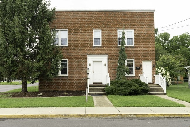
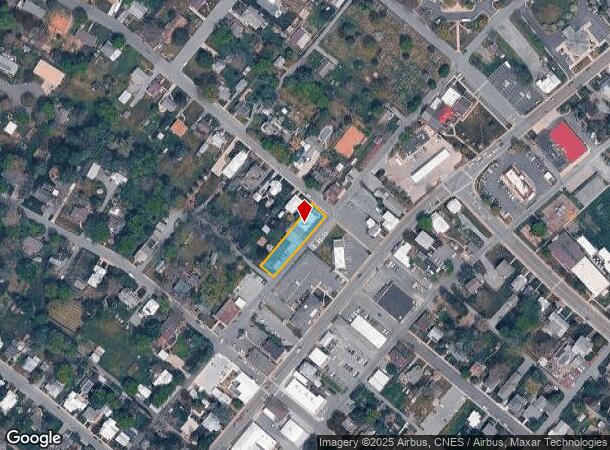
Property Record
202 High St, Bridgewater, VA 22812
NEARBY LISTINGS FOR SALE OR LEASE
Property Detail
202 High St
122A3-A-L114
High St
Commercialnec
200 HIGH ST LOT
X
Rockingham
51165C0388E
Virginia
2025
0.34 AC
2025
Staunton & Harrisonburg
011500
Other Market Areas
7,976 SF
Harrisonburg, VA
DEMOGRAPHICS near 202 High St
1 Mile
3 Mile
5 Mile
2024 Total Population
5,543
10,919
17,084
2029 Population
5,766
11,321
17,632
Pop Growth 2024-2029
+ 4.02%
+ 3.68%
+ 3.21%
Average Age
39
40
40
2024 Total Households
1,738
3,741
5,929
HH Growth 2024-2029
+ 4.37%
+ 3.85%
+ 3.26%
Median Household Inc
$71,695
$74,556
$73,008
Avg Household Size
2.30
2.40
2.50
2024 Avg HH Vehicles
2.00
2.00
2.00
Median Home Value
$302,740
$306,988
$299,675
Median Year Built
1978
1981
1984
Nearby Places
Map Layers
Map Styles
 Street
 Aerial
- Restaurants
- Banks
- Shops
- Fitness
- Groceries
SALE & LEASE HISTORY
LISTING DATE
SALE/LEASE

Sep 01, 2018
For Sale
Nearby Properties
Address
Land Use
TOTAL SIZE
Lot Size
Zoning
Address
Land Use
TOTAL SIZE
Lot Size
Zoning
25,038 SF
56.59 AC
R1
Address
Land Use
TOTAL SIZE
Lot Size
Zoning
57.92 AC
I1
Address
Land Use
TOTAL SIZE
Lot Size
Zoning
260,792 SF
27.98 AC
P1
Address
Land Use
TOTAL SIZE
Lot Size
Zoning
4,841 SF
7.07 AC
R3
Address
Land Use
TOTAL SIZE
Lot Size
Zoning
7,463 SF
74.63 AC
I1
Address
Land Use
TOTAL SIZE
Lot Size
Zoning
16.52 AC
TOWN
Address
Land Use
TOTAL SIZE
Lot Size
Zoning
295,543 SF
33.23 AC
I1
Address
Land Use
TOTAL SIZE
Lot Size
Zoning
21.42 AC
I1
Address
Land Use
TOTAL SIZE
Lot Size
Zoning
4.82 AC
B1
Address
Land Use
TOTAL SIZE
Lot Size
Zoning
74,032 SF
20.64 AC
R3
Address
Land Use
TOTAL SIZE
Lot Size
Zoning
36,612 SF
12.78 AC
R3
Address
Land Use
TOTAL SIZE
Lot Size
Zoning
6,000 SF
10 AC
I1
Address
Land Use
TOTAL SIZE
Lot Size
Zoning
28,451 SF
0.20 AC
R3
Address
Land Use
TOTAL SIZE
Lot Size
Zoning
3.69 AC
M1
Address
Land Use
TOTAL SIZE
Lot Size
Zoning
53,524 SF
4.16 AC
R1
Address
Land Use
TOTAL SIZE
Lot Size
Zoning
16,300 SF
10.68 AC
A2
Address
Land Use
TOTAL SIZE
Lot Size
Zoning
49,648 SF
6 AC
B1
Address
Land Use
TOTAL SIZE
Lot Size
Zoning
21,920 SF
6.40 AC
A2
Address
Land Use
TOTAL SIZE
Lot Size
Zoning
23,071 SF
8.19 AC
B2
Address
Land Use
TOTAL SIZE
Lot Size
Zoning
20,160 SF
15.73 AC
P1
Address
Land Use
TOTAL SIZE
Lot Size
Zoning
17,545 SF
2.33 AC
R1
Address
Land Use
TOTAL SIZE
Lot Size
Zoning
23,080 SF
0.70 AC
R1
Address
Land Use
TOTAL SIZE
Lot Size
Zoning
17,945 SF
6.99 AC
I1
Address
Land Use
TOTAL SIZE
Lot Size
Zoning
22,353 SF
7.91 AC
I1
Address
Land Use
TOTAL SIZE
Lot Size
Zoning
90,594 SF
6.07 AC
M1
Address
Land Use
TOTAL SIZE
Lot Size
Zoning
6,311 SF
1.83 AC
B1
Address
Land Use
TOTAL SIZE
Lot Size
Zoning
74,780 SF
5.82 AC
I1
Address
Land Use
TOTAL SIZE
Lot Size
Zoning
56,761 SF
6.96 AC
A2
Address
Land Use
TOTAL SIZE
Lot Size
Zoning
54,600 SF
3.61 AC
I1
Address
Land Use
TOTAL SIZE
Lot Size
Zoning
16,529 SF
34.40 AC
P1
The World's #1 Commercial Real Estate Marketplace
Connect with us
© 2025 CoStar Group
The information above has been obtained from sources believed reliable. While we do not doubt its accuracy we have not verified it and make no guarantee, warranty or representation about it. It is your responsibility to independently confirm its accuracy and completeness. Any projections, opinions, assumptions, or estimates used are for example only and do not represent the current or future performance of the property. The value of this transaction to you depends on tax and other factors which should be evaluated by your tax, financial, and legal advisors. You and your advisors should conduct a careful, independent investigation of the property to determine to your satisfaction the suitability of the property for your needs.