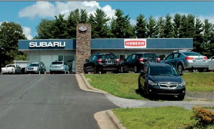
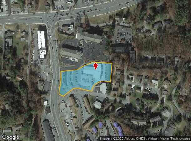
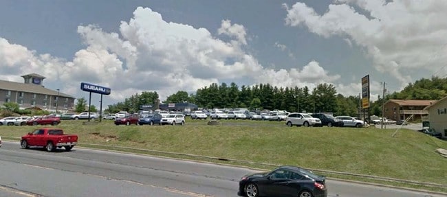
Property Record
229 Highway 105 Ext, Boone, NC 28607
NEARBY LISTINGS FOR SALE OR LEASE
Property Detail
229 Highway 105 Ext
2910-27-8467-000
Division For John D Cook Johnson Cook In
Commercialofficeresidentialmixeduse
T-1 P018/248
X
Watauga
3710291000J
North Carolina
2024
2.56 AC
2025
Hickory/Morganton
920601
Other Market Areas
40,744 SF
Boone, NC
DEMOGRAPHICS near 229 Highway 105 Ext
1 mile
3 mile
5 mile
2024 Total Population
10,570
24,467
33,008
2029 Population
10,567
24,388
33,044
Pop Growth 2024-2029
(0.03%)
(0.32%)
+ 0.11%
Average Age
26
30
32
2024 Total Households
2,747
8,005
11,663
HH Growth 2024-2029
(1.38%)
(1.19%)
(0.38%)
Median Household Inc
$26,325
$31,613
$38,863
Avg Household Size
2.00
2.10
2.20
2024 Avg HH Vehicles
2.00
2.00
2.00
Median Home Value
$309,268
$299,840
$298,109
Median Year Built
1983
1985
1986
Nearby Places
Map Layers
Map Styles
 Street
 Aerial
Transit
 Traffic
 Biking
Places
Listings with unknown addresses are not visible on the map
- Restaurants
- Banks
- Shops
- Fitness
- Groceries
SALE & LEASE HISTORY
LISTING DATE
SALE/LEASE

Sep 25, 2016
For Lease
Sep 24, 2016
For Sale
Nearby Properties
Address
Land Use
TOTAL SIZE
Lot Size
Zoning
Address
Land Use
TOTAL SIZE
Lot Size
Zoning
79,170 SF
8.98 AC
BOOI
Address
Land Use
TOTAL SIZE
Lot Size
Zoning
78,360 SF
13.20 AC
BOOI
Address
Land Use
TOTAL SIZE
Lot Size
Zoning
49,971 SF
7.88 AC
BOB3
Address
Land Use
TOTAL SIZE
Lot Size
Zoning
96,030 SF
4.73 AC
BOB3
Address
Land Use
TOTAL SIZE
Lot Size
Zoning
2,960 SF
2.75 AC
BOB1
Address
Land Use
TOTAL SIZE
Lot Size
Zoning
88 AC
BOMZ
Address
Land Use
TOTAL SIZE
Lot Size
Zoning
35,080 SF
5.28 AC
BOU1
Address
Land Use
TOTAL SIZE
Lot Size
Zoning
3,024 SF
47.37 AC
BOMZ
Address
Land Use
TOTAL SIZE
Lot Size
Zoning
3,241 SF
9.60 AC
BOU1
Address
Land Use
TOTAL SIZE
Lot Size
Zoning
2,580 SF
30.87 AC
BOR3
Address
Land Use
TOTAL SIZE
Lot Size
Zoning
19,032 SF
18.78 AC
BOMZ
Address
Land Use
TOTAL SIZE
Lot Size
Zoning
3,414 SF
11.52 AC
BOB3
Address
Land Use
TOTAL SIZE
Lot Size
Zoning
96,732 SF
9.12 AC
BOOI
Address
Land Use
TOTAL SIZE
Lot Size
Zoning
19,348 SF
0.31 AC
BOB1
Address
Land Use
TOTAL SIZE
Lot Size
Zoning
51,084 SF
8.65 AC
BOMZ
Address
Land Use
TOTAL SIZE
Lot Size
Zoning
16,320 SF
4.96 AC
BOU1
Address
Land Use
TOTAL SIZE
Lot Size
Zoning
47,872 SF
25.06 AC
BOU1
Address
Land Use
TOTAL SIZE
Lot Size
Zoning
79,392 SF
5.48 AC
BOB3
Address
Land Use
TOTAL SIZE
Lot Size
Zoning
31,856 SF
8.76 AC
BOU1
Address
Land Use
TOTAL SIZE
Lot Size
Zoning
2,870 SF
11.75 AC
BOMZ
Address
Land Use
TOTAL SIZE
Lot Size
Zoning
152,010 SF
5.72 AC
BOU1
Address
Land Use
TOTAL SIZE
Lot Size
Zoning
23,450 SF
1.14 AC
BOB2
Address
Land Use
TOTAL SIZE
Lot Size
Zoning
31,703 SF
2.85 AC
BOB3
Address
Land Use
TOTAL SIZE
Lot Size
Zoning
9,072 SF
4.83 AC
BOMZ
Address
Land Use
TOTAL SIZE
Lot Size
Zoning
1,200 SF
15.50 AC
BOMZ
Address
Land Use
TOTAL SIZE
Lot Size
Zoning
32,083 SF
5 AC
BOU1
Address
Land Use
TOTAL SIZE
Lot Size
Zoning
8,052 SF
44.52 AC
E2OI
The World's #1 Commercial Real Estate Marketplace
Connect with us
© 2026 CoStar Group
The information above has been obtained from sources believed reliable. While we do not doubt its accuracy we have not verified it and make no guarantee, warranty or representation about it. It is your responsibility to independently confirm its accuracy and completeness. Any projections, opinions, assumptions, or estimates used are for example only and do not represent the current or future performance of the property. The value of this transaction to you depends on tax and other factors which should be evaluated by your tax, financial, and legal advisors. You and your advisors should conduct a careful, independent investigation of the property to determine to your satisfaction the suitability of the property for your needs.