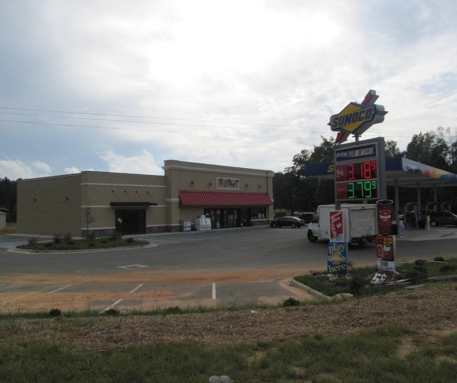
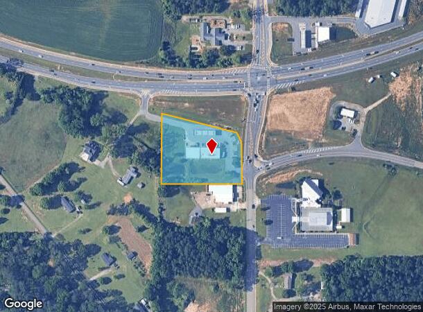
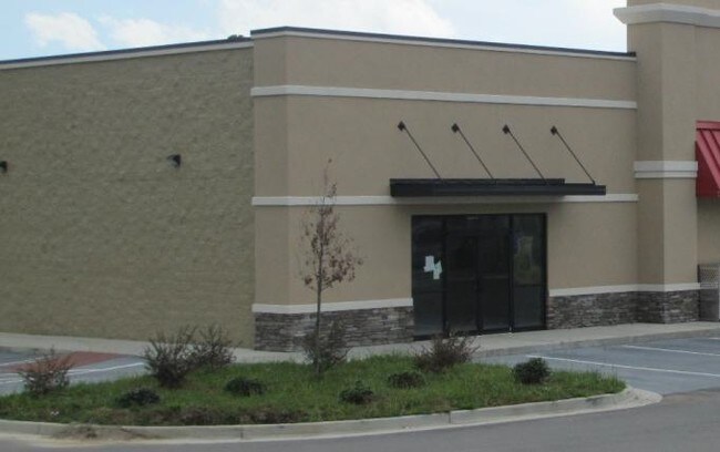
Property Record
200 Highway 96, Bonaire, GA 31005
NEARBY LISTINGS FOR SALE OR LEASE
Property Detail
200 Highway 96
001250104000
Hwy 96 Rus Mo 50
Conveniencestore
TRACT A 2.50 ACRES LL12 11TH LD
X
Houston
13289C0200B
Georgia
2024
2.50 AC
2024
Perry/Warner Robins
021115
Other Market Areas
4,656 SF
Warner Robins, GA
DEMOGRAPHICS near 200 Highway 96
1 Mile
3 Mile
5 Mile
2024 Total Population
3,376
26,001
76,513
2029 Population
3,754
28,609
83,997
Pop Growth 2024-2029
+ 11.20%
+ 10.03%
+ 9.78%
Average Age
36
37
37
2024 Total Households
1,167
9,439
28,308
HH Growth 2024-2029
+ 10.88%
+ 9.72%
+ 9.57%
Median Household Inc
$114,644
$96,204
$85,144
Avg Household Size
2.80
2.70
2.60
2024 Avg HH Vehicles
3.00
2.00
2.00
Median Home Value
$236,416
$216,319
$182,259
Median Year Built
2006
1999
1995
Nearby Places
Map Layers
Map Styles
 Street
 Aerial
- Restaurants
- Banks
- Shops
- Fitness
- Groceries
SALE & LEASE HISTORY
LISTING DATE
SALE/LEASE

Mar 10, 2017
For Lease
Nearby Properties
Address
Land Use
TOTAL SIZE
Lot Size
Zoning
Address
Land Use
TOTAL SIZE
Lot Size
Zoning
180,000 SF
146.60 AC
RAG
Address
Land Use
TOTAL SIZE
Lot Size
Zoning
100,320 SF
26.91 AC
C2
Address
Land Use
TOTAL SIZE
Lot Size
Zoning
842,179 SF
101.75 AC
M2
Address
Land Use
TOTAL SIZE
Lot Size
Zoning
139,756 SF
34.14 AC
R1
Address
Land Use
TOTAL SIZE
Lot Size
Zoning
134,400 SF
22.43 AC
R1
Address
Land Use
TOTAL SIZE
Lot Size
Zoning
106,055 SF
35.17 AC
R1
Address
Land Use
TOTAL SIZE
Lot Size
Zoning
210,408 SF
47.18 AC
C2
Address
Land Use
TOTAL SIZE
Lot Size
Zoning
19,200 SF
14.70 AC
R4
Address
Land Use
TOTAL SIZE
Lot Size
Zoning
17,832 SF
13.60 AC
R4
Address
Land Use
TOTAL SIZE
Lot Size
Zoning
100,000 SF
12.12 AC
RAG
Address
Land Use
TOTAL SIZE
Lot Size
Zoning
48,462 SF
5.54 AC
C2
Address
Land Use
TOTAL SIZE
Lot Size
Zoning
5,412 SF
4.98 AC
R4
Address
Land Use
TOTAL SIZE
Lot Size
Zoning
102,400 SF
28.22 AC
M2
Address
Land Use
TOTAL SIZE
Lot Size
Zoning
40,050 SF
7.63 AC
M1
Address
Land Use
TOTAL SIZE
Lot Size
Zoning
2,882 SF
116.81 AC
C2 R1 RAG
Address
Land Use
TOTAL SIZE
Lot Size
Zoning
19,200 SF
8.51 AC
R1
Address
Land Use
TOTAL SIZE
Lot Size
Zoning
26,928 SF
5.74 AC
R4
Address
Land Use
TOTAL SIZE
Lot Size
Zoning
29,950 SF
4.97 AC
R1
Address
Land Use
TOTAL SIZE
Lot Size
Zoning
34,337 SF
3.89 AC
M1
Address
Land Use
TOTAL SIZE
Lot Size
Zoning
12,791 SF
15.66 AC
C1
Address
Land Use
TOTAL SIZE
Lot Size
Zoning
4,830 SF
3.83 AC
M1
Address
Land Use
TOTAL SIZE
Lot Size
Zoning
4,538 SF
50.06 AC
R2 R3 R4
Address
Land Use
TOTAL SIZE
Lot Size
Zoning
14,400 SF
81.92 AC
M2
Address
Land Use
TOTAL SIZE
Lot Size
Zoning
4,469 SF
159.20 AC
M2
Address
Land Use
TOTAL SIZE
Lot Size
Zoning
45,749 SF
4.95 AC
C2
Address
Land Use
TOTAL SIZE
Lot Size
Zoning
54,142 SF
19.17 AC
M2
Address
Land Use
TOTAL SIZE
Lot Size
Zoning
18,633 SF
6.54 AC
PUD
Address
Land Use
TOTAL SIZE
Lot Size
Zoning
19,556 SF
7.03 AC
C2
Address
Land Use
TOTAL SIZE
Lot Size
Zoning
2,400 SF
4.15 AC
PUD
Address
Land Use
TOTAL SIZE
Lot Size
Zoning
14.42 AC
C2
The World's #1 Commercial Real Estate Marketplace
Connect with us
© 2026 CoStar Group
The information above has been obtained from sources believed reliable. While we do not doubt its accuracy we have not verified it and make no guarantee, warranty or representation about it. It is your responsibility to independently confirm its accuracy and completeness. Any projections, opinions, assumptions, or estimates used are for example only and do not represent the current or future performance of the property. The value of this transaction to you depends on tax and other factors which should be evaluated by your tax, financial, and legal advisors. You and your advisors should conduct a careful, independent investigation of the property to determine to your satisfaction the suitability of the property for your needs.