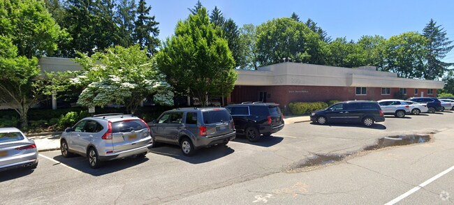
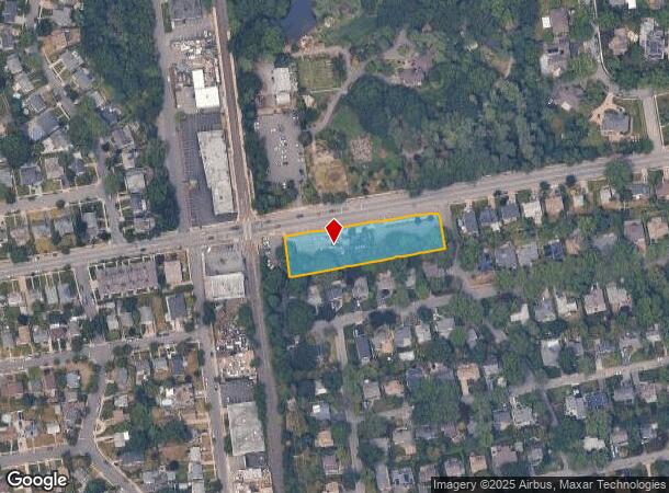
Property Record
200 I U Willets Rd, Albertson, NY 11507
NEARBY LISTINGS FOR SALE OR LEASE
Property Detail
200 I U Willets Rd
Nassau County-Suffolk County, NY
Albertson Downs
2289-09-116-00-0001-0
1-21
Officebuilding
Nassau
X
New York
36059C0119G
1
2025
1.01 AC
2025
Central Nassau
302501
Long Island (New York)
18,814 SF
DEMOGRAPHICS near 200 I U Willets Rd
1 Mile
3 Mile
5 Mile
2024 Total Population
17,224
120,157
390,111
2029 Population
16,948
118,565
381,877
Pop Growth 2024-2029
(1.60%)
(1.32%)
(2.11%)
Average Age
42
43
42
2024 Total Households
5,705
41,429
128,417
HH Growth 2024-2029
(1.77%)
(1.38%)
(2.25%)
Median Household Inc
$145,229
$146,186
$125,261
Avg Household Size
3.00
2.80
2.90
2024 Avg HH Vehicles
2.00
2.00
2.00
Median Home Value
$793,739
$815,146
$764,932
Median Year Built
1952
1954
1954
Nearby Places
- Restaurants
- Banks
- Shops
- Fitness
- Groceries
PUBLIC TRANSPORTATION
COMMUTER RAIL
Albertson Station (Oyster Bay Branch - Long Island Rail Road)
DRIVE
WALK
Distance
Albertson Station (Oyster Bay Branch - Long Island Rail Road)
0 min
3 min
0.1 mi
East Williston Station (Oyster Bay Branch - Long Island Rail Road)
DRIVE
WALK
Distance
East Williston Station (Oyster Bay Branch - Long Island Rail Road)
3 min
1.5 mi
AIRPORT
LaGuardia
DRIVE
WALK
Distance
LaGuardia
25 min
15.4 mi
John F Kennedy International
DRIVE
WALK
Distance
John F Kennedy International
27 min
17.9 mi
Westchester County
DRIVE
WALK
Distance
Westchester County
55 min
35.8 mi
Freight Ports
NY - Red Hook Container Terminal
DRIVE
WALK
Distance
NY - Red Hook Container Terminal
36 min
23.5 mi
Nearby Properties
Address
Land Use
TOTAL SIZE
Lot Size
Zoning
Address
Land Use
TOTAL SIZE
Lot Size
Zoning
5,322,666 SF
86.10 AC
Address
Land Use
TOTAL SIZE
Lot Size
Zoning
556,575 SF
11.46 AC
Address
Land Use
TOTAL SIZE
Lot Size
Zoning
375,331 SF
14.83 AC
Address
Land Use
TOTAL SIZE
Lot Size
Zoning
352,730 SF
41.04 AC
Address
Land Use
TOTAL SIZE
Lot Size
Zoning
29,224 SF
1.33 AC
Address
Land Use
TOTAL SIZE
Lot Size
Zoning
152,926 SF
30 AC
Address
Land Use
TOTAL SIZE
Lot Size
Zoning
277,200 SF
21.03 AC
Address
Land Use
TOTAL SIZE
Lot Size
Zoning
111,756 SF
21.24 AC
Address
Land Use
TOTAL SIZE
Lot Size
Zoning
63,600 SF
2 AC
Address
Land Use
TOTAL SIZE
Lot Size
Zoning
182,129 SF
1.51 AC
Address
Land Use
TOTAL SIZE
Lot Size
Zoning
152,783 SF
51.20 AC
Address
Land Use
TOTAL SIZE
Lot Size
Zoning
158,725 SF
24.46 AC
Address
Land Use
TOTAL SIZE
Lot Size
Zoning
399,955 SF
13.63 AC
Address
Land Use
TOTAL SIZE
Lot Size
Zoning
401,583 SF
17.93 AC
Address
Land Use
TOTAL SIZE
Lot Size
Zoning
50,252 SF
143.04 AC
Address
Land Use
TOTAL SIZE
Lot Size
Zoning
186,050 SF
8.64 AC
Address
Land Use
TOTAL SIZE
Lot Size
Zoning
252,032 SF
4.72 AC
Address
Land Use
TOTAL SIZE
Lot Size
Zoning
147,148 SF
8.39 AC
Address
Land Use
TOTAL SIZE
Lot Size
Zoning
49,950 SF
51.02 AC
Address
Land Use
TOTAL SIZE
Lot Size
Zoning
80,819 SF
6.90 AC
Address
Land Use
TOTAL SIZE
Lot Size
Zoning
31,828 SF
14.74 AC
Address
Land Use
TOTAL SIZE
Lot Size
Zoning
171,770 SF
5.95 AC
Address
Land Use
TOTAL SIZE
Lot Size
Zoning
84,966 SF
18.74 AC
Address
Land Use
TOTAL SIZE
Lot Size
Zoning
170,753 SF
26.64 AC
Address
Land Use
TOTAL SIZE
Lot Size
Zoning
179,365 SF
6.05 AC
Address
Land Use
TOTAL SIZE
Lot Size
Zoning
197,357 SF
32.05 AC
Address
Land Use
TOTAL SIZE
Lot Size
Zoning
2,520,272 SF
36.98 AC
Address
Land Use
TOTAL SIZE
Lot Size
Zoning
165,793 SF
18.61 AC
Address
Land Use
TOTAL SIZE
Lot Size
Zoning
154,268 SF
5.94 AC
Address
Land Use
TOTAL SIZE
Lot Size
Zoning
552,672 SF
8.72 AC
The World's #1 Commercial Real Estate Marketplace
Connect with us
© 2025 CoStar Group
The information above has been obtained from sources believed reliable. While we do not doubt its accuracy we have not verified it and make no guarantee, warranty or representation about it. It is your responsibility to independently confirm its accuracy and completeness. Any projections, opinions, assumptions, or estimates used are for example only and do not represent the current or future performance of the property. The value of this transaction to you depends on tax and other factors which should be evaluated by your tax, financial, and legal advisors. You and your advisors should conduct a careful, independent investigation of the property to determine to your satisfaction the suitability of the property for your needs.