Property Record
200 K-Flex Way, Youngsville, NC 27596
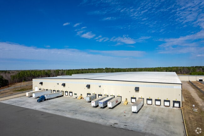

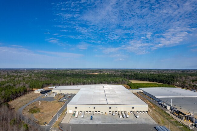

Property Detail
200 K-Flex Way
Warehouse
FRANKLIN
IND
North Carolina
B and X Area of moderate flood hazard, usually the area between the limits of the 100-year and 500-year floods.
30.25 AC
2025
Franklin County
2025
Raleigh/Durham
060502
Raleigh-Cary, NC
364,500 SF
042992
NEARBY LISTINGS FOR SALE OR LEASE
DEMOGRAPHICS near 200 K-Flex Way
1 mile
3 mile
5 mile
2025 Total Population
1,757
30,388
79,206
2030 Population
1,983
33,885
87,852
Pop Growth 2025-2030
+ 12.86%
+ 11.51%
+ 10.92%
Average Age
40
39
40
2025 Total Households
681
11,056
28,999
HH Growth 2025-2030
+ 13.51%
+ 11.97%
+ 11.33%
Median Household Inc
$98,586
$95,446
$106,765
Avg Household Size
2.50
2.70
2.70
2025 Avg HH Vehicles
3.00
2.00
2.00
Median Home Value
$422,388
$422,072
$448,371
Median Year Built
1998
2003
2007
Nearby Places
Map Layers
Map Styles
 Street
 Aerial
Layers
 Traffic
 Biking
Places
Listings with unknown addresses are not visible on the map
- Restaurants
- Banks
- Shops
- Fitness
- Groceries
PUBLIC TRANSPORTATION
AIRPORT
Raleigh-Durham International
Drive
Walk
Distance
Raleigh-Durham International
40 min
24.8 mi
Freight Ports
Virginia Port Authority - Richmond
Drive
Walk
Distance
Virginia Port Authority - Richmond
159 min
132.0 mi
Nearby Properties
Address
Land Use
TOTAL SIZE
Lot Size
Zoning
Address
Land Use
TOTAL SIZE
Lot Size
Zoning
442,480 SF
52.02 AC
GR3
Address
Land Use
TOTAL SIZE
Lot Size
Zoning
283,795 SF
31.33 AC
ICD
Address
Land Use
TOTAL SIZE
Lot Size
Zoning
159,584 SF
67.12 AC
FCO GB
Address
Land Use
TOTAL SIZE
Lot Size
Zoning
136,644 SF
4.38 AC
RMX
Address
Land Use
TOTAL SIZE
Lot Size
Zoning
143,060 SF
7.19 AC
RMX
Address
Land Use
TOTAL SIZE
Lot Size
Zoning
97,878 SF
26.85 AC
GR5
Address
Land Use
TOTAL SIZE
Lot Size
Zoning
216,580 SF
14.99 AC
FCO GB
Address
Land Use
TOTAL SIZE
Lot Size
Zoning
170,100 SF
15.41 AC
FCO GB
Address
Land Use
TOTAL SIZE
Lot Size
Zoning
102,946 SF
43.23 AC
FCO GB
Address
Land Use
TOTAL SIZE
Lot Size
Zoning
91,233 SF
11.04 AC
GR10
Address
Land Use
TOTAL SIZE
Lot Size
Zoning
103,310 SF
6.29 AC
RMX
Address
Land Use
TOTAL SIZE
Lot Size
Zoning
117,680 SF
11.99 AC
GR10
Address
Land Use
TOTAL SIZE
Lot Size
Zoning
160,525 SF
20.02 AC
IND
Address
Land Use
TOTAL SIZE
Lot Size
Zoning
58,211 SF
6.96 AC
NMX
Address
Land Use
TOTAL SIZE
Lot Size
Zoning
77,343 SF
14.12 AC
GR5
Address
Land Use
TOTAL SIZE
Lot Size
Zoning
117,037 SF
13.88 AC
GR10
Address
Land Use
TOTAL SIZE
Lot Size
Zoning
105,912 SF
8.44 AC
GR10
Address
Land Use
TOTAL SIZE
Lot Size
Zoning
92,980 SF
145.72 AC
RMX
Address
Land Use
TOTAL SIZE
Lot Size
Zoning
109,437 SF
12.01 AC
GR3
Address
Land Use
TOTAL SIZE
Lot Size
Zoning
81,604 SF
17.53 AC
CIVIC
Address
Land Use
TOTAL SIZE
Lot Size
Zoning
65,837 SF
30 AC
M U
Address
Land Use
TOTAL SIZE
Lot Size
Zoning
68,189 SF
8.46 AC
HB
Address
Land Use
TOTAL SIZE
Lot Size
Zoning
75,210 SF
1.78 AC
HB
Address
Land Use
TOTAL SIZE
Lot Size
Zoning
148,249 SF
8.45 AC
L I
Address
Land Use
TOTAL SIZE
Lot Size
Zoning
54,023 SF
1.14 AC
GR3
Address
Land Use
TOTAL SIZE
Lot Size
Zoning
28,756 SF
100.63 AC
FCO GB
Address
Land Use
TOTAL SIZE
Lot Size
Zoning
44,633 SF
2 AC
RA HC
Address
Land Use
TOTAL SIZE
Lot Size
Zoning
34,176 SF
12.93 AC
CU-1
Address
Land Use
TOTAL SIZE
Lot Size
Zoning
53,072 SF
20.91 AC
FCO GB
The World's #1 Commercial Real Estate Marketplace
Connect with us
© 2026 CoStar Group
The information above has been obtained from sources believed reliable. While we do not doubt its accuracy we have not verified it and make no guarantee, warranty or representation about it. It is your responsibility to independently confirm its accuracy and completeness. Any projections, opinions, assumptions, or estimates used are for example only and do not represent the current or future performance of the property. The value of this transaction to you depends on tax and other factors which should be evaluated by your tax, financial, and legal advisors. You and your advisors should conduct a careful, independent investigation of the property to determine to your satisfaction the suitability of the property for your needs.