Property Record
200 Kahelu Ave, Mililani, HI 96789


NEARBY LISTINGS FOR SALE OR LEASE
-
-
View all Mililani listings for sale on LoopNet.com
Property Detail
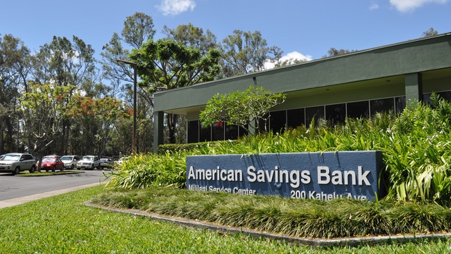
200 Kahelu Ave
Urban Honolulu, HI
Amer Sav Bank
1-9-5-046-002-0000
LOT 14855 5.001 AC MAP 909 LCAPP 1000 TOG/ESMT SUBJ/ESMT
Industrialgeneral
Honolulu
D
Hawaii
15003C0226F
14855
2024
5 AC
2025
Central Oahu
008926
Hawaii
30,000 SF
DEMOGRAPHICS near 200 Kahelu Ave
1 Mile
3 Mile
5 Mile
2024 Total Population
9,302
75,366
97,971
2029 Population
9,375
72,838
94,822
Pop Growth 2024-2029
+ 0.78%
(3.35%)
(3.21%)
Average Age
34
38
37
2024 Total Households
3,220
23,649
30,938
HH Growth 2024-2029
+ 0.53%
(3.99%)
(3.92%)
Median Household Inc
$95,214
$96,530
$93,181
Avg Household Size
2.70
3.00
3.00
2024 Avg HH Vehicles
2.00
2.00
2.00
Median Home Value
$630,479
$706,048
$698,947
Median Year Built
1999
1982
1984
Nearby Places
Map Layers
Map Styles
 Street
 Aerial
- Restaurants
- Banks
- Shops
- Fitness
- Groceries
PUBLIC TRANSPORTATION
AIRPORT
Daniel K Inouye International
DRIVE
WALK
Distance
Daniel K Inouye International
24 min
16.1 mi
Freight Ports
Honolulu Harbor, Oahu
DRIVE
WALK
Distance
Honolulu Harbor, Oahu
32 min
20.2 mi
SALE & LEASE HISTORY
LISTING DATE
SALE/LEASE

Jun 06, 2019
For Sale
Nearby Properties
Address
Land Use
TOTAL SIZE
Lot Size
Zoning
Address
Land Use
TOTAL SIZE
Lot Size
Zoning
196,140 SF
17.74 AC
B-2
Address
Land Use
TOTAL SIZE
Lot Size
Zoning
121,310 SF
10.97 AC
B-2
Address
Land Use
TOTAL SIZE
Lot Size
Zoning
129,731 SF
8.45 AC
B-2
Address
Land Use
TOTAL SIZE
Lot Size
Zoning
8.16 AC
I-2
Address
Land Use
TOTAL SIZE
Lot Size
Zoning
684.89 AC
F-1
Address
Land Use
TOTAL SIZE
Lot Size
Zoning
21,580 SF
4.77 AC
B-2
Address
Land Use
TOTAL SIZE
Lot Size
Zoning
132,900 SF
3.52 AC
IMX-1
Address
Land Use
TOTAL SIZE
Lot Size
Zoning
70,807 SF
4.31 AC
B-2
Address
Land Use
TOTAL SIZE
Lot Size
Zoning
7.51 AC
B-2
Address
Land Use
TOTAL SIZE
Lot Size
Zoning
56,029 SF
3.37 AC
IMX-1
Address
Land Use
TOTAL SIZE
Lot Size
Zoning
49,140 SF
1.33 AC
B-2
Address
Land Use
TOTAL SIZE
Lot Size
Zoning
39,600 SF
3.03 AC
B-2
Address
Land Use
TOTAL SIZE
Lot Size
Zoning
37,541 SF
4.21 AC
B-1
Address
Land Use
TOTAL SIZE
Lot Size
Zoning
106,550 SF
3.64 AC
IMX-1
Address
Land Use
TOTAL SIZE
Lot Size
Zoning
111,722 SF
2.97 AC
IMX-1
Address
Land Use
TOTAL SIZE
Lot Size
Zoning
3.65 AC
IMX-1
Address
Land Use
TOTAL SIZE
Lot Size
Zoning
263.30 AC
AG-1
Address
Land Use
TOTAL SIZE
Lot Size
Zoning
77,207 SF
3.64 AC
IMX-1
Address
Land Use
TOTAL SIZE
Lot Size
Zoning
71,141 SF
4.32 AC
IMX-1
Address
Land Use
TOTAL SIZE
Lot Size
Zoning
2,495 SF
2.30 AC
B-2
Address
Land Use
TOTAL SIZE
Lot Size
Zoning
24,292 SF
17.93 AC
AG-2
Address
Land Use
TOTAL SIZE
Lot Size
Zoning
42,886 SF
1.78 AC
B-2
Address
Land Use
TOTAL SIZE
Lot Size
Zoning
15,341 SF
4.50 AC
B-2
Address
Land Use
TOTAL SIZE
Lot Size
Zoning
42,886 SF
1.52 AC
B-2
Address
Land Use
TOTAL SIZE
Lot Size
Zoning
42,886 SF
1.72 AC
B-2
Address
Land Use
TOTAL SIZE
Lot Size
Zoning
52,005 SF
4 AC
IMX-1
Address
Land Use
TOTAL SIZE
Lot Size
Zoning
42,886 SF
1.32 AC
B-2
Address
Land Use
TOTAL SIZE
Lot Size
Zoning
67,524 SF
4 AC
IMX-1
Address
Land Use
TOTAL SIZE
Lot Size
Zoning
55,440 SF
3.22 AC
B-2
Address
Land Use
TOTAL SIZE
Lot Size
Zoning
186.16 AC
AG-1
The World's #1 Commercial Real Estate Marketplace
Connect with us
© 2026 CoStar Group
The information above has been obtained from sources believed reliable. While we do not doubt its accuracy we have not verified it and make no guarantee, warranty or representation about it. It is your responsibility to independently confirm its accuracy and completeness. Any projections, opinions, assumptions, or estimates used are for example only and do not represent the current or future performance of the property. The value of this transaction to you depends on tax and other factors which should be evaluated by your tax, financial, and legal advisors. You and your advisors should conduct a careful, independent investigation of the property to determine to your satisfaction the suitability of the property for your needs.