Property Record
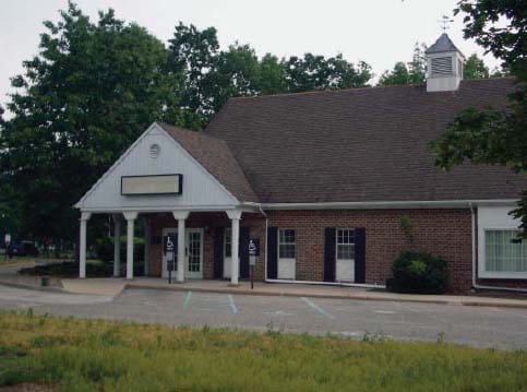
200 Lacey Rd, Whiting, NJ 08759


Property Detail
200 Lacey Rd
19-00109-0000-00017
1.12AC MEDICAL OFFICE
Commercialnec
Ocean
WTB1
New Jersey
B and X Area of moderate flood hazard, usually the area between the limits of the 100-year and 500-year floods.
17
2025
1.12 AC
2025
Ocean County
739100
Northern New Jersey
2,988 SF
Lakewood-New Brunswick, NJ
NEARBY LISTINGS FOR SALE OR LEASE
-
-
View all Whiting listings for sale on LoopNet.com
DEMOGRAPHICS near 200 Lacey Rd
1 mile
3 mile
5 mile
2025 Total Population
5,426
15,536
18,355
2030 Population
5,489
15,639
18,515
Pop Growth 2025-2030
+ 1.16%
+ 0.66%
+ 0.87%
Average Age
65
64
63
2025 Total Households
3,422
9,159
10,700
HH Growth 2025-2030
+ 0.35%
(0.23%)
+ 0.07%
Median Household Inc
$40,723
$43,486
$44,583
Avg Household Size
1.50
1.60
1.60
2025 Avg HH Vehicles
1.00
1.00
1.00
Median Home Value
$117,657
$127,226
$124,785
Median Year Built
1975
1976
1976
Nearby Places
Map Layers
Map Styles
 Street
 Aerial
Transit
 Traffic
 Biking
Places
Listings with unknown addresses are not visible on the map
- Restaurants
- Banks
- Shops
- Fitness
- Groceries
PUBLIC TRANSPORTATION
AIRPORT
Trenton Mercer
Drive
Walk
Distance
Trenton Mercer
59 min
38.8 mi
Atlantic City International
Drive
Walk
Distance
Atlantic City International
84 min
45.6 mi
Freight Ports
South Jersey Port
Drive
Walk
Distance
South Jersey Port
60 min
42.7 mi
Nearby Properties
Address
Land Use
TOTAL SIZE
Lot Size
Zoning
Address
Land Use
TOTAL SIZE
Lot Size
Zoning
1,638 SF
177.65 AC
WTRC
Address
Land Use
TOTAL SIZE
Lot Size
Zoning
179.01 AC
RC
Address
Land Use
TOTAL SIZE
Lot Size
Zoning
126.21 AC
RC
Address
Land Use
TOTAL SIZE
Lot Size
Zoning
64.16 AC
RC
Address
Land Use
TOTAL SIZE
Lot Size
Zoning
39.46 AC
WTRC
Address
Land Use
TOTAL SIZE
Lot Size
Zoning
278 SF
55.93 AC
WTRC
Address
Land Use
TOTAL SIZE
Lot Size
Zoning
63,330 SF
30.02 AC
WTRA
Address
Land Use
TOTAL SIZE
Lot Size
Zoning
50.82 AC
RC
Address
Land Use
TOTAL SIZE
Lot Size
Zoning
7,664 SF
192.40 AC
WTRA
Address
Land Use
TOTAL SIZE
Lot Size
Zoning
1,080 SF
326.01 AC
WT40
Address
Land Use
TOTAL SIZE
Lot Size
Zoning
9,006 SF
97.13 AC
WTRC
Address
Land Use
TOTAL SIZE
Lot Size
Zoning
10,864 SF
73.62 AC
WTRC
Address
Land Use
TOTAL SIZE
Lot Size
Zoning
66.19 AC
RC
Address
Land Use
TOTAL SIZE
Lot Size
Zoning
54.09 AC
WTRC
Address
Land Use
TOTAL SIZE
Lot Size
Zoning
19,380 SF
53.81 AC
RC
Address
Land Use
TOTAL SIZE
Lot Size
Zoning
13,499 SF
51.86 AC
WTRC
Address
Land Use
TOTAL SIZE
Lot Size
Zoning
2,295 SF
40.60 AC
WTRC
Address
Land Use
TOTAL SIZE
Lot Size
Zoning
163 SF
18.96 AC
WTRA
Address
Land Use
TOTAL SIZE
Lot Size
Zoning
32,650 SF
8.42 AC
WTRC
Address
Land Use
TOTAL SIZE
Lot Size
Zoning
92,090 SF
17.22 AC
WTHD
Address
Land Use
TOTAL SIZE
Lot Size
Zoning
3,619.50 AC
MI
Address
Land Use
TOTAL SIZE
Lot Size
Zoning
39.46 AC
WTRC
Address
Land Use
TOTAL SIZE
Lot Size
Zoning
28.40 AC
WTRC
Address
Land Use
TOTAL SIZE
Lot Size
Zoning
4,752 SF
10.33 AC
WTRC
Address
Land Use
TOTAL SIZE
Lot Size
Zoning
68,750 SF
5 AC
WTRC
Address
Land Use
TOTAL SIZE
Lot Size
Zoning
25.80 AC
WTRC
Address
Land Use
TOTAL SIZE
Lot Size
Zoning
5.37 AC
WTRC
Address
Land Use
TOTAL SIZE
Lot Size
Zoning
8.52 AC
WTRC
Address
Land Use
TOTAL SIZE
Lot Size
Zoning
38,079 SF
14.46 AC
WTRC
Address
Land Use
TOTAL SIZE
Lot Size
Zoning
17.30 AC
WTRC
The World's #1 Commercial Real Estate Marketplace
Connect with us
© 2026 CoStar Group
The information above has been obtained from sources believed reliable. While we do not doubt its accuracy we have not verified it and make no guarantee, warranty or representation about it. It is your responsibility to independently confirm its accuracy and completeness. Any projections, opinions, assumptions, or estimates used are for example only and do not represent the current or future performance of the property. The value of this transaction to you depends on tax and other factors which should be evaluated by your tax, financial, and legal advisors. You and your advisors should conduct a careful, independent investigation of the property to determine to your satisfaction the suitability of the property for your needs.