Property Record
200 Lear Dr, Hammond, LA 70401
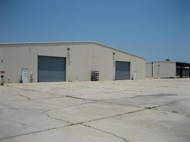

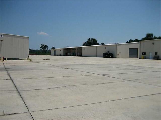
Property Detail
200 Lear Dr
Hammond, LA
14.24A BEING A PT OF LOT 18 OF BUSINESS PARK SUB IN SEC 17 T6SR8E B937 P108 B1038 P133 B1047 P510- 518 B1098 P414 B1164 P91 B
06113990
Tangipahoa
Commercialnec
Louisiana
B and X Area of moderate flood hazard, usually the area between the limits of the 100-year and 500-year floods.
18
2025
14.24 AC
2025
Louisiana South Area
954003
Other Market Areas
52,200 SF
NEARBY LISTINGS FOR SALE OR LEASE
DEMOGRAPHICS near 200 Lear Dr
1 mile
3 mile
5 mile
2025 Total Population
982
23,701
49,250
2030 Population
1,025
24,720
51,247
Pop Growth 2025-2030
+ 4.38%
+ 4.30%
+ 4.05%
Average Age
38
36
37
2025 Total Households
396
9,063
19,089
HH Growth 2025-2030
+ 4.55%
+ 4.60%
+ 4.30%
Median Household Inc
$58,076
$52,748
$50,927
Avg Household Size
2.40
2.30
2.40
2025 Avg HH Vehicles
2.00
2.00
2.00
Median Home Value
$302,027
$250,754
$229,618
Median Year Built
1997
1991
1994
Nearby Places
Map Layers
Map Styles
 Street
 Aerial
Layers
 Traffic
 Biking
Places
Listings with unknown addresses are not visible on the map
- Restaurants
- Banks
- Shops
- Fitness
- Groceries
PUBLIC TRANSPORTATION
COMMUTER RAIL
Hammond Amtrak Station (City of New Orleans - Amtrak)
Drive
Walk
Distance
Hammond Amtrak Station (City of New Orleans - Amtrak)
8 min
3.4 mi
Freight Ports
Port of New Orleans
Drive
Walk
Distance
Port of New Orleans
83 min
62.0 mi
SALE & LEASE HISTORY
LISTING DATE
SALE/LEASE

Sep 25, 2016
For Lease
Jul 29, 2020
For Lease
Nearby Properties
Address
Land Use
TOTAL SIZE
Lot Size
Zoning
Address
Land Use
TOTAL SIZE
Lot Size
Zoning
309,554 SF
98.69 AC
Address
Land Use
TOTAL SIZE
Lot Size
Zoning
666,424 SF
82.56 AC
Address
Land Use
TOTAL SIZE
Lot Size
Zoning
57,600 SF
2.07 AC
Address
Land Use
TOTAL SIZE
Lot Size
Zoning
624,811 SF
41.75 AC
Address
Land Use
TOTAL SIZE
Lot Size
Zoning
1.56 AC
Address
Land Use
TOTAL SIZE
Lot Size
Zoning
52,074 SF
7.40 AC
Address
Land Use
TOTAL SIZE
Lot Size
Zoning
147.07 AC
Address
Land Use
TOTAL SIZE
Lot Size
Zoning
201,555 SF
11.17 AC
Address
Land Use
TOTAL SIZE
Lot Size
Zoning
165,402 SF
28.50 AC
Address
Land Use
TOTAL SIZE
Lot Size
Zoning
353.46 AC
Address
Land Use
TOTAL SIZE
Lot Size
Zoning
90,605 SF
9.76 AC
Address
Land Use
TOTAL SIZE
Lot Size
Zoning
100,000 SF
6.32 AC
Address
Land Use
TOTAL SIZE
Lot Size
Zoning
19,624 SF
4.66 AC
Address
Land Use
TOTAL SIZE
Lot Size
Zoning
62,962 SF
10.36 AC
Address
Land Use
TOTAL SIZE
Lot Size
Zoning
864 SF
0.51 AC
Address
Land Use
TOTAL SIZE
Lot Size
Zoning
34,800 SF
4.48 AC
Address
Land Use
TOTAL SIZE
Lot Size
Zoning
30,000 SF
7.98 AC
Address
Land Use
TOTAL SIZE
Lot Size
Zoning
20,790 SF
10 AC
Address
Land Use
TOTAL SIZE
Lot Size
Zoning
56,176 SF
2.02 AC
Address
Land Use
TOTAL SIZE
Lot Size
Zoning
55,493 SF
1.99 AC
Address
Land Use
TOTAL SIZE
Lot Size
Zoning
21,450 SF
12 AC
Address
Land Use
TOTAL SIZE
Lot Size
Zoning
23,160 SF
6.16 AC
Address
Land Use
TOTAL SIZE
Lot Size
Zoning
45.86 AC
Address
Land Use
TOTAL SIZE
Lot Size
Zoning
20,194 SF
4.60 AC
Address
Land Use
TOTAL SIZE
Lot Size
Zoning
31,136 SF
3.30 AC
Address
Land Use
TOTAL SIZE
Lot Size
Zoning
120,000 SF
5.98 AC
Address
Land Use
TOTAL SIZE
Lot Size
Zoning
27,982 SF
2.13 AC
Address
Land Use
TOTAL SIZE
Lot Size
Zoning
0.97 AC
Address
Land Use
TOTAL SIZE
Lot Size
Zoning
24,000 SF
1.40 AC
The World's #1 Commercial Real Estate Marketplace
Connect with us
© 2026 CoStar Group
The information above has been obtained from sources believed reliable. While we do not doubt its accuracy we have not verified it and make no guarantee, warranty or representation about it. It is your responsibility to independently confirm its accuracy and completeness. Any projections, opinions, assumptions, or estimates used are for example only and do not represent the current or future performance of the property. The value of this transaction to you depends on tax and other factors which should be evaluated by your tax, financial, and legal advisors. You and your advisors should conduct a careful, independent investigation of the property to determine to your satisfaction the suitability of the property for your needs.