Property Record
200 Lindbergh Dr, Winslow, AZ 86047
NEARBY LISTINGS FOR SALE OR LEASE
-
-
View all Winslow listings for sale on LoopNet.com
Property Detail
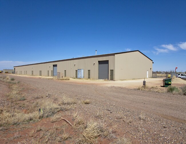
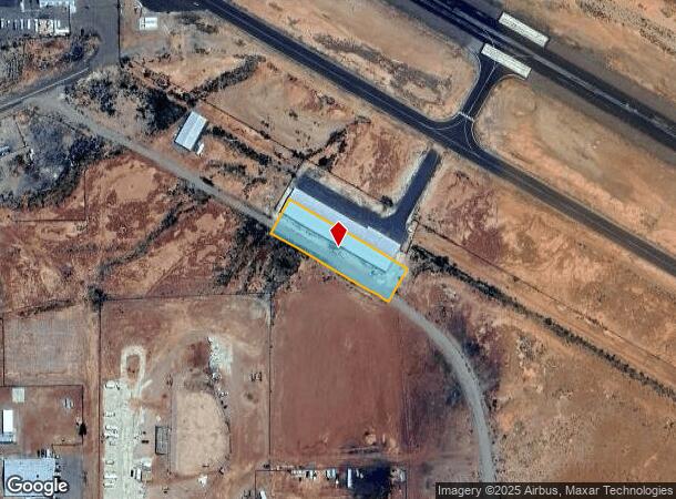
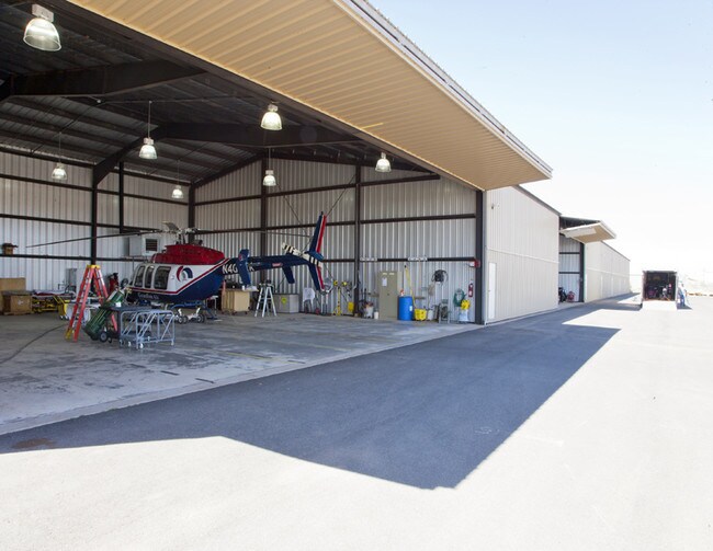
200 Lindbergh Dr
Show Low, AZ
Winslow Airport Industrial Park
103-62-055A
WINSLOW AIRPORT INDUSTRIAL PARK: LOTS 55,56,57 &58 OUT OF 103-62- 055058 FOR2005ROLL
Airport
Navajo
X
Arizona
04017C3014F
55-58
2024
1 AC
2026
Arizona Northeast & Holbrook Area
960600
Other Market Areas
28,000 SF
DEMOGRAPHICS near 200 Lindbergh Dr
1 Mile
3 Mile
5 Mile
2024 Total Population
2,455
9,727
10,611
2029 Population
2,564
10,180
11,166
Pop Growth 2024-2029
+ 4.44%
+ 4.66%
+ 5.23%
Average Age
36
37
37
2024 Total Households
783
3,197
3,501
HH Growth 2024-2029
+ 4.47%
+ 4.60%
+ 5.23%
Median Household Inc
$44,249
$46,638
$49,554
Avg Household Size
2.80
2.70
2.70
2024 Avg HH Vehicles
2.00
2.00
2.00
Median Home Value
$77,631
$105,009
$110,044
Median Year Built
1970
1972
1974
Nearby Places
Map Layers
Map Styles
 Street
 Aerial
- Restaurants
- Banks
- Shops
- Fitness
- Groceries
SALE & LEASE HISTORY
LISTING DATE
SALE/LEASE

Sep 23, 2016
For Sale
Nov 16, 2017
For Sale
Nearby Properties
Address
Land Use
TOTAL SIZE
Lot Size
Zoning
Address
Land Use
TOTAL SIZE
Lot Size
Zoning
50,145 SF
3.55 AC
MUNICIPAL
Address
Land Use
TOTAL SIZE
Lot Size
Zoning
43,652 SF
4.71 AC
MUNICIPAL
Address
Land Use
TOTAL SIZE
Lot Size
Zoning
185,434 SF
7.56 AC
MUNICIPAL
Address
Land Use
TOTAL SIZE
Lot Size
Zoning
15,533 SF
12.69 AC
MUNICIPAL
Address
Land Use
TOTAL SIZE
Lot Size
Zoning
46,793 SF
5.18 AC
MUNICIPAL
Address
Land Use
TOTAL SIZE
Lot Size
Zoning
28,741 SF
6.05 AC
MUNICIPAL
Address
Land Use
TOTAL SIZE
Lot Size
Zoning
44,270 SF
4.47 AC
MUNICIPAL
Address
Land Use
TOTAL SIZE
Lot Size
Zoning
11,323 SF
7.47 AC
MUNICIPAL
Address
Land Use
TOTAL SIZE
Lot Size
Zoning
43,479 SF
7.40 AC
IND-2
Address
Land Use
TOTAL SIZE
Lot Size
Zoning
69,675 SF
18.48 AC
MUNICIPAL
Address
Land Use
TOTAL SIZE
Lot Size
Zoning
11,772 SF
3.60 AC
MUNICIPAL
Address
Land Use
TOTAL SIZE
Lot Size
Zoning
28,866 SF
2.93 AC
MUNICIPAL
Address
Land Use
TOTAL SIZE
Lot Size
Zoning
33,500 SF
6.49 AC
MUNICIPAL
Address
Land Use
TOTAL SIZE
Lot Size
Zoning
37,975 SF
1.07 AC
MUNICIPAL
Address
Land Use
TOTAL SIZE
Lot Size
Zoning
41,459 SF
1.93 AC
MUNICIPAL
Address
Land Use
TOTAL SIZE
Lot Size
Zoning
30,366 SF
0.98 AC
MUNICIPAL
Address
Land Use
TOTAL SIZE
Lot Size
Zoning
28,066 SF
1.17 AC
MUNICIPAL
Address
Land Use
TOTAL SIZE
Lot Size
Zoning
24,864 SF
2.03 AC
MUNICIPAL
Address
Land Use
TOTAL SIZE
Lot Size
Zoning
14,700 SF
20.22 AC
MUNICIPAL
Address
Land Use
TOTAL SIZE
Lot Size
Zoning
11,337 SF
1.04 AC
MUNICIPAL
Address
Land Use
TOTAL SIZE
Lot Size
Zoning
11,840 SF
10 AC
MUNICIPAL
Address
Land Use
TOTAL SIZE
Lot Size
Zoning
22,056 SF
2.57 AC
MUNICIPAL
Address
Land Use
TOTAL SIZE
Lot Size
Zoning
27,841 SF
1.29 AC
MUNICIPAL
Address
Land Use
TOTAL SIZE
Lot Size
Zoning
8,687 SF
1.23 AC
MUNICIPAL
Address
Land Use
TOTAL SIZE
Lot Size
Zoning
45,423 SF
0.47 AC
MUNICIPAL
Address
Land Use
TOTAL SIZE
Lot Size
Zoning
26,727 SF
3.15 AC
MUNICIPAL
Address
Land Use
TOTAL SIZE
Lot Size
Zoning
16,927 SF
13.43 AC
MUNICIPAL
Address
Land Use
TOTAL SIZE
Lot Size
Zoning
10,395 SF
9.80 AC
MUNICIPAL
Address
Land Use
TOTAL SIZE
Lot Size
Zoning
22,047 SF
1.10 AC
MUNICIPAL
The World's #1 Commercial Real Estate Marketplace
Connect with us
© 2025 CoStar Group
The information above has been obtained from sources believed reliable. While we do not doubt its accuracy we have not verified it and make no guarantee, warranty or representation about it. It is your responsibility to independently confirm its accuracy and completeness. Any projections, opinions, assumptions, or estimates used are for example only and do not represent the current or future performance of the property. The value of this transaction to you depends on tax and other factors which should be evaluated by your tax, financial, and legal advisors. You and your advisors should conduct a careful, independent investigation of the property to determine to your satisfaction the suitability of the property for your needs.