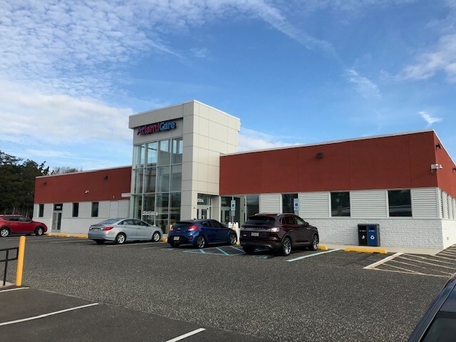
Property Record
200 Mathistown Rd, Little Egg Harbor Twp, NJ 08087
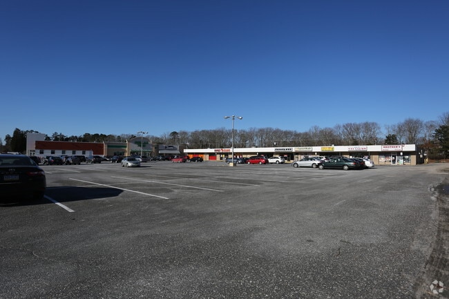

Current Lease Availabilities
General Retail LEASE
$18.00 - $22.00 SF/YR
1,600 - 11,691 SF
Property Detail
200 Mathistown Rd
17-00285-0000-00012
11.387 ACRES
Commercialnec
Ocean
GB
New Jersey
B and X Area of moderate flood hazard, usually the area between the limits of the 100-year and 500-year floods.
12
2025
11.39 AC
2025
Ocean County
736107
Northern New Jersey
51,645 SF
Lakewood-New Brunswick, NJ
NEARBY LISTINGS FOR SALE OR LEASE
DEMOGRAPHICS near 200 Mathistown Rd
1 mile
3 mile
5 mile
2025 Total Population
9,262
24,577
29,472
2030 Population
9,457
25,838
30,908
Pop Growth 2025-2030
+ 2.11%
+ 5.13%
+ 4.87%
Average Age
42
44
45
2025 Total Households
3,684
10,215
12,255
HH Growth 2025-2030
+ 1.52%
+ 4.95%
+ 4.67%
Median Household Inc
$74,353
$85,697
$87,144
Avg Household Size
2.40
2.30
2.30
2025 Avg HH Vehicles
2.00
2.00
2.00
Median Home Value
$277,606
$349,428
$359,639
Median Year Built
1987
1985
1986
Nearby Places
Map Layers
Map Styles
 Street
 Aerial
Layers
 Traffic
 Biking
Places
Listings with unknown addresses are not visible on the map
- Restaurants
- Banks
- Shops
- Fitness
- Groceries
PUBLIC TRANSPORTATION
AIRPORT
Atlantic City International
Drive
Walk
Distance
Atlantic City International
49 min
22.4 mi
Freight Ports
Broadway Terminal - Pier 5
Drive
Walk
Distance
Broadway Terminal - Pier 5
75 min
56.3 mi
Nearby Properties
Address
Land Use
TOTAL SIZE
Lot Size
Zoning
Address
Land Use
TOTAL SIZE
Lot Size
Zoning
61.73 AC
R1A
Address
Land Use
TOTAL SIZE
Lot Size
Zoning
63.04 AC
PSC
Address
Land Use
TOTAL SIZE
Lot Size
Zoning
4.15 AC
GB
Address
Land Use
TOTAL SIZE
Lot Size
Zoning
37.89 AC
GB+
Address
Land Use
TOTAL SIZE
Lot Size
Zoning
9.83 AC
GB
Address
Land Use
TOTAL SIZE
Lot Size
Zoning
43.71 AC
R1A
Address
Land Use
TOTAL SIZE
Lot Size
Zoning
12.17 AC
PRC
Address
Land Use
TOTAL SIZE
Lot Size
Zoning
6.20 AC
GBSG
Address
Land Use
TOTAL SIZE
Lot Size
Zoning
50,000 SF
8.01 AC
GB
Address
Land Use
TOTAL SIZE
Lot Size
Zoning
3.55 AC
R75
Address
Land Use
TOTAL SIZE
Lot Size
Zoning
11.94 AC
GBSG
Address
Land Use
TOTAL SIZE
Lot Size
Zoning
19.53 AC
MF
Address
Land Use
TOTAL SIZE
Lot Size
Zoning
936 SF
32.80 AC
SV
Address
Land Use
TOTAL SIZE
Lot Size
Zoning
600 SF
13.54 AC
GBSG
Address
Land Use
TOTAL SIZE
Lot Size
Zoning
308 SF
4.13 AC
GB
Address
Land Use
TOTAL SIZE
Lot Size
Zoning
32.40 AC
Address
Land Use
TOTAL SIZE
Lot Size
Zoning
53,927 SF
1.87 AC
B2
Address
Land Use
TOTAL SIZE
Lot Size
Zoning
12,669 SF
1.73 AC
B2
Address
Land Use
TOTAL SIZE
Lot Size
Zoning
63.55 AC
R100
Address
Land Use
TOTAL SIZE
Lot Size
Zoning
11,044 SF
4.93 AC
GBSG
Address
Land Use
TOTAL SIZE
Lot Size
Zoning
0.98 AC
GB
Address
Land Use
TOTAL SIZE
Lot Size
Zoning
2,952 SF
3.70 AC
B1
Address
Land Use
TOTAL SIZE
Lot Size
Zoning
5,627 SF
7.42 AC
GB
Address
Land Use
TOTAL SIZE
Lot Size
Zoning
Address
Land Use
TOTAL SIZE
Lot Size
Zoning
14,736 SF
4.83 AC
GB
Address
Land Use
TOTAL SIZE
Lot Size
Zoning
6,764 SF
20.08 AC
B3
Address
Land Use
TOTAL SIZE
Lot Size
Zoning
18,500 SF
3.68 AC
GB
Address
Land Use
TOTAL SIZE
Lot Size
Zoning
79.14 AC
GB+
Address
Land Use
TOTAL SIZE
Lot Size
Zoning
The World's #1 Commercial Real Estate Marketplace
Connect with us
© 2026 CoStar Group
The information above has been obtained from sources believed reliable. While we do not doubt its accuracy we have not verified it and make no guarantee, warranty or representation about it. It is your responsibility to independently confirm its accuracy and completeness. Any projections, opinions, assumptions, or estimates used are for example only and do not represent the current or future performance of the property. The value of this transaction to you depends on tax and other factors which should be evaluated by your tax, financial, and legal advisors. You and your advisors should conduct a careful, independent investigation of the property to determine to your satisfaction the suitability of the property for your needs.