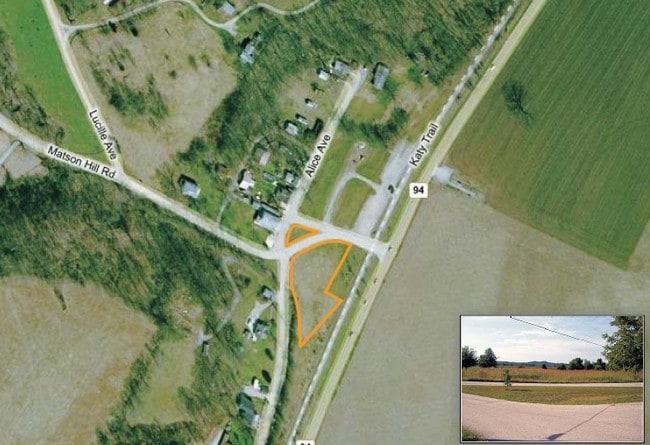
Property Record
200 Matson Hill Rd, Defiance, MO 63341

Save to a Folder
{{folder.Name}}
{{folder.ListingIds.length}} Properties
{{folder.ListingIds.length}} Property
Create a New Folder
Property Detail
200 Matson Hill Rd
St. Louis, MO-IL
PT SUR 20
1-0043-0020-00-0001.4000000
ST. CHARLES
Farms
Missouri
AE The base floodplain where base flood elevations are provided. AE Zones are now used on new format FIRMs instead of A1-A30 Zones.
1
2024
102.67 AC
2025
St Charles County
312204
St. Louis
3,918 SF
NEARBY LISTINGS FOR SALE OR LEASE
-
-
View all Defiance listings for sale on LoopNet.com
DEMOGRAPHICS near 200 Matson Hill Rd
1 mile
3 mile
5 mile
2025 Total Population
71
1,268
4,359
2030 Population
75
1,329
4,525
Pop Growth 2025-2030
+ 5.63%
+ 4.81%
+ 3.81%
Average Age
49
48
47
2025 Total Households
29
506
1,686
HH Growth 2025-2030
+ 3.45%
+ 4.94%
+ 3.91%
Median Household Inc
$112,500
$112,307
$146,714
Avg Household Size
2.20
2.50
2.60
2025 Avg HH Vehicles
2.00
2.00
2.00
Median Home Value
$519,231
$602,941
$612,162
Median Year Built
1967
1991
1992
Nearby Places
Map Layers
Map Styles
 Street
 Aerial
Layers
 Traffic
 Biking
Places
Listings with unknown addresses are not visible on the map
- Restaurants
- Banks
- Shops
- Fitness
- Groceries
PUBLIC TRANSPORTATION
AIRPORT
St Louis Lambert International
Drive
Walk
Distance
St Louis Lambert International
53 min
33.3 mi
Freight Ports
Tulsa Port of Inola
Drive
Walk
Distance
Tulsa Port of Inola
416 min
362.1 mi
Nearby Properties
Address
Land Use
TOTAL SIZE
Lot Size
Zoning
Address
Land Use
TOTAL SIZE
Lot Size
Zoning
1,064 SF
171.05 AC
Address
Land Use
TOTAL SIZE
Lot Size
Zoning
7,380 SF
122.30 AC
Address
Land Use
TOTAL SIZE
Lot Size
Zoning
3,840 SF
102.79 AC
Address
Land Use
TOTAL SIZE
Lot Size
Zoning
71.34 AC
AA1
Address
Land Use
TOTAL SIZE
Lot Size
Zoning
68.50 AC
AA1
Address
Land Use
TOTAL SIZE
Lot Size
Zoning
61.81 AC
Address
Land Use
TOTAL SIZE
Lot Size
Zoning
9,231 SF
42 AC
Address
Land Use
TOTAL SIZE
Lot Size
Zoning
13,681 SF
336.53 AC
AA1
Address
Land Use
TOTAL SIZE
Lot Size
Zoning
38.92 AC
AF0
Address
Land Use
TOTAL SIZE
Lot Size
Zoning
11,080 SF
29.50 AC
Address
Land Use
TOTAL SIZE
Lot Size
Zoning
9,546 SF
0.50 AC
CD
Address
Land Use
TOTAL SIZE
Lot Size
Zoning
22,418 SF
232.29 AC
Address
Land Use
TOTAL SIZE
Lot Size
Zoning
377.21 AC
AA1
Address
Land Use
TOTAL SIZE
Lot Size
Zoning
7,821 SF
11.89 AC
AA1
Address
Land Use
TOTAL SIZE
Lot Size
Zoning
18,072 SF
60.15 AC
Address
Land Use
TOTAL SIZE
Lot Size
Zoning
9,746 SF
16.90 AC
AA1
Address
Land Use
TOTAL SIZE
Lot Size
Zoning
2,752 SF
25.31 AC
Address
Land Use
TOTAL SIZE
Lot Size
Zoning
109.93 AC
Address
Land Use
TOTAL SIZE
Lot Size
Zoning
82.68 AC
AA1
Address
Land Use
TOTAL SIZE
Lot Size
Zoning
7,307 SF
28.85 AC
AA1
Address
Land Use
TOTAL SIZE
Lot Size
Zoning
5,207 SF
10.16 AC
Address
Land Use
TOTAL SIZE
Lot Size
Zoning
10,258 SF
34 AC
Address
Land Use
TOTAL SIZE
Lot Size
Zoning
5,428 SF
2.20 AC
CD
Address
Land Use
TOTAL SIZE
Lot Size
Zoning
35.48 AC
Address
Land Use
TOTAL SIZE
Lot Size
Zoning
3,358 SF
27 AC
Address
Land Use
TOTAL SIZE
Lot Size
Zoning
1,280 SF
14.19 AC
Address
Land Use
TOTAL SIZE
Lot Size
Zoning
5,056 SF
0.30 AC
Address
Land Use
TOTAL SIZE
Lot Size
Zoning
5,307 SF
10.27 AC
Address
Land Use
TOTAL SIZE
Lot Size
Zoning
4,386 SF
47.93 AC
Address
Land Use
TOTAL SIZE
Lot Size
Zoning
6,932 SF
6.36 AC
The World's #1 Commercial Real Estate Marketplace
Connect with us
© 2026 CoStar Group
The information above has been obtained from sources believed reliable. While we do not doubt its accuracy we have not verified it and make no guarantee, warranty or representation about it. It is your responsibility to independently confirm its accuracy and completeness. Any projections, opinions, assumptions, or estimates used are for example only and do not represent the current or future performance of the property. The value of this transaction to you depends on tax and other factors which should be evaluated by your tax, financial, and legal advisors. You and your advisors should conduct a careful, independent investigation of the property to determine to your satisfaction the suitability of the property for your needs.