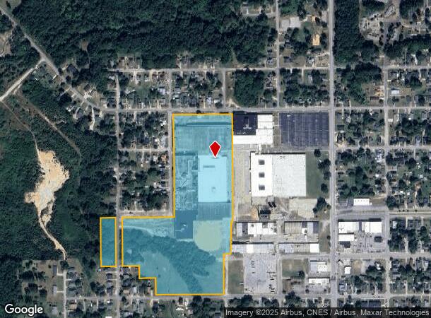
Property Record
200 N 13Th St, Erwin, NC 28339
NEARBY LISTINGS FOR SALE OR LEASE
-
-
View all Erwin listings for lease on LoopNet.com
Property Detail
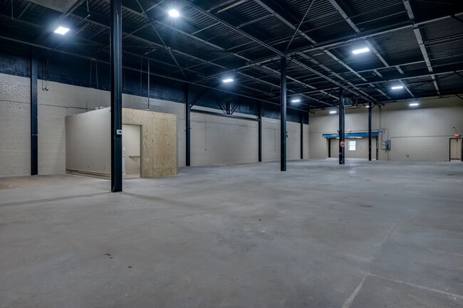
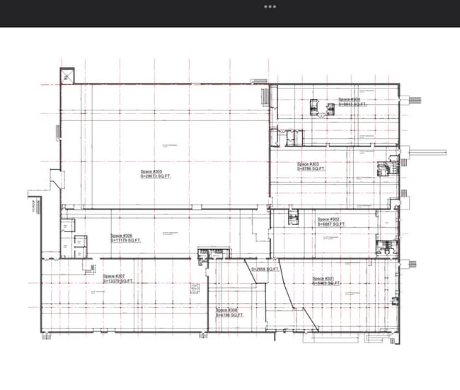
200 N 13Th St
Other Market Areas
Prap2308-0006
Dunn, NC
LOT#1 200 N 13 LLC MAP#2023-401
060586 0275 03
Harnett
Commercialcondominium
North Carolina
2025
1
2025
27.93 AC
070500
North Carolina Southeast Area
DEMOGRAPHICS near 200 N 13Th St
1 Mile
3 Mile
5 Mile
2024 Total Population
3,615
9,186
21,751
2029 Population
3,973
10,088
23,940
Pop Growth 2024-2029
+ 9.90%
+ 9.82%
+ 10.06%
Average Age
42
43
42
2024 Total Households
1,455
3,673
8,919
HH Growth 2024-2029
+ 10.17%
+ 10.13%
+ 10.36%
Median Household Inc
$51,555
$50,103
$46,907
Avg Household Size
2.40
2.40
2.40
2024 Avg HH Vehicles
2.00
2.00
2.00
Median Home Value
$128,417
$141,641
$150,159
Median Year Built
1966
1975
1976
Nearby Places
Map Layers
Map Styles
 Street
 Aerial
- Restaurants
- Banks
- Shops
- Fitness
- Groceries
PUBLIC TRANSPORTATION
AIRPORT
Fayetteville Regional/Grannis Field
DRIVE
WALK
Distance
Fayetteville Regional/Grannis Field
45 min
33.0 mi
Freight Ports
Port of Wilmington
DRIVE
WALK
Distance
Port of Wilmington
134 min
108.8 mi
SALE & LEASE HISTORY
LISTING DATE
SALE/LEASE

Jul 19, 2024
For Lease
Nearby Properties
Address
Land Use
TOTAL SIZE
Lot Size
Zoning
Address
Land Use
TOTAL SIZE
Lot Size
Zoning
73.86 AC
Address
Land Use
TOTAL SIZE
Lot Size
Zoning
15.37 AC
R10
Address
Land Use
TOTAL SIZE
Lot Size
Zoning
292,616 SF
49.62 AC
M1
Address
Land Use
TOTAL SIZE
Lot Size
Zoning
81,250 SF
12.60 AC
I10
Address
Land Use
TOTAL SIZE
Lot Size
Zoning
52,334 SF
8.72 AC
R10
Address
Land Use
TOTAL SIZE
Lot Size
Zoning
11,896 SF
1.61 AC
B2
Address
Land Use
TOTAL SIZE
Lot Size
Zoning
43,834 SF
3.07 AC
R10
Address
Land Use
TOTAL SIZE
Lot Size
Zoning
60,864 SF
6.33 AC
C2
Address
Land Use
TOTAL SIZE
Lot Size
Zoning
8,760 SF
2.58 AC
CB
Address
Land Use
TOTAL SIZE
Lot Size
Zoning
9,095 SF
3.12 AC
OI
Address
Land Use
TOTAL SIZE
Lot Size
Zoning
3,711 SF
1.50 AC
C3
Address
Land Use
TOTAL SIZE
Lot Size
Zoning
16,000 SF
1.53 AC
B2
Address
Land Use
TOTAL SIZE
Lot Size
Zoning
3,274 SF
1.20 AC
C3
Address
Land Use
TOTAL SIZE
Lot Size
Zoning
17,132 SF
1.98 AC
Address
Land Use
TOTAL SIZE
Lot Size
Zoning
2,459 SF
1.06 AC
C3
Address
Land Use
TOTAL SIZE
Lot Size
Zoning
9,204 SF
9.64 AC
RA30
Address
Land Use
TOTAL SIZE
Lot Size
Zoning
3,546 SF
1.45 AC
B2
Address
Land Use
TOTAL SIZE
Lot Size
Zoning
11,735 SF
3.07 AC
R10
Address
Land Use
TOTAL SIZE
Lot Size
Zoning
2,471 SF
1.14 AC
C3
Address
Land Use
TOTAL SIZE
Lot Size
Zoning
10,900 SF
1.68 AC
Address
Land Use
TOTAL SIZE
Lot Size
Zoning
5,658 SF
0.68 AC
R10
Address
Land Use
TOTAL SIZE
Lot Size
Zoning
4,867 SF
0.92 AC
C2
Address
Land Use
TOTAL SIZE
Lot Size
Zoning
10,500 SF
3.70 AC
Address
Land Use
TOTAL SIZE
Lot Size
Zoning
40,252 SF
15.10 AC
R6
Address
Land Use
TOTAL SIZE
Lot Size
Zoning
14,334 SF
0.76 AC
R10
Address
Land Use
TOTAL SIZE
Lot Size
Zoning
36,522 SF
4.06 AC
C3
Address
Land Use
TOTAL SIZE
Lot Size
Zoning
16,872 SF
2.16 AC
Address
Land Use
TOTAL SIZE
Lot Size
Zoning
11,472 SF
1.33 AC
C2
Address
Land Use
TOTAL SIZE
Lot Size
Zoning
7,980 SF
2.56 AC
OI
The World's #1 Commercial Real Estate Marketplace
Connect with us
© 2026 CoStar Group
The information above has been obtained from sources believed reliable. While we do not doubt its accuracy we have not verified it and make no guarantee, warranty or representation about it. It is your responsibility to independently confirm its accuracy and completeness. Any projections, opinions, assumptions, or estimates used are for example only and do not represent the current or future performance of the property. The value of this transaction to you depends on tax and other factors which should be evaluated by your tax, financial, and legal advisors. You and your advisors should conduct a careful, independent investigation of the property to determine to your satisfaction the suitability of the property for your needs.