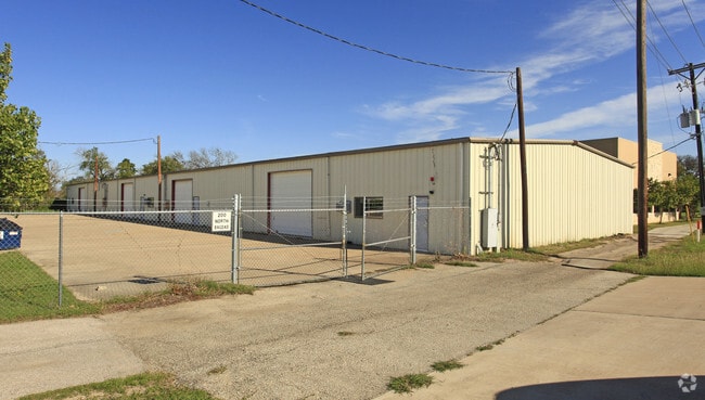
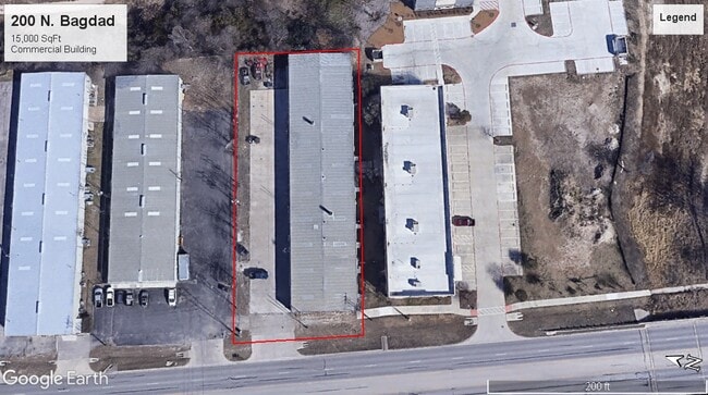
Property Record
200 N Bagdad Rd, Leander, TX 78641

Property Detail
200 N Bagdad Rd
Austin-Round Rock-San Marcos, TX
S3102 - BAGDAD MEADOWS, LOT 4/PT, ACRES 0.8602
R032414
Williamson
Commercialnec
Texas
B and X Area of moderate flood hazard, usually the area between the limits of the 100-year and 500-year floods.
4
2024
0.86 AC
2025
Georgetown
020331
Austin
15,000 SF
NEARBY LISTINGS FOR SALE OR LEASE
DEMOGRAPHICS near 200 N Bagdad Rd
1 mile
3 mile
5 mile
2025 Total Population
15,943
66,668
130,846
2030 Population
18,532
76,783
150,597
Pop Growth 2025-2030
+ 16.24%
+ 15.17%
+ 15.09%
Average Age
36
37
37
2025 Total Households
5,503
22,979
45,508
HH Growth 2025-2030
+ 16.70%
+ 15.70%
+ 15.60%
Median Household Inc
$115,198
$129,865
$128,025
Avg Household Size
2.90
2.90
2.90
2025 Avg HH Vehicles
2.00
2.00
2.00
Median Home Value
$443,540
$477,279
$477,284
Median Year Built
2010
2010
2010
Nearby Places
Map Layers
Map Styles
 Street
 Aerial
Transit
 Traffic
 Biking
Places
Listings with unknown addresses are not visible on the map
- Restaurants
- Banks
- Shops
- Fitness
- Groceries
PUBLIC TRANSPORTATION
AIRPORT
Austin-Bergstrom International
Drive
Walk
Distance
Austin-Bergstrom International
52 min
38.7 mi
Freight Ports
Calhoun Port
Drive
Walk
Distance
Calhoun Port
218 min
182.2 mi
SALE & LEASE HISTORY
LISTING DATE
SALE/LEASE

Jan 16, 2024
For Sale
Jan 15, 2019
For Lease
Dec 02, 2016
For Lease
Nearby Properties
Address
Land Use
TOTAL SIZE
Lot Size
Zoning
Address
Land Use
TOTAL SIZE
Lot Size
Zoning
435,000 SF
88.70 AC
Address
Land Use
TOTAL SIZE
Lot Size
Zoning
106,000 SF
72.51 AC
Address
Land Use
TOTAL SIZE
Lot Size
Zoning
341,700 SF
17.71 AC
Address
Land Use
TOTAL SIZE
Lot Size
Zoning
1 SF
138.94 AC
Address
Land Use
TOTAL SIZE
Lot Size
Zoning
287,118 SF
9.26 AC
Address
Land Use
TOTAL SIZE
Lot Size
Zoning
327,784 SF
22.95 AC
Address
Land Use
TOTAL SIZE
Lot Size
Zoning
310,297 SF
15.01 AC
Address
Land Use
TOTAL SIZE
Lot Size
Zoning
325,045 SF
22.75 AC
Address
Land Use
TOTAL SIZE
Lot Size
Zoning
31.42 AC
Address
Land Use
TOTAL SIZE
Lot Size
Zoning
285,365 SF
12.24 AC
Address
Land Use
TOTAL SIZE
Lot Size
Zoning
246,060 SF
9.30 AC
Address
Land Use
TOTAL SIZE
Lot Size
Zoning
249,826 SF
37.40 AC
Address
Land Use
TOTAL SIZE
Lot Size
Zoning
238,420 SF
13.72 AC
Address
Land Use
TOTAL SIZE
Lot Size
Zoning
117,076 SF
15.51 AC
Address
Land Use
TOTAL SIZE
Lot Size
Zoning
238,343 SF
12.08 AC
Address
Land Use
TOTAL SIZE
Lot Size
Zoning
234,214 SF
19.63 AC
Address
Land Use
TOTAL SIZE
Lot Size
Zoning
195,426 SF
12.11 AC
Address
Land Use
TOTAL SIZE
Lot Size
Zoning
232,172 SF
10.43 AC
Address
Land Use
TOTAL SIZE
Lot Size
Zoning
341,700 SF
9.90 AC
Address
Land Use
TOTAL SIZE
Lot Size
Zoning
193,600 SF
70.78 AC
Address
Land Use
TOTAL SIZE
Lot Size
Zoning
193,011 SF
8.91 AC
Address
Land Use
TOTAL SIZE
Lot Size
Zoning
229,977 SF
16.85 AC
Address
Land Use
TOTAL SIZE
Lot Size
Zoning
94,861 SF
12.72 AC
Address
Land Use
TOTAL SIZE
Lot Size
Zoning
194,695 SF
9.56 AC
Address
Land Use
TOTAL SIZE
Lot Size
Zoning
191,654 SF
4.57 AC
2-LI
Address
Land Use
TOTAL SIZE
Lot Size
Zoning
264,140 SF
21.37 AC
Address
Land Use
TOTAL SIZE
Lot Size
Zoning
194,695 SF
5.09 AC
Address
Land Use
TOTAL SIZE
Lot Size
Zoning
175,521 SF
14.76 AC
Address
Land Use
TOTAL SIZE
Lot Size
Zoning
193,864 SF
11.22 AC
Address
Land Use
TOTAL SIZE
Lot Size
Zoning
20.47 AC
The World's #1 Commercial Real Estate Marketplace
Connect with us
© 2026 CoStar Group
The information above has been obtained from sources believed reliable. While we do not doubt its accuracy we have not verified it and make no guarantee, warranty or representation about it. It is your responsibility to independently confirm its accuracy and completeness. Any projections, opinions, assumptions, or estimates used are for example only and do not represent the current or future performance of the property. The value of this transaction to you depends on tax and other factors which should be evaluated by your tax, financial, and legal advisors. You and your advisors should conduct a careful, independent investigation of the property to determine to your satisfaction the suitability of the property for your needs.