Property Record
200 N Carrier Pkwy, Grand Prairie, TX 75050
Current Lease Availabilities
NEARBY LISTINGS FOR SALE OR LEASE
Property Detail
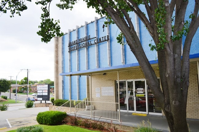
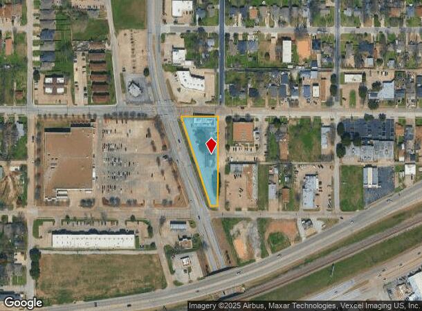
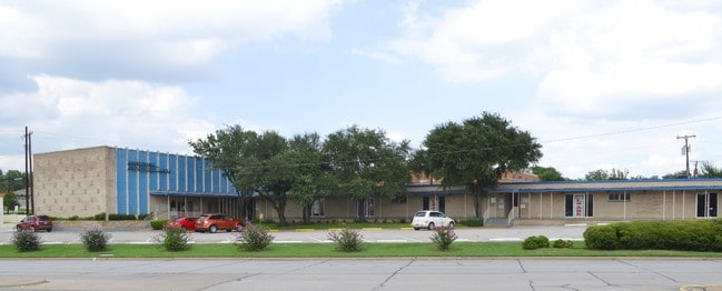
200 N Carrier Pkwy
Dallas-Fort Worth-Arlington, TX
Dalworth Park
28052500080010000
DALWORTH PARK BLK 8 LOTS 1, 2 & 3 INT202400220365 DD10032024 CO-DC 0525000800100 5CP05250008
Medicalbuilding
Dallas
X
Texas
48439C0360L
1,2,3
2024
0.97 AC
2025
Grand Prairie
015500
Dallas/Ft Worth
15,688 SF
DEMOGRAPHICS near 200 N Carrier Pkwy
1 Mile
3 Mile
5 Mile
2024 Total Population
13,768
83,946
225,990
2029 Population
13,740
84,322
230,403
Pop Growth 2024-2029
(0.20%)
+ 0.45%
+ 1.95%
Average Age
35
34
35
2024 Total Households
4,472
27,487
78,787
HH Growth 2024-2029
(0.51%)
+ 0.35%
+ 2.18%
Median Household Inc
$42,983
$50,946
$54,617
Avg Household Size
3.00
3.00
2.80
2024 Avg HH Vehicles
2.00
2.00
2.00
Median Home Value
$146,191
$180,981
$196,110
Median Year Built
1966
1976
1981
Nearby Places
- Restaurants
- Banks
- Shops
- Fitness
- Groceries
PUBLIC TRANSPORTATION
COMMUTER RAIL
DRIVE
WALK
Distance
8 min
5.7 mi
DRIVE
WALK
Distance
13 min
7.0 mi
AIRPORT
Dallas-Fort Worth International
DRIVE
WALK
Distance
Dallas-Fort Worth International
19 min
13.1 mi
Dallas Love Field
DRIVE
WALK
Distance
Dallas Love Field
27 min
19.2 mi
Nearby Properties
Address
Land Use
TOTAL SIZE
Lot Size
Zoning
Address
Land Use
TOTAL SIZE
Lot Size
Zoning
2,395,314 SF
152.04 AC
Address
Land Use
TOTAL SIZE
Lot Size
Zoning
1,577,320 SF
122.55 AC
Z123
Address
Land Use
TOTAL SIZE
Lot Size
Zoning
860,445 SF
50.39 AC
Z123
Address
Land Use
TOTAL SIZE
Lot Size
Zoning
703,500 SF
47.38 AC
Z236
Address
Land Use
TOTAL SIZE
Lot Size
Zoning
496,283 SF
246.29 AC
Z236
Address
Land Use
TOTAL SIZE
Lot Size
Zoning
1,261,810 SF
80.53 AC
Address
Land Use
TOTAL SIZE
Lot Size
Zoning
450,535 SF
27.23 AC
Address
Land Use
TOTAL SIZE
Lot Size
Zoning
680,900 SF
32.25 AC
Z236
Address
Land Use
TOTAL SIZE
Lot Size
Zoning
334,057 SF
20.05 AC
Z312
Address
Land Use
TOTAL SIZE
Lot Size
Zoning
753,721 SF
42.65 AC
Address
Land Use
TOTAL SIZE
Lot Size
Zoning
358,350 SF
13.15 AC
Address
Land Use
TOTAL SIZE
Lot Size
Zoning
1,054,767 SF
37.45 AC
Z123
Address
Land Use
TOTAL SIZE
Lot Size
Zoning
603,000 SF
32.80 AC
Z123
Address
Land Use
TOTAL SIZE
Lot Size
Zoning
531,072 SF
26.50 AC
Z236
Address
Land Use
TOTAL SIZE
Lot Size
Zoning
264,010 SF
34.50 AC
Z190
Address
Land Use
TOTAL SIZE
Lot Size
Zoning
197,000 SF
25.51 AC
Z236
Address
Land Use
TOTAL SIZE
Lot Size
Zoning
228,210 SF
12.28 AC
Z190
Address
Land Use
TOTAL SIZE
Lot Size
Zoning
283,087 SF
15.22 AC
Z236
Address
Land Use
TOTAL SIZE
Lot Size
Zoning
436,343 SF
5.36 AC
Z236
Address
Land Use
TOTAL SIZE
Lot Size
Zoning
150,000 SF
12.95 AC
Address
Land Use
TOTAL SIZE
Lot Size
Zoning
266,448 SF
17 AC
Z97
Address
Land Use
TOTAL SIZE
Lot Size
Zoning
224,486 SF
18.11 AC
Z236
Address
Land Use
TOTAL SIZE
Lot Size
Zoning
83,938 SF
22.46 AC
Address
Land Use
TOTAL SIZE
Lot Size
Zoning
251,392 SF
14.54 AC
Z190
Address
Land Use
TOTAL SIZE
Lot Size
Zoning
492,972 SF
24.23 AC
Address
Land Use
TOTAL SIZE
Lot Size
Zoning
436,014 SF
47.53 AC
Z236
Address
Land Use
TOTAL SIZE
Lot Size
Zoning
226,438 SF
12.98 AC
Z190
Address
Land Use
TOTAL SIZE
Lot Size
Zoning
196,056 SF
11.19 AC
Address
Land Use
TOTAL SIZE
Lot Size
Zoning
346,388 SF
17.75 AC
Address
Land Use
TOTAL SIZE
Lot Size
Zoning
746,852 SF
34.91 AC
The World's #1 Commercial Real Estate Marketplace
Connect with us
© 2025 CoStar Group
The information above has been obtained from sources believed reliable. While we do not doubt its accuracy we have not verified it and make no guarantee, warranty or representation about it. It is your responsibility to independently confirm its accuracy and completeness. Any projections, opinions, assumptions, or estimates used are for example only and do not represent the current or future performance of the property. The value of this transaction to you depends on tax and other factors which should be evaluated by your tax, financial, and legal advisors. You and your advisors should conduct a careful, independent investigation of the property to determine to your satisfaction the suitability of the property for your needs.