Property Record
200 N Keene St, Columbia, MO 65201
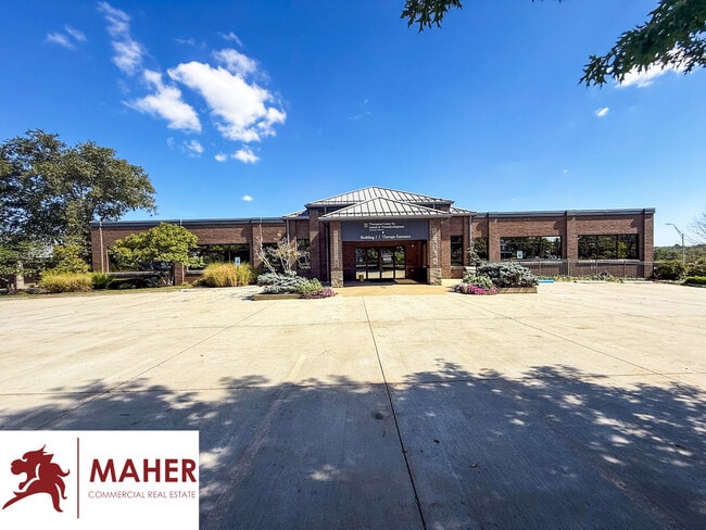
This Property Is For Sale
NEARBY LISTINGS FOR SALE OR LEASE
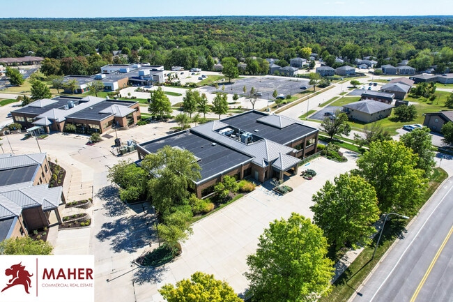
Property Detail
200 N Keene St
Columbia, MO
Keene Estates
17-104-00-01-075-00-01
KEENE ESTATES PLAT 17 ADMIN PLAT LOT 1-A
Officebuilding
Boone
X
Missouri
29019C0283E
1-a
0
1.24 AC
2025
Columbia/Jefferson City
001003
Other Market Areas
26,544 SF
DEMOGRAPHICS near 200 N Keene St
1 Mile
3 Mile
5 Mile
2024 Total Population
3,917
62,831
117,399
2029 Population
4,022
65,272
122,010
Pop Growth 2024-2029
+ 2.68%
+ 3.89%
+ 3.93%
Average Age
37
33
35
2024 Total Households
1,919
24,462
48,496
HH Growth 2024-2029
+ 2.76%
+ 4.24%
+ 4.21%
Median Household Inc
$52,680
$50,262
$60,060
Avg Household Size
2.00
2.10
2.20
2024 Avg HH Vehicles
2.00
2.00
2.00
Median Home Value
$193,700
$201,103
$231,340
Median Year Built
1985
1989
1990
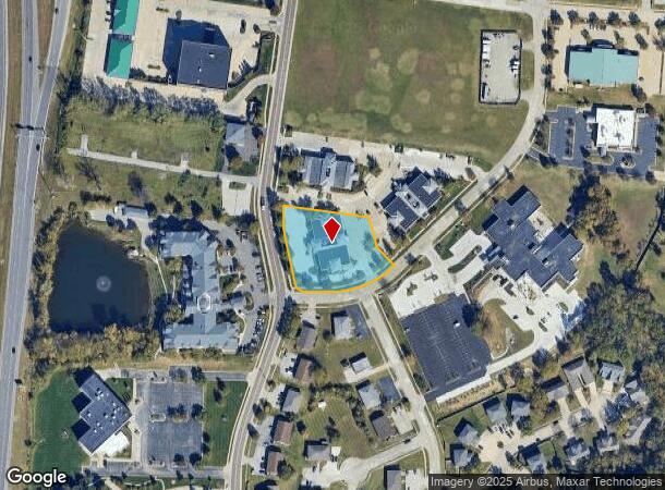
Nearby Places
Map Layers
Map Styles
 Street
 Aerial
- Restaurants
- Banks
- Shops
- Fitness
- Groceries
PUBLIC TRANSPORTATION
AIRPORT
Columbia Regional
DRIVE
WALK
Distance
Columbia Regional
16 min
11.9 mi
Freight Ports
Tulsa Port of Inola
DRIVE
WALK
Distance
Tulsa Port of Inola
377 min
334.5 mi
Nearby Properties
Address
Land Use
TOTAL SIZE
Lot Size
Zoning
Address
Land Use
TOTAL SIZE
Lot Size
Zoning
171,157 SF
5.60 AC
O1
Address
Land Use
TOTAL SIZE
Lot Size
Zoning
149,686 SF
15.26 AC
MC
Address
Land Use
TOTAL SIZE
Lot Size
Zoning
6,390 SF
28.23 AC
Address
Land Use
TOTAL SIZE
Lot Size
Zoning
40,016 SF
2.13 AC
O1
Address
Land Use
TOTAL SIZE
Lot Size
Zoning
3,808 SF
0.39 AC
C2
Address
Land Use
TOTAL SIZE
Lot Size
Zoning
234,111 SF
2.27 AC
Address
Land Use
TOTAL SIZE
Lot Size
Zoning
50,304 SF
8.78 AC
C1
Address
Land Use
TOTAL SIZE
Lot Size
Zoning
11,760 SF
22.98 AC
Address
Land Use
TOTAL SIZE
Lot Size
Zoning
159,169 SF
1.26 AC
R3
Address
Land Use
TOTAL SIZE
Lot Size
Zoning
89,638 SF
6.42 AC
C3
Address
Land Use
TOTAL SIZE
Lot Size
Zoning
52,568 SF
9.50 AC
Address
Land Use
TOTAL SIZE
Lot Size
Zoning
57,520 SF
56.57 AC
Address
Land Use
TOTAL SIZE
Lot Size
Zoning
134,625 SF
0.79 AC
C2
Address
Land Use
TOTAL SIZE
Lot Size
Zoning
45,750 SF
0.66 AC
R3
Address
Land Use
TOTAL SIZE
Lot Size
Zoning
12,098 SF
45.85 AC
Address
Land Use
TOTAL SIZE
Lot Size
Zoning
38,500 SF
3.10 AC
O1
Address
Land Use
TOTAL SIZE
Lot Size
Zoning
87,060 SF
0.37 AC
R3
Address
Land Use
TOTAL SIZE
Lot Size
Zoning
125,487 SF
3.36 AC
Address
Land Use
TOTAL SIZE
Lot Size
Zoning
97,092 SF
1.56 AC
Address
Land Use
TOTAL SIZE
Lot Size
Zoning
33,732 SF
3.34 AC
O1
Address
Land Use
TOTAL SIZE
Lot Size
Zoning
136,448 SF
0.78 AC
C2
Address
Land Use
TOTAL SIZE
Lot Size
Zoning
3,420 SF
18.60 AC
R3
Address
Land Use
TOTAL SIZE
Lot Size
Zoning
8,678 SF
23.15 AC
R3
Address
Land Use
TOTAL SIZE
Lot Size
Zoning
264,960 SF
40.01 AC
R1
Address
Land Use
TOTAL SIZE
Lot Size
Zoning
148,500 SF
22.62 AC
R3
Address
Land Use
TOTAL SIZE
Lot Size
Zoning
68,408 SF
4.38 AC
O1
Address
Land Use
TOTAL SIZE
Lot Size
Zoning
184,413 SF
17.63 AC
CP
Address
Land Use
TOTAL SIZE
Lot Size
Zoning
119,520 SF
12.56 AC
Address
Land Use
TOTAL SIZE
Lot Size
Zoning
17,589 SF
0.52 AC
C2
Address
Land Use
TOTAL SIZE
Lot Size
Zoning
70,783 SF
5.07 AC
O1
The World's #1 Commercial Real Estate Marketplace
Connect with us
© 2025 CoStar Group
The information above has been obtained from sources believed reliable. While we do not doubt its accuracy we have not verified it and make no guarantee, warranty or representation about it. It is your responsibility to independently confirm its accuracy and completeness. Any projections, opinions, assumptions, or estimates used are for example only and do not represent the current or future performance of the property. The value of this transaction to you depends on tax and other factors which should be evaluated by your tax, financial, and legal advisors. You and your advisors should conduct a careful, independent investigation of the property to determine to your satisfaction the suitability of the property for your needs.