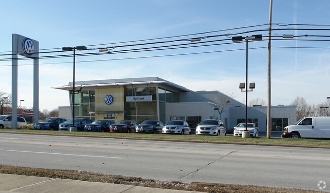
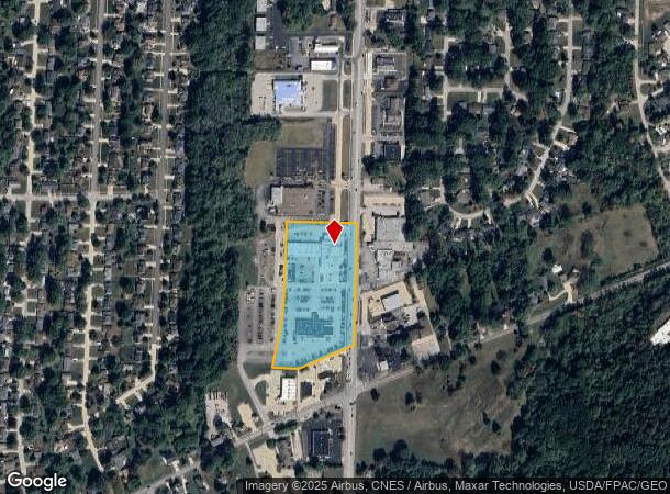
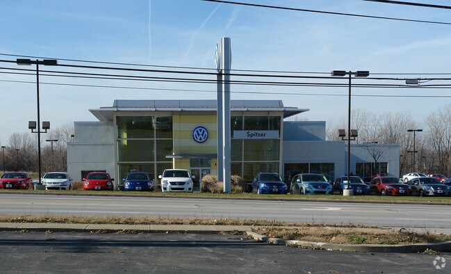
Property Record
200 N Leavitt Rd, Amherst, OH 44001
NEARBY LISTINGS FOR SALE OR LEASE
Property Detail
200 N Leavitt Rd
05-00-039-108-077
Orchard Hill Sub No 1
Vehiclerentalsvehiclesales
VICTORY CHEVY/OLDS
X
Lorain
39093C0112D
Ohio
2024
6.60 AC
2024
Lorain County
050200
Cleveland
48,978 SF
Cleveland-Elyria, OH
DEMOGRAPHICS near 200 N Leavitt Rd
1 Mile
3 Mile
5 Mile
2024 Total Population
6,078
44,648
91,034
2029 Population
6,292
46,522
95,024
Pop Growth 2024-2029
+ 3.52%
+ 4.20%
+ 4.38%
Average Age
45
43
41
2024 Total Households
2,556
18,624
38,000
HH Growth 2024-2029
+ 3.44%
+ 4.18%
+ 4.36%
Median Household Inc
$80,706
$67,597
$48,989
Avg Household Size
2.40
2.30
2.30
2024 Avg HH Vehicles
2.00
2.00
2.00
Median Home Value
$170,659
$176,712
$148,978
Median Year Built
1967
1973
1966
Nearby Places
Map Layers
Map Styles
 Street
 Aerial
- Restaurants
- Banks
- Shops
- Fitness
- Groceries
PUBLIC TRANSPORTATION
COMMUTER RAIL
Elyria Amtrak (Capitol Limited - Amtrak, Lake Shore Limited - Amtrak)
DRIVE
WALK
Distance
Elyria Amtrak (Capitol Limited - Amtrak, Lake Shore Limited - Amtrak)
14 min
8.9 mi
AIRPORT
Cleveland-Hopkins International
DRIVE
WALK
Distance
Cleveland-Hopkins International
34 min
23.7 mi
Freight Ports
Port of Toledo
DRIVE
WALK
Distance
Port of Toledo
104 min
85.6 mi
Nearby Properties
Address
Land Use
TOTAL SIZE
Lot Size
Zoning
Address
Land Use
TOTAL SIZE
Lot Size
Zoning
1,040,560 SF
28.68 AC
Address
Land Use
TOTAL SIZE
Lot Size
Zoning
33,339 SF
30.60 AC
Address
Land Use
TOTAL SIZE
Lot Size
Zoning
187,340 SF
42.98 AC
Address
Land Use
TOTAL SIZE
Lot Size
Zoning
118,624 SF
19.80 AC
Address
Land Use
TOTAL SIZE
Lot Size
Zoning
111,373 SF
9.35 AC
Address
Land Use
TOTAL SIZE
Lot Size
Zoning
160,080 SF
14.89 AC
Address
Land Use
TOTAL SIZE
Lot Size
Zoning
43,576 SF
12.37 AC
Address
Land Use
TOTAL SIZE
Lot Size
Zoning
191,168 SF
20.70 AC
Address
Land Use
TOTAL SIZE
Lot Size
Zoning
35,502 SF
23.29 AC
Address
Land Use
TOTAL SIZE
Lot Size
Zoning
36.66 AC
Address
Land Use
TOTAL SIZE
Lot Size
Zoning
53,266 SF
12.90 AC
Address
Land Use
TOTAL SIZE
Lot Size
Zoning
178,140 SF
15.67 AC
Address
Land Use
TOTAL SIZE
Lot Size
Zoning
30,744 SF
5.10 AC
Address
Land Use
TOTAL SIZE
Lot Size
Zoning
31,871 SF
6.90 AC
Address
Land Use
TOTAL SIZE
Lot Size
Zoning
9,880 SF
3.90 AC
Address
Land Use
TOTAL SIZE
Lot Size
Zoning
22,894 SF
9.60 AC
Address
Land Use
TOTAL SIZE
Lot Size
Zoning
52,602 SF
9.31 AC
Address
Land Use
TOTAL SIZE
Lot Size
Zoning
54,831 SF
3.93 AC
Address
Land Use
TOTAL SIZE
Lot Size
Zoning
66,196 SF
7.05 AC
Address
Land Use
TOTAL SIZE
Lot Size
Zoning
80,852 SF
9.41 AC
Address
Land Use
TOTAL SIZE
Lot Size
Zoning
72,753 SF
3.03 AC
Address
Land Use
TOTAL SIZE
Lot Size
Zoning
57,730 SF
7.35 AC
Address
Land Use
TOTAL SIZE
Lot Size
Zoning
67,408 SF
14.83 AC
Address
Land Use
TOTAL SIZE
Lot Size
Zoning
64,442 SF
7.67 AC
Address
Land Use
TOTAL SIZE
Lot Size
Zoning
138,499 SF
10.07 AC
Address
Land Use
TOTAL SIZE
Lot Size
Zoning
76,819 SF
3.62 AC
Address
Land Use
TOTAL SIZE
Lot Size
Zoning
139,368 SF
13.48 AC
Address
Land Use
TOTAL SIZE
Lot Size
Zoning
23,068 SF
2.94 AC
Address
Land Use
TOTAL SIZE
Lot Size
Zoning
17,787 SF
3.67 AC
Address
Land Use
TOTAL SIZE
Lot Size
Zoning
127,146 SF
9.54 AC
The World's #1 Commercial Real Estate Marketplace
Connect with us
© 2026 CoStar Group
The information above has been obtained from sources believed reliable. While we do not doubt its accuracy we have not verified it and make no guarantee, warranty or representation about it. It is your responsibility to independently confirm its accuracy and completeness. Any projections, opinions, assumptions, or estimates used are for example only and do not represent the current or future performance of the property. The value of this transaction to you depends on tax and other factors which should be evaluated by your tax, financial, and legal advisors. You and your advisors should conduct a careful, independent investigation of the property to determine to your satisfaction the suitability of the property for your needs.