Property Record
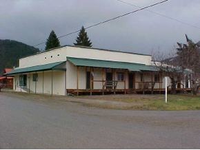
200 N Main St, Clark Fork, ID 83811

Property Detail
200 N Main St
Sandpoint, ID
2-55N-2E NAGELS AMENDED BLK 6 LOTS 8,9 & 10 KIRKMAN BLDG
RPC00-590-06008BA
BONNER
Commercialnec
Idaho
2025
8-10
2025
0.26 AC
950100
Bonner
5,400 SF
Coeur D'Alene
NEARBY LISTINGS FOR SALE OR LEASE
-
-
View all Clark Fork listings for sale on LoopNet.com
DEMOGRAPHICS near 200 N Main St
1 mile
3 mile
5 mile
2025 Total Population
743
1,226
1,559
2030 Population
812
1,343
1,707
Pop Growth 2025-2030
+ 9.29%
+ 9.54%
+ 9.49%
Average Age
48
48
48
2025 Total Households
328
527
665
HH Growth 2025-2030
+ 8.84%
+ 9.30%
+ 9.17%
Median Household Inc
$41,585
$44,791
$46,923
Avg Household Size
2.20
2.20
2.20
2025 Avg HH Vehicles
2.00
2.00
2.00
Median Home Value
$317,857
$339,843
$336,747
Median Year Built
1973
1976
1977
Nearby Places
Map Layers
Map Styles
 Street
 Aerial
Transit
 Traffic
 Biking
Places
Listings with unknown addresses are not visible on the map
- Restaurants
- Banks
- Shops
- Fitness
- Groceries
SALE & LEASE HISTORY
LISTING DATE
SALE/LEASE

Dec 20, 2022
For Sale
Nearby Properties
Address
Land Use
TOTAL SIZE
Lot Size
Zoning
Address
Land Use
TOTAL SIZE
Lot Size
Zoning
2,572 SF
40 AC
A/f-20
Address
Land Use
TOTAL SIZE
Lot Size
Zoning
1,620 SF
30.27 AC
A/f-20
Address
Land Use
TOTAL SIZE
Lot Size
Zoning
2,170 SF
0.46 AC
R-5
Address
Land Use
TOTAL SIZE
Lot Size
Zoning
2,625 SF
40 AC
A/f-20
Address
Land Use
TOTAL SIZE
Lot Size
Zoning
Address
Land Use
TOTAL SIZE
Lot Size
Zoning
1,931 SF
6.85 AC
Rec
Address
Land Use
TOTAL SIZE
Lot Size
Zoning
4,000 SF
4.54 AC
Rsc
Address
Land Use
TOTAL SIZE
Lot Size
Zoning
800 SF
1.39 AC
R-5
Address
Land Use
TOTAL SIZE
Lot Size
Zoning
3,780 SF
0.26 AC
Address
Land Use
TOTAL SIZE
Lot Size
Zoning
20.10 AC
R-10
Address
Land Use
TOTAL SIZE
Lot Size
Zoning
3,089 SF
0.69 AC
Address
Land Use
TOTAL SIZE
Lot Size
Zoning
660 SF
0.69 AC
R-10
Address
Land Use
TOTAL SIZE
Lot Size
Zoning
950 SF
0.35 AC
Address
Land Use
TOTAL SIZE
Lot Size
Zoning
1,370 SF
20 AC
R-10
Address
Land Use
TOTAL SIZE
Lot Size
Zoning
3,080 SF
5.43 AC
Address
Land Use
TOTAL SIZE
Lot Size
Zoning
2,016 SF
0.93 AC
Address
Land Use
TOTAL SIZE
Lot Size
Zoning
4,000 SF
0.18 AC
Address
Land Use
TOTAL SIZE
Lot Size
Zoning
2,648 SF
0.37 AC
Address
Land Use
TOTAL SIZE
Lot Size
Zoning
3,090 SF
0.69 AC
Address
Land Use
TOTAL SIZE
Lot Size
Zoning
0.81 AC
R-10
Address
Land Use
TOTAL SIZE
Lot Size
Zoning
0.52 AC
R-5
Address
Land Use
TOTAL SIZE
Lot Size
Zoning
3,600 SF
0.27 AC
Address
Land Use
TOTAL SIZE
Lot Size
Zoning
1,833 SF
0.13 AC
Address
Land Use
TOTAL SIZE
Lot Size
Zoning
25.01 AC
A/f-10
Address
Land Use
TOTAL SIZE
Lot Size
Zoning
0.44 AC
R-5
Address
Land Use
TOTAL SIZE
Lot Size
Zoning
1.07 AC
R-10
Address
Land Use
TOTAL SIZE
Lot Size
Zoning
192 SF
0.47 AC
R-5
Address
Land Use
TOTAL SIZE
Lot Size
Zoning
1.77 AC
Rec
The World's #1 Commercial Real Estate Marketplace
Connect with us
© 2026 CoStar Group
The information above has been obtained from sources believed reliable. While we do not doubt its accuracy we have not verified it and make no guarantee, warranty or representation about it. It is your responsibility to independently confirm its accuracy and completeness. Any projections, opinions, assumptions, or estimates used are for example only and do not represent the current or future performance of the property. The value of this transaction to you depends on tax and other factors which should be evaluated by your tax, financial, and legal advisors. You and your advisors should conduct a careful, independent investigation of the property to determine to your satisfaction the suitability of the property for your needs.