Property Record
200 N Phillips Ave, Sioux Falls, SD 57104
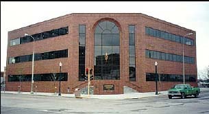

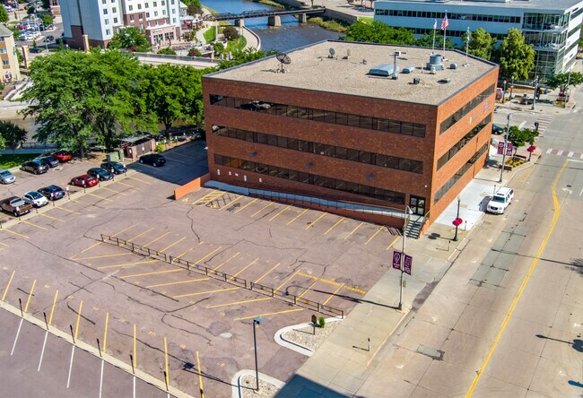

Property Detail
200 N Phillips Ave
59804
LOT 9R BLOCK 1 DOWNTOWN CENTER URBAN RENEWAL SUBD TO CITY OF SIOUX FALLS
Officebuilding
Minnehaha
FP;FP
South Dakota
C and X Area of minimal flood hazard, usually depicted on FIRMs as above the 500-year flood level.
9r
2024
0.85 AC
2024
Downtown Sioux Falls
000701
Other Market Areas
47,448 SF
Sioux Falls, SD-MN
NEARBY LISTINGS FOR SALE OR LEASE
DEMOGRAPHICS near 200 N Phillips Ave
1 mile
3 mile
5 mile
2025 Total Population
17,291
79,512
176,849
2030 Population
18,214
83,176
187,778
Pop Growth 2025-2030
+ 5.34%
+ 4.61%
+ 6.18%
Average Age
39
38
39
2025 Total Households
8,258
33,416
73,788
HH Growth 2025-2030
+ 5.95%
+ 5.11%
+ 6.66%
Median Household Inc
$54,731
$61,251
$69,134
Avg Household Size
1.90
2.20
2.30
2025 Avg HH Vehicles
2.00
2.00
2.00
Median Home Value
$179,708
$239,100
$293,463
Median Year Built
1960
1969
1992
Nearby Places
Map Layers
Map Styles
 Street
 Aerial
Transit
 Traffic
 Biking
Places
Listings with unknown addresses are not visible on the map
- Restaurants
- Banks
- Shops
- Fitness
- Groceries
PUBLIC TRANSPORTATION
AIRPORT
Joe Foss Field
Drive
Walk
Distance
Joe Foss Field
20 min
4.3 mi
SALE & LEASE HISTORY
LISTING DATE
SALE/LEASE

Sep 25, 2016
For Lease
Apr 05, 2022
For Lease
Nearby Properties
Address
Land Use
TOTAL SIZE
Lot Size
Zoning
Address
Land Use
TOTAL SIZE
Lot Size
Zoning
80,415 SF
13.13 AC
Address
Land Use
TOTAL SIZE
Lot Size
Zoning
8.90 AC
C1;NEIGHBO
Address
Land Use
TOTAL SIZE
Lot Size
Zoning
Address
Land Use
TOTAL SIZE
Lot Size
Zoning
Address
Land Use
TOTAL SIZE
Lot Size
Zoning
184,821 SF
1.83 AC
NO;SPECIAL
Address
Land Use
TOTAL SIZE
Lot Size
Zoning
7,252 SF
12.07 AC
Address
Land Use
TOTAL SIZE
Lot Size
Zoning
9.41 AC
Address
Land Use
TOTAL SIZE
Lot Size
Zoning
14,820 SF
80.57 AC
FP;FP
Address
Land Use
TOTAL SIZE
Lot Size
Zoning
360,262 SF
26 AC
Address
Land Use
TOTAL SIZE
Lot Size
Zoning
15,704 SF
5.13 AC
Address
Land Use
TOTAL SIZE
Lot Size
Zoning
3.07 AC
FP;FP
Address
Land Use
TOTAL SIZE
Lot Size
Zoning
1.32 AC
FP;FP
Address
Land Use
TOTAL SIZE
Lot Size
Zoning
1.57 AC
C2;GENERAL
Address
Land Use
TOTAL SIZE
Lot Size
Zoning
51,004 SF
3.99 AC
Address
Land Use
TOTAL SIZE
Lot Size
Zoning
72,553 SF
0.97 AC
Address
Land Use
TOTAL SIZE
Lot Size
Zoning
1.20 AC
FP;FP
Address
Land Use
TOTAL SIZE
Lot Size
Zoning
3,254 SF
2.13 AC
Address
Land Use
TOTAL SIZE
Lot Size
Zoning
99,834 SF
6.58 AC
Address
Land Use
TOTAL SIZE
Lot Size
Zoning
149,520 SF
22.50 AC
Address
Land Use
TOTAL SIZE
Lot Size
Zoning
86,019 SF
3.60 AC
NO;SPECIAL
Address
Land Use
TOTAL SIZE
Lot Size
Zoning
106,064 SF
35.38 AC
Address
Land Use
TOTAL SIZE
Lot Size
Zoning
173,235 SF
10 AC
Address
Land Use
TOTAL SIZE
Lot Size
Zoning
146,718 SF
1.65 AC
Address
Land Use
TOTAL SIZE
Lot Size
Zoning
2.26 AC
FP;FP
Address
Land Use
TOTAL SIZE
Lot Size
Zoning
89,935 SF
4.81 AC
Address
Land Use
TOTAL SIZE
Lot Size
Zoning
18.37 AC
Address
Land Use
TOTAL SIZE
Lot Size
Zoning
62,856 SF
11.26 AC
Address
Land Use
TOTAL SIZE
Lot Size
Zoning
168,359 SF
9.65 AC
NO;SPECIAL
Address
Land Use
TOTAL SIZE
Lot Size
Zoning
0.94 AC
FP;FP
Address
Land Use
TOTAL SIZE
Lot Size
Zoning
92,461 SF
1.28 AC
The World's #1 Commercial Real Estate Marketplace
Connect with us
© 2026 CoStar Group
The information above has been obtained from sources believed reliable. While we do not doubt its accuracy we have not verified it and make no guarantee, warranty or representation about it. It is your responsibility to independently confirm its accuracy and completeness. Any projections, opinions, assumptions, or estimates used are for example only and do not represent the current or future performance of the property. The value of this transaction to you depends on tax and other factors which should be evaluated by your tax, financial, and legal advisors. You and your advisors should conduct a careful, independent investigation of the property to determine to your satisfaction the suitability of the property for your needs.