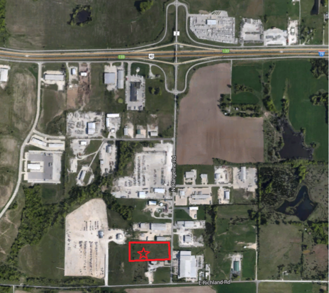
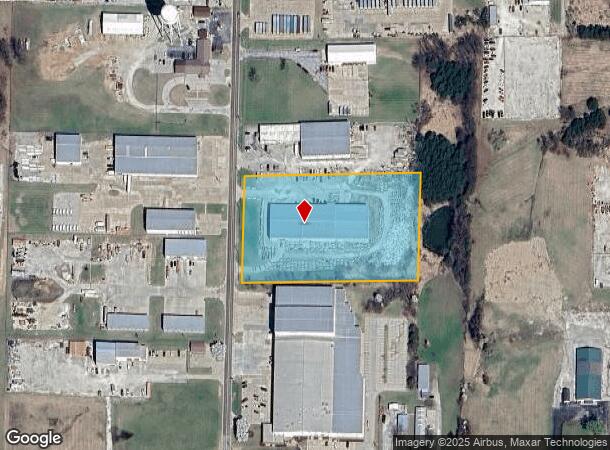
Property Record
200 N Rangeline Rd, Columbia, MO 65201
NEARBY LISTINGS FOR SALE OR LEASE
Property Detail
200 N Rangeline Rd
18-103-07-00-013-00-01
Survey
Industrialgeneral
PT E 1/2 SW SUR 620-605
X
Boone
29019C0305E
Missouri
2025
4.12 AC
2025
Columbia/Jefferson City
001602
Other Market Areas
30,336 SF
Columbia, MO
DEMOGRAPHICS near 200 N Rangeline Rd
1 Mile
3 Mile
5 Mile
2024 Total Population
646
8,746
26,820
2029 Population
673
9,298
28,594
Pop Growth 2024-2029
+ 4.18%
+ 6.31%
+ 6.61%
Average Age
40
39
38
2024 Total Households
286
3,649
11,386
HH Growth 2024-2029
+ 4.55%
+ 6.47%
+ 6.71%
Median Household Inc
$80,482
$81,621
$65,613
Avg Household Size
2.30
2.40
2.30
2024 Avg HH Vehicles
2.00
2.00
2.00
Median Home Value
$178,278
$247,030
$192,233
Median Year Built
1978
1996
1993
Nearby Places
Map Layers
Map Styles
 Street
 Aerial
- Restaurants
- Banks
- Shops
- Fitness
- Groceries
PUBLIC TRANSPORTATION
AIRPORT
Columbia Regional
DRIVE
WALK
Distance
Columbia Regional
22 min
17.7 mi
Freight Ports
Tulsa Port of Inola
DRIVE
WALK
Distance
Tulsa Port of Inola
383 min
340.4 mi
SALE & LEASE HISTORY
LISTING DATE
SALE/LEASE

Dec 26, 2018
For Sale
Nearby Properties
Address
Land Use
TOTAL SIZE
Lot Size
Zoning
Address
Land Use
TOTAL SIZE
Lot Size
Zoning
634,914 SF
91.28 AC
Address
Land Use
TOTAL SIZE
Lot Size
Zoning
77,253 SF
2.53 AC
C3
Address
Land Use
TOTAL SIZE
Lot Size
Zoning
38,236 SF
4.66 AC
C3CP
Address
Land Use
TOTAL SIZE
Lot Size
Zoning
47,520 SF
5.94 AC
Address
Land Use
TOTAL SIZE
Lot Size
Zoning
37,629 SF
6.46 AC
Address
Land Use
TOTAL SIZE
Lot Size
Zoning
32,300 SF
6 AC
CG
Address
Land Use
TOTAL SIZE
Lot Size
Zoning
34,754 SF
33.96 AC
Address
Land Use
TOTAL SIZE
Lot Size
Zoning
29,430 SF
5.88 AC
Address
Land Use
TOTAL SIZE
Lot Size
Zoning
55,822 SF
6.51 AC
ML
Address
Land Use
TOTAL SIZE
Lot Size
Zoning
48,128 SF
22.38 AC
MLP
Address
Land Use
TOTAL SIZE
Lot Size
Zoning
52,956 SF
3.29 AC
C3CP
Address
Land Use
TOTAL SIZE
Lot Size
Zoning
29,385 SF
3.10 AC
CG
Address
Land Use
TOTAL SIZE
Lot Size
Zoning
24,296 SF
29.67 AC
AR
Address
Land Use
TOTAL SIZE
Lot Size
Zoning
21,592 SF
2.04 AC
CG
Address
Land Use
TOTAL SIZE
Lot Size
Zoning
27,154 SF
14.08 AC
Address
Land Use
TOTAL SIZE
Lot Size
Zoning
32,876 SF
2 AC
CG
Address
Land Use
TOTAL SIZE
Lot Size
Zoning
15,290 SF
9.48 AC
Address
Land Use
TOTAL SIZE
Lot Size
Zoning
24,966 SF
7.37 AC
Address
Land Use
TOTAL SIZE
Lot Size
Zoning
14,883 SF
18.30 AC
Address
Land Use
TOTAL SIZE
Lot Size
Zoning
7,298 SF
4.72 AC
Address
Land Use
TOTAL SIZE
Lot Size
Zoning
14,400 SF
3 AC
ML
Address
Land Use
TOTAL SIZE
Lot Size
Zoning
30,530 SF
19.92 AC
CG
Address
Land Use
TOTAL SIZE
Lot Size
Zoning
1,972 SF
3.93 AC
Address
Land Use
TOTAL SIZE
Lot Size
Zoning
60.90 AC
Address
Land Use
TOTAL SIZE
Lot Size
Zoning
28,600 SF
2.65 AC
CGP
Address
Land Use
TOTAL SIZE
Lot Size
Zoning
39,948 SF
7.53 AC
ML
Address
Land Use
TOTAL SIZE
Lot Size
Zoning
32,400 SF
3.86 AC
CG
Address
Land Use
TOTAL SIZE
Lot Size
Zoning
20,640 SF
12.03 AC
A2
Address
Land Use
TOTAL SIZE
Lot Size
Zoning
29,691 SF
4.20 AC
ML
The World's #1 Commercial Real Estate Marketplace
Connect with us
© 2026 CoStar Group
The information above has been obtained from sources believed reliable. While we do not doubt its accuracy we have not verified it and make no guarantee, warranty or representation about it. It is your responsibility to independently confirm its accuracy and completeness. Any projections, opinions, assumptions, or estimates used are for example only and do not represent the current or future performance of the property. The value of this transaction to you depends on tax and other factors which should be evaluated by your tax, financial, and legal advisors. You and your advisors should conduct a careful, independent investigation of the property to determine to your satisfaction the suitability of the property for your needs.