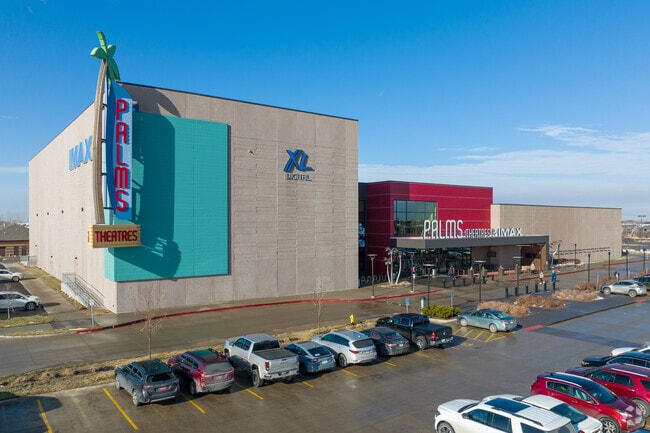
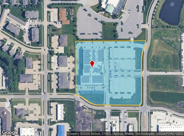
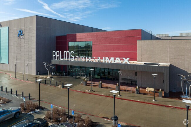
Property Record
200 Ne Westgate Dr, Waukee, IA 50263
NEARBY LISTINGS FOR SALE OR LEASE
Property Detail
200 Ne Westgate Dr
Des Moines-West Des Moines, IA
Fridley Palms Plat 1
12-27-379-002
FRIDLEY PALMS PLAT 1 LOT 1
Theater
Dallas
X
Iowa
19153C0305F
1
2024
8.95 AC
2025
Western Suburbs
050803
Des Moines
66,997 SF
DEMOGRAPHICS near 200 Ne Westgate Dr
1 Mile
3 Mile
5 Mile
2024 Total Population
11,705
55,335
88,952
2029 Population
14,262
66,917
105,925
Pop Growth 2024-2029
+ 21.85%
+ 20.93%
+ 19.08%
Average Age
35
36
37
2024 Total Households
4,503
20,448
34,311
HH Growth 2024-2029
+ 22.67%
+ 21.72%
+ 19.80%
Median Household Inc
$93,340
$108,342
$103,764
Avg Household Size
2.60
2.70
2.60
2024 Avg HH Vehicles
2.00
2.00
2.00
Median Home Value
$283,051
$311,068
$319,990
Median Year Built
2010
2009
2007
Nearby Places
Map Layers
Map Styles
 Street
 Aerial
- Restaurants
- Banks
- Shops
- Fitness
- Groceries
PUBLIC TRANSPORTATION
AIRPORT
Des Moines International
DRIVE
WALK
Distance
Des Moines International
29 min
16.2 mi
Freight Ports
Port Milwaukee
DRIVE
WALK
Distance
Port Milwaukee
430 min
385.2 mi
Nearby Properties
Address
Land Use
TOTAL SIZE
Lot Size
Zoning
Address
Land Use
TOTAL SIZE
Lot Size
Zoning
48,937 SF
76.01 AC
Address
Land Use
TOTAL SIZE
Lot Size
Zoning
72,372 SF
74.45 AC
Address
Land Use
TOTAL SIZE
Lot Size
Zoning
37,325 SF
Address
Land Use
TOTAL SIZE
Lot Size
Zoning
2,864 SF
21.03 AC
Address
Land Use
TOTAL SIZE
Lot Size
Zoning
101,097 SF
30 AC
Address
Land Use
TOTAL SIZE
Lot Size
Zoning
123,722 SF
64.36 AC
Address
Land Use
TOTAL SIZE
Lot Size
Zoning
3,358 SF
21 AC
Address
Land Use
TOTAL SIZE
Lot Size
Zoning
11.91 AC
Address
Land Use
TOTAL SIZE
Lot Size
Zoning
Address
Land Use
TOTAL SIZE
Lot Size
Zoning
24,499 SF
5.75 AC
Address
Land Use
TOTAL SIZE
Lot Size
Zoning
39,505 SF
4.94 AC
Address
Land Use
TOTAL SIZE
Lot Size
Zoning
19.84 AC
Address
Land Use
TOTAL SIZE
Lot Size
Zoning
17.73 AC
Address
Land Use
TOTAL SIZE
Lot Size
Zoning
12.44 AC
Address
Land Use
TOTAL SIZE
Lot Size
Zoning
175,860 SF
40.72 AC
Address
Land Use
TOTAL SIZE
Lot Size
Zoning
17.76 AC
Address
Land Use
TOTAL SIZE
Lot Size
Zoning
87,362 SF
16.87 AC
Address
Land Use
TOTAL SIZE
Lot Size
Zoning
32,439 SF
7.89 AC
Address
Land Use
TOTAL SIZE
Lot Size
Zoning
Address
Land Use
TOTAL SIZE
Lot Size
Zoning
Address
Land Use
TOTAL SIZE
Lot Size
Zoning
121,824 SF
14.72 AC
C-3
Address
Land Use
TOTAL SIZE
Lot Size
Zoning
3,930 SF
8.22 AC
Address
Land Use
TOTAL SIZE
Lot Size
Zoning
66.16 AC
Address
Land Use
TOTAL SIZE
Lot Size
Zoning
88,670 SF
15.44 AC
Address
Land Use
TOTAL SIZE
Lot Size
Zoning
14.16 AC
Address
Land Use
TOTAL SIZE
Lot Size
Zoning
80,271 SF
12.38 AC
Address
Land Use
TOTAL SIZE
Lot Size
Zoning
30,943 SF
2.98 AC
Address
Land Use
TOTAL SIZE
Lot Size
Zoning
5.14 AC
Address
Land Use
TOTAL SIZE
Lot Size
Zoning
71,483 SF
8.26 AC
Address
Land Use
TOTAL SIZE
Lot Size
Zoning
14.31 AC
The World's #1 Commercial Real Estate Marketplace
Connect with us
© 2026 CoStar Group
The information above has been obtained from sources believed reliable. While we do not doubt its accuracy we have not verified it and make no guarantee, warranty or representation about it. It is your responsibility to independently confirm its accuracy and completeness. Any projections, opinions, assumptions, or estimates used are for example only and do not represent the current or future performance of the property. The value of this transaction to you depends on tax and other factors which should be evaluated by your tax, financial, and legal advisors. You and your advisors should conduct a careful, independent investigation of the property to determine to your satisfaction the suitability of the property for your needs.