Property Record
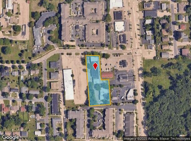
200 Owen Rd, Madison, WI 53716

NEARBY LISTINGS FOR SALE OR LEASE
Property Detail
200 Owen Rd
Madison, WI
LOT 1 CSM 2681 CS10/329&330-12/13/77 DESCR AS SEC 20-7-10 PRT SE1/4NE1/4 (1.67 A CRES) TOG W/ENCROACHMENT AGRMT IN DOC #5168658
0710-201-9910-3
Dane
Commercialnec
Wisconsin
X
1
55025C0437H
1.67 AC
2024
Southeast Madison
2024
Milwaukee/Madison
002900
DEMOGRAPHICS near 200 Owen Rd
1 Mile
3 Mile
5 Mile
2024 Total Population
9,436
50,917
172,878
2029 Population
9,770
52,732
178,439
Pop Growth 2024-2029
+ 3.54%
+ 3.56%
+ 3.22%
Average Age
42
41
36
2024 Total Households
4,447
24,109
76,745
HH Growth 2024-2029
+ 3.67%
+ 3.72%
+ 3.46%
Median Household Inc
$70,334
$75,170
$62,754
Avg Household Size
2.10
2.10
2.00
2024 Avg HH Vehicles
2.00
2.00
1.00
Median Home Value
$296,006
$287,322
$301,718
Median Year Built
1965
1965
1974
Nearby Places
Map Layers
Map Styles
 Street
 Aerial
- Restaurants
- Banks
- Shops
- Fitness
- Groceries
PUBLIC TRANSPORTATION
AIRPORT
Dane County Regional/Truax Field
DRIVE
WALK
Distance
Dane County Regional/Truax Field
16 min
8.4 mi
SALE & LEASE HISTORY
LISTING DATE
SALE/LEASE

Sep 25, 2016
For Lease
Sep 24, 2016
For Sale
Jun 19, 2019
For Lease
Nearby Properties
Address
Land Use
TOTAL SIZE
Lot Size
Zoning
Address
Land Use
TOTAL SIZE
Lot Size
Zoning
280,769 SF
0.80 AC
UMX
Address
Land Use
TOTAL SIZE
Lot Size
Zoning
251,632 SF
3.88 AC
TE
Address
Land Use
TOTAL SIZE
Lot Size
Zoning
296,708 SF
1 AC
TE
Address
Land Use
TOTAL SIZE
Lot Size
Zoning
168,685 SF
14.05 AC
IL
Address
Land Use
TOTAL SIZE
Lot Size
Zoning
13,440 SF
10.98 AC
IL
Address
Land Use
TOTAL SIZE
Lot Size
Zoning
216,017 SF
3.35 AC
TE
Address
Land Use
TOTAL SIZE
Lot Size
Zoning
247,984 SF
1 AC
HIS-L
Address
Land Use
TOTAL SIZE
Lot Size
Zoning
197,046 SF
TE
Address
Land Use
TOTAL SIZE
Lot Size
Zoning
169,491 SF
0.79 AC
HIS-L
Address
Land Use
TOTAL SIZE
Lot Size
Zoning
2.03 AC
Address
Land Use
TOTAL SIZE
Lot Size
Zoning
13.40 AC
Address
Land Use
TOTAL SIZE
Lot Size
Zoning
148,747 SF
0.83 AC
TE
Address
Land Use
TOTAL SIZE
Lot Size
Zoning
115,920 SF
2.38 AC
TE
Address
Land Use
TOTAL SIZE
Lot Size
Zoning
3.59 AC
Address
Land Use
TOTAL SIZE
Lot Size
Zoning
73,125 SF
1.49 AC
HIS-TL
Address
Land Use
TOTAL SIZE
Lot Size
Zoning
192,840 SF
0.37 AC
DC
Address
Land Use
TOTAL SIZE
Lot Size
Zoning
12,450 SF
9.40 AC
SE
Address
Land Use
TOTAL SIZE
Lot Size
Zoning
2.38 AC
Address
Land Use
TOTAL SIZE
Lot Size
Zoning
158,832 SF
0.58 AC
PD
Address
Land Use
TOTAL SIZE
Lot Size
Zoning
4,992 SF
4.09 AC
SE
Address
Land Use
TOTAL SIZE
Lot Size
Zoning
19.81 AC
Address
Land Use
TOTAL SIZE
Lot Size
Zoning
149,897 SF
17.72 AC
IL
Address
Land Use
TOTAL SIZE
Lot Size
Zoning
5.53 AC
Address
Land Use
TOTAL SIZE
Lot Size
Zoning
3.49 AC
Address
Land Use
TOTAL SIZE
Lot Size
Zoning
6,868 SF
18.35 AC
IL
Address
Land Use
TOTAL SIZE
Lot Size
Zoning
202,800 SF
13.05 AC
IL
Address
Land Use
TOTAL SIZE
Lot Size
Zoning
94,290 SF
21.31 AC
SR-V2
Address
Land Use
TOTAL SIZE
Lot Size
Zoning
115,680 SF
56.54 AC
PD
Address
Land Use
TOTAL SIZE
Lot Size
Zoning
101,080 SF
1.02 AC
CC-T
Address
Land Use
TOTAL SIZE
Lot Size
Zoning
13,335 SF
1 AC
TE
The World's #1 Commercial Real Estate Marketplace
Connect with us
© 2026 CoStar Group
The information above has been obtained from sources believed reliable. While we do not doubt its accuracy we have not verified it and make no guarantee, warranty or representation about it. It is your responsibility to independently confirm its accuracy and completeness. Any projections, opinions, assumptions, or estimates used are for example only and do not represent the current or future performance of the property. The value of this transaction to you depends on tax and other factors which should be evaluated by your tax, financial, and legal advisors. You and your advisors should conduct a careful, independent investigation of the property to determine to your satisfaction the suitability of the property for your needs.